TNTmips
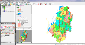
 Line editing with Tntmips Pro 2013 on Windows 7 | |
| Developer(s) | MicroImages, Inc. |
|---|---|
| Initial release | March 3, 1986 |
| Stable release | 2021
/ January 5, 2021 |
Mac OS X Microsoft Windows | |
| Type | Geographic information system |
| License | Proprietary commercial software |
| Website | www |
TNTmips is a
precision farming
).
History
TNTmips was initially branded MIPS from its creation in 1986 until 2022.[1]
General information
TNTmips is a system for fully integrated GIS, CAD, with integrated geospatial database management.[2]
License levels
- TNTmips Pro (professional license),
- TNTmips Basic (low cost license),
- TNTmips Free (freeware).
Special Academic License (SAL)
The TNT products include: TNTmips, TNTedit, TNTview, TNTatlas and TNTsdk. There is no distinction between TNTmips and TNT products with regards to license levels. All TNT products are available for Windows and Macintosh computers in a growing number of international languages.
References
Footnotes
- ^ Pu 2017, p. 245.
- ^ Choudury, Chackrabati & Choudury 2013, p. 153.
Sources
- Choudury, Sujit; Chackrabati, Depankar; Choudury, Suchandra (30 December 2013). An Introduction to Geographic Information Technology. New Delhi; Bangalore: I.K. International. OCLC 957316061– via Googlebooks.
- Pu, Pulliang (16 August 2017). Weng, Qihao (ed.). Hyperspectral Remote Sensing : Fundamentals and Practices. Taylor & Francis series in Remote Sensing Applications. CRC Press. pp. 245–248, xi. OCLC 979566860– via Googlebooks.
External links
