
Taytay, Palawan
Taytay | ||
|---|---|---|
| Municipality of Taytay | ||
 Panoramic | ||
 Flag  Seal | ||
| Nickname: King of Northern Palawan | ||
| Motto(s): Taytay, Una sa Lahat! | ||
| Anthem: Estrella Del Norte Bayan Kong Taytay | ||
 Map of Palawan with Taytay highlighted | ||
OpenStreetMap  | ||
.svg) Taytay Location within the Philippines | ||
| Coordinates: 10°49′N 119°31′E / 10.82°N 119.52°E | ||
| Country | Philippines | |
| Region | Mimaropa | |
| Province | Palawan | |
| District | 1st district | |
Founded | 1623 | |
| Barangays | 31
(see Vice Mayor Delma P. Edep | |
| • Representative | Edgardo L. Salvame | |
| • Municipal Council | Members | |
| • ZIP code | 5312 | |
| PSGC | ||
| IDD : area code | +63 (0)48 | |
| Native languages | Palawano Central Tagbanwa Tagalog | |
Taytay, officially the Municipality of Taytay (
Since 2002, its
History
In the 1200s, the Chinese recorded that the nation
Pigafetta also noted a curious thing in the Kingdom: the natives were fond of cockfighting, long before this pastime was seen or even heard of in the Western Hemisphere.[citation needed]
During the Spanish colonization of the Philippines, Taytay was formally founded in 1623. Taytay became the capital of the province of Calamianes, the entire territory of Paragua (now Palawan), in 1818; and the province of Castilla, a land area occupying the northern part of Palawan, in 1858.[5]
Archived baptismal records in Cuyo, Palawan show that the last monarch of the Kingdom of Taytay was baptised into Catholic Church with the name Flores de los Santos Cabaylo (“Cabaylo, Flower of the Saints”). No other sovereign royal datu after him ruled the kingdom. King Cabaylo's descendants include the present clans of Cabaylo-Manlavi-Gabinete-Macolor as main genealogical roots. His Royal Highness Datu Dr. Fernando Macolor Cruz, who hailed from the Cabailo-Manlavi-Gabinete-Macolor line of the royal house, is the present and sole pretender to the throne of the Kingdom of Taytay.[citation needed]
During the American era, Taytay ceased being Palawan's capital, and its administrative boundary was reduced by approximately 50,000 hectares upon the creation of the
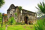
The historic Taytay Fort, the
In 1957, the Island of Debangan was constituted into a barrio.[8]
Geography
Barangays
Taytay is politically subdivided into 31
History of barangays
| Barangay (Barrio) | Creation Date | Mother Territory |
|---|---|---|
| Nasalogan | 1955
|
Sitio of Nasalogan[9] |
| Bambanan | 1956
|
Sitio of Bambanan[10] |
| Sandoval | 1956
|
Sitio of Calatan[11] |
Tumbod. 1972. Liminangcong
Climate
| Climate data for Taytay, Palawan | |||||||||||||
|---|---|---|---|---|---|---|---|---|---|---|---|---|---|
| Month | Jan | Feb | Mar | Apr | May | Jun | Jul | Aug | Sep | Oct | Nov | Dec | Year |
| Mean daily maximum °C (°F) | 29 (84) |
30 (86) |
30 (86) |
31 (88) |
31 (88) |
30 (86) |
29 (84) |
29 (84) |
29 (84) |
29 (84) |
29 (84) |
29 (84) |
30 (85) |
| Mean daily minimum °C (°F) | 23 (73) |
23 (73) |
23 (73) |
24 (75) |
25 (77) |
25 (77) |
24 (75) |
24 (75) |
24 (75) |
24 (75) |
24 (75) |
24 (75) |
24 (75) |
| Average precipitation mm (inches) | 45 (1.8) |
34 (1.3) |
62 (2.4) |
64 (2.5) |
127 (5.0) |
159 (6.3) |
172 (6.8) |
147 (5.8) |
167 (6.6) |
182 (7.2) |
172 (6.8) |
88 (3.5) |
1,419 (56) |
| Average rainy days | 12.1 | 9.4 | 13.0 | 14.3 | 22.7 | 26.9 | 28.0 | 26.4 | 27.0 | 27.0 | 22.7 | 17.8 | 247.3 |
| Source: Meteoblue[12] | |||||||||||||
Demographics
|
| |||||||||||||||||||||||||||||||||||||||||||||||||||
| Source: Philippine Statistics Authority[13][14][15][16] | ||||||||||||||||||||||||||||||||||||||||||||||||||||
In the 2020 census, the population of Taytay, Palawan, was 83,357 people,[3] with a density of 66 inhabitants per square kilometre or 170 inhabitants per square mile.
Economy
Graphs are unavailable due to technical issues. There is more info on Phabricator and on MediaWiki.org. |
Gallery
-
 Taytay Sign
 -
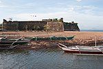 Fort Sta. Isabel
 -
 Chapel inside Fort Sta. Isabel
 -
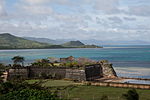 Fortress Sta. Isabel
 -
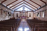
 Inside the church in the fortress of Santa Isabel
 -
 Santa Monica Parish Church
 -
 Night by the sea


References
- (DILG)
- (PDF) from the original on May 25, 2021. Retrieved July 16, 2021.
- ^ a b c Census of Population (2020). "Mimaropa". Total Population by Province, City, Municipality and Barangay. Philippine Statistics Authority. Retrieved July 8, 2021.
- ^ "PSA Releases the 2018 Municipal and City Level Poverty Estimates". Philippine Statistics Authority. December 15, 2021. Retrieved January 22, 2022.
- ^ Palawan Tourism Council: History of Palawan. Accessed August 27, 2008.
- ^ El Nido Tourism Office. Accessed August 28, 2008.
- ^ Official Website of the Province of Palawan Archived August 27, 2008, at the Wayback Machine. Accessed August 28, 2008.
- ^ "Republic Act No.1748, June 21, 1957". Supreme Court E-Library. Retrieved April 2, 2016.
- ^ "Republic Act No.1238, June 07, 1955". Supreme Court E-Library. Retrieved April 2, 2016.
- ^ "Republic Act No. 1525, June 16, 1956". Supreme Court E-Library. Retrieved April 2, 2016.
- ^ "Republic Act No. 1526, June 16, 1956". Supreme Court E-Library. Retrieved April 2, 2016.
- ^ "Taytay: Average Temperatures and Rainfall". Meteoblue. Retrieved November 17, 2019.
- ^ Census of Population (2015). "Region IV-B (Mimaropa)". Total Population by Province, City, Municipality and Barangay. Philippine Statistics Authority. Retrieved June 20, 2016.
- ^ Census of Population and Housing (2010). "Region IV-B (Mimaropa)" (PDF). Total Population by Province, City, Municipality and Barangay. National Statistics Office. Retrieved June 29, 2016.
- ^ Censuses of Population (1903–2007). "Region IV-B (Mimaropa)". Table 1. Population Enumerated in Various Censuses by Province/Highly Urbanized City: 1903 to 2007. National Statistics Office.
{{cite encyclopedia}}: CS1 maint: numeric names: authors list (link) - ^
"Province of Palawan". Municipality Population Data. Local Water Utilities AdministrationResearch Division. Retrieved December 17, 2016.
- ^ "Poverty incidence (PI):". Philippine Statistics Authority. Retrieved December 28, 2020.
- ^ "Estimation of Local Poverty in the Philippines" (PDF). Philippine Statistics Authority. November 29, 2005.
- ^ "2003 City and Municipal Level Poverty Estimates" (PDF). Philippine Statistics Authority. March 23, 2009.
- ^ "City and Municipal Level Poverty Estimates; 2006 and 2009" (PDF). Philippine Statistics Authority. August 3, 2012.
- ^ "2012 Municipal and City Level Poverty Estimates" (PDF). Philippine Statistics Authority. May 31, 2016.
- ^ "Municipal and City Level Small Area Poverty Estimates; 2009, 2012 and 2015". Philippine Statistics Authority. July 10, 2019.
- ^ "PSA Releases the 2018 Municipal and City Level Poverty Estimates". Philippine Statistics Authority. December 15, 2021. Retrieved January 22, 2022.
External links
- Taytay Profile at PhilAtlas.com
- Philippine Standard Geographic Code
- Philippine Census Information
- Local Governance Performance Management System
Places adjacent to Taytay, Palawan | ||||||||||||||||
|---|---|---|---|---|---|---|---|---|---|---|---|---|---|---|---|---|
| ||||||||||||||||
Puerto Princesa (capital and largest city) | |
| Municipalities | |
| Highly urbanized city |
|
| Cultural |
| |
|---|---|---|
| Natural | ||