
Tegher, Armenia
Tegher
Տեղեր | |
|---|---|
UTC+5 |
Tegher (
.The town contains the Monastery of Tegher built in 1213. The ruins of the 9th century village of Tegher (Old Tegher) sit a short distance walk from the monastery. Numerous foundations may be seen, along with the remains of a Tukh Manuk funerary chapel of the 5th century. Nearby is also a medieval to 19th century cemetery with some mausoleums and khachkars.
Nearby is also a large radio telescope as well as an unfinished solar power plant, both from the Soviet era.
Gallery
-
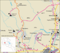 Road map of Tegher and the surrounding region.
 -
 Tegher Monastery
 -
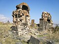 5th century Tukh Manuk Chapel ruins near the monastic complex.
 -
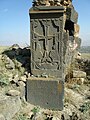 Khachkar at the chapel.


Demographics
| Year | 1831 | 1873 | 1897 | 1922 | 1926 | 1931 | 1939 | 1959 | 2001 | 2004 |
|---|---|---|---|---|---|---|---|---|---|---|
| Population | 35 | 364 | 459 | 506 | 408 | 367 | 655 | 554 | 90 | 261 |
References
External links
Capital: Ashtarak | ||
| Urban settlements | ||
Aparan Municipality | ||
Aragatsavan Municipality | ||
Arevut Municipality | ||
Ashtarak Municipality | ||
Metsadzor Municipality | ||
Shamiram Municipality | ||
Talin Municipality | ||
Tsaghkahovit Municipality | ||