
Tekantó Municipality
Tekantó | |
|---|---|
 Municipal Building of Tekantó | |
|
Central Daylight Time ) | |
| Postal Codes | Tekanto 97520,
Tixkochoh 97522 |
| Area code | 991 |
| Population History | by Year |
MMMD | |
| Municipalities of Yucatán | |
Tekantó Municipality (In the

History
- Before the Spanish conquest of Yucatán the region of Tekantó was part of the chieftainship of Ah Kin Chel (1441–1543).
- 1546: The Spanish conquest of Yucatán that started in 1526 is considered complete.
- 1567: Franciscan Mission founded in Tekantó.[2]
- 1581: Cristobal Sanchez inherits both Tekantó and Tepakan under the encomienda system from his father, the famous conquistador Don Diego Sanchez.[3]
- 1688: Construction of the convent and mission of San Augustin Tekantó is completed.[2]
- 1700: Antonia Pacheco and Juan N. Calderón are responsible for Tekantó under the encomienda system.[4]
- 1720: The legality of the Hacienda system in which laborers were directly employed by the hacienda owners (Sanlatah is a Hacienda in Tekantó municipality).[5]
- 1821: Yucatán declares itself independent of Spain.[6]
- 1825: During this time Tekantó was in the partido of La Costa, which had
- 1848: On May 28 during the Caste War of Yucatán after a 6-day siege Colonel Bello led his force of 1,000 men out of Izamal taking a back trail to Tekantó. From Tekantó he watched Izamal burn.[8]
- 1900: Tekantó Municipality is created and Tekantó becomes its own municipality seat.[1]
Shield
In 1990 the Mexican federal government asked all the municipalities to have their own shield or coat of arms. The City council then presided over by C. Manuel González Towers, decided to hold a contest to produce the shield's design. The design was adapted from submissions by several people. Some notable features of the shield are as follows. A sun with 13 rays that indicate the Mayan supraworld. An illustration of the Mayan chief Ah Kin Chel on a green background. Gold background with
Population
The population of Tekantó is approximately 4,000.
Communities
The municipality is made up from four principle communities, the municipal seat Tekantó along with its neighboring communities Tixkochoh 21°00′50″N 89°04′50″W / 21.0138°N 89.0806°W, San Francisco Dzon 20°59′01″N 89°08′36″W / 20.9835°N 89.1433°W and Sanlatah 21°02′33″N 89°08′48″W / 21.0426°N 89.1466°W). Their populations are as follows: Tekantó 3224, Tixkochoh 455, San Francisco Dzon 127, Sanlatah 83; the census also included 53 people living outside of these communities,[1] either in isolated rural homes or small communities like the hamlet of San Diego Rodriguez 20°59′32″N 89°06′51″W / 20.9923°N 89.1143°W. In 2005 there were 942 houses in the municipality.[11]
Geography

Borders
The municipalities that surround Tekantó Municipality are to the north: Suma and Teya, to the south: Izamal, to the east: Tepakán and to the west: Bokobá.
Nearby cities
The distances from the municipal seat to nearby cities are as follows:
- Yucatán· 13 kilometres (8.1 mi) southeast · 14,954 people.
- Motul, Yucatán · 21 kilometres (13 mi) west-northwest · 21,109 people.
- Merida, Yucatán · 54 kilometres (34 mi) west · 717,175 people.
Tekantó's rail station is on the (now disused) rail line that runs between Mérida and Valladolid via Izamal.
Climate
Warm, with rains during the early summer followed by droughts during the late summer. The annual average temperature is of 26.5 °C and the annual average rainfall is 50 millimeters. The winds are predominantly from the northeast. Relative humidity Annual Average, March 66% - December 89%. The Rainy Season is May through July.[1]
Flora and fauna
Small portions of non-evergreen low forest with secondary vegetation in the ends northeast and the northwest. Including: poppy, bojom, ceiba, chehem, chichibé, pochote and flamboyán. The common animal species that are found in the area include: rabbit, raccoon, deer, armadillo, various snakes, iguanas and turtles; birds: dove, tzutzuy, quail and tórtola.[1]
Places of interest and tourism
Architectural
San Augustin Tekantó is an impressive building and one of the largest churches in the Yucatán outside of


The original mission dates from 1567. According to an inscription on the facade, the church was completed in 1688, over a hundred years after the mission's founding.[2] Near to Tekantó are the hamlets of the ex-properties: Sanlatah and San Francisco Dzon.
Popular celebrations
From 26 to 28 August an annual fiesta is held in honor of the patron saint of Tekantó, San Augustin.
Between 15 and 26 November, an annual fair is held to celebrate Santo Christo de Citilcún. On November 15 each year a procession brings Santo Christo de Citilcún to Tekantó, after the procession there are firework displays and food for sale in the town square. Towards the end of the month there are various festivities including folk dancing, hosted at the town hall; an impromptu bullfighting ring is set up to host bull fights and other events.
Surrounding area
The ruins of Ake are 20 km to the south west of the locality of Tekanto, and Izamal with its world-famous monastery, Victorian era carriages, and mesoamerican pyramids is only 13 km to the south east.
Economy


Tekantó is a municipality that is located in the North central zone of Yucatán that is part of the denominated
With the decline of the
Education
Number of schools by educative level, to the year 2000, according to the Statistical Yearbook of the State of Yucatán, published by the

| Name of School | Locality | Level | Student population |
|---|---|---|---|
| FRANCISCO I. MADERO | Tekantó | Pre-school | 89 |
| PREESCOLAR COMUNITARIO | San Francisco Dzon | Pre-school | 6 |
| SAYABI HA | Tixkochoh | Pre-school | 21 |
| ANDRES QUINTANA ROO | Tekantó | Primary | 164 |
| GUILLERMO PRIETO | Tekantó | Primary | 247 |
| PRIMARIA COMUNITARIA | San Francisco Dzon | Primary | 27 |
| PIPILA | Tixkochoh | Primary | 47 |
| GUILLERMO PRIETO | Tekantó | Secondary | 223 |
Notable people
Notable locals include Marrufo Cetina, Carlos Anastasio. Mandolinista and musical composer (1875–1932).[1]
Gallery
-
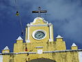 The clock over San Augustin Tekantó.
 -
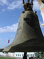 San Augustin Tekantó's Franciscan Bell.
 -
 San Augustin Tekantó's American Bell.
 -
 Local people in traditional dress.
 -
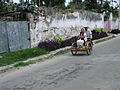
 Downtown Tekantó.
 -
 A nicer home in Tekantó.
 -
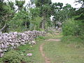 A typical rural street.
 -
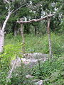 A Well at the edge of town.
 -
 A traditional Cottage.
 -
 The Zócalo (Main Plaza).


See also
Notes
Spelling of Mayan Names:
The spelling of Mayan names (family names, place names and others) will often vary from document to document,
San Francisco Dzon is also known as San Francisco Tzon (
Sanlatah is also known as Sanlatá (
References
- ^ a b c d e f g h i j k l m n "Nuestros municipios - Tekantó". Archived from the original on 2009-09-16. Retrieved 2009-10-21.
- ^ ISBN 0-9620811-9-1
- ^ Loveland Roys, Ralph The political geography of the Yucatan Maya Page 86. Carnegie Institution of Washington (1957). ASIN B0012KNZKY
- ^ Los Municipios de Yucatán p.396. Secretaría de Gobernación, 1988 (in Spanish)
- ^ Alfred J. Andrea, James H. Overfield. The Human Record: Since 1500 p.75. Houghton Mifflin, 1998
- ^ John Macgregor Commercial statistics: A digest of the productive resources, commercial p.1217. Whittaker and co., 1850
- ISBN 0-939238-97-7
- ISBN 0-8047-0164-4
- ^ "Galería de Escudos Mesoamericanos". Archived from the original on 2011-07-22. Retrieved 2009-10-22.
- ^ "De acuerdo al XII Censo General de Población y Vivienda 2000 efectuado por el INEGI". Retrieved 2009-10-22.
- ^ "Enciclopedia de Municipios de México". Archived from the original on 2006-12-05. Retrieved 2009-10-22.
- ISBN 0-939238-97-7
- ^ a b "SCT Map of Yucatan" (PDF). Archived from the original (pdf) on 2009-01-26. Retrieved 2009-10-23.
Mérida (capital) | |||||||||||||||
| Topics |  | ||||||||||||||
| Metros | |||||||||||||||
| Larger cities | |||||||||||||||
| Smaller cities |
| ||||||||||||||
| Municipalities |
| ||||||||||||||