
Horvat Maon (Hebron Hills)
Horvat Ma'on
خربة معين UTC+3 (IDT ) |
|---|
Horvat Maon/Horvat Ma'on,[1][2] Arabic: Khirbet Ma'in[3][4] or Tell Máîn (SWP map No. 25), is an archaeological site in the Hebron Hills, West Bank, rising 863 metres (2,831 ft) above sea level, where the remains of the ancient town of Ma'on (Hebrew: מעון) have been excavated. The town, now a ruin, is mentioned in the Book of Joshua (Joshua 15:55) and the Books of Samuel (1 Samuel 25:2). It still had a Jewish population during the Roman and Byzantine periods, and a synagogue was discovered there. The site is located about 6 kilometres (3.7 mi) southeast of Yatta.
Etymology
The Hebrew name is variously spelled as Horvat Ma'on,[2] Horvat Maon,[1] or Hurbat Ma'on. Tel Ma'on is sometimes also used.[5]
The Hebrew word ma'on means 'dwelling', 'habitation'.[6]
Horvat, horbat, hurbat, hurvat are transliteration variants of the Hebrew word for 'ruins' and direct equivalents of the Arabic
In ancient sources
Hebrew Bible
The site is first mentioned as one of the cities of
Late Roman (?) and Early Byzantine period
After the destruction of the Second Temple, there is again a reference to the site, when Rabban Yohanan ben Zakkai is said to have gone up to Maon of Judah.[7][10]
In the early 4th century CE, Maon was mentioned in Eusebius' Onomasticon as being "in the tribe of Judah; in the east of Daroma."[11] During the Late Roman-Early Byzantine period, Darom or Daroma (Hebrew and Aramaic for "South") became a term used for the southern Hebron Hills in rabbinic literature and in Eusebius' Onomasticon.[12][11] At the time, the Hebron Hills were demographically separated into two distinct districts, with only the southern one retaining a Jewish population along with a newer, Christian one.[13]
Archaeology
Occupation periods
Archaeologists have discovered at the site potsherds dating back to the
Byzantine-period synagogue
A synagogue dating back to the Byzantine/Talmudic period was discovered at Hurvat (Horbat) Ma'on.[15] Two occupation phases were discerned, covering the 4th/5th through the 7th century.[14]
19th-century observations
Tell Maʻîn –– A mound some 100 feet high. On the west are foundations, caves, and cisterns, and foundations of a tower about 20 feet square. The masonry in this tower is large, with a broad irregular draft and a rustic boss. One stone was 3 feet 8 inches long, 2 feet 9 inches high, the draft about 3 inches wide. There is also a round well-mouth, 5 feet diameter, cut out of a single stone.[17]
Modern era
Horbat Maon is situated SE of the Arab town of Yatta, on the north side of regional highway 317. Today,[when?] on the northern slope of the tell are settled several families[who?] who have recently moved there from Yatta.[citation needed]
See also
- Ma'on, Mount Hebron, Israeli settlement, c. 3 km east of the ancient site
Further reading
- ISSN 0334-4479.
- OCLC 26159213.
- Amit, David (2003). Synagogues at Tell Maon and at Tell 'Anim, and the Jewish settlement in the south of Mount Hebron (בתי הכנסת בחורבת מעון ובחורבת ענים והיישוב היהודי בדרום הר חברון). Jerusalem: Hebrew University (Doctoral dissertation). OCLC 170885342.
Gallery
-
![The ancient hill of Tel Ma'on,[which?] South Hebron Hills](//upload.wikimedia.org/wikipedia/commons/thumb/7/7f/Tel-Maon-183.jpg/120px-Tel-Maon-183.jpg) The ancient hill of Tel Ma'on,[which?] South Hebron Hills
The ancient hill of Tel Ma'on,[which?] South Hebron Hills -
 Tel/Horvat Ma'on near Hebron
 -
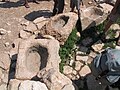 Stone troughs at the well of Ma'on
 -
 Staircase
 -
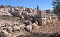
 Ancient remains
 -
 Ancient structures
 -
 Ancient wall
 -
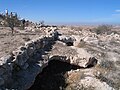
 Remnants of Byzantine fort at Horvat Ma'on
 -
 Detail
 -
 Ancient stones
![The ancient hill of Tel Ma'on,[which?] South Hebron Hills](/File:Tel-Maon-183.jpg)


References
- ^ ISBN 9004112545. Retrieved 8 February 2024.130]
- ^ HA-ESIVolume 122 (2010). Accessed 8 Feb 2024.
- ISBN 965-208-107-8.
- OCLC 6250553. (original Hebrew edition: 'Land of Israel in Biblical Times - Historical Geography', Bialik Institute, Jerusalem (1962))
- ^ David Amit page at IAA website. Accessed 8 Feb 2024.
- ^ "maon or main" (entry 4583). Strong's Concordance, accessed 8 Feb 2024 via Bible Hub.
- ^ a b c d e f Amit (n.d.), pp. 222–223
- ^ Freedman (2000), p. 854
- ^ Guérin (1869), pp. 170–172
- ^ Mekhilta of Rabbi Ishmael on Exodus 19:1
- ^ a b Chapman & Taylor (2003), p. 72.
- OCLC 646899358.
- OCLC 871044531.
- ^ a b c d Magness, Jodi (2003). The Archaeology of the Early Islamic Settlement in Palestine. Eisenbrauns, Vol.1, pp. 96–97. Accessed 8 Feb 2024.
- ^ Amit (1997), p. 155
- Conder (1879), pp. 90–91
- Kitchener (1883), p. 415
Bibliography
- ISBN 1-873938-14-4.
- Amit, David (n.d.). "Hurvat Ma'on". In Ben-Yosef, Sefi (ed.). Israel Guide - Judaea (A useful encyclopedia for the knowledge of the country) (in Hebrew). Vol. 9. Jerusalem: Keter Publishing House, in affiliation with the Israel Ministry of Defence. OCLC 745203905.
- Amit, David (1997), "A marble candelabrum from the synagogue of Maon in Judea", Judea and Samaria Research Studies (מחקרי יהודה ושומרון) (PDF) (in Hebrew), vol. 7, Jerusalem: OCLC 741089250
- Chapman III, Rupert L.; OCLC 937002750.
- OCLC 23589738.
- Conder, C.R.; Kitchener, H.H. (1883). The Survey of Western Palestine: Memoirs of the Topography, Orography, Hydrography, and Archaeology. Vol. 3. London: Committee of the Palestine Exploration Fund.
- ISBN 978-90-5356-503-2.
- Guérin, Victor (1869). Description Géographique Historique et Archéologique de la Palestine (in French). Vol. 1: Judée, pt. 3. Paris: L'Imprimerie impériale.
External links
- Survey of Western Palestine, Map 25: IAA, Wikimedia commons (Tell Máîn shown on upper part of map)