Tessenderlo
Appearance
You can help expand this article with text translated from the corresponding article in Dutch. (September 2022) Click [show] for important translation instructions.
|
Tessenderlo | ||
|---|---|---|
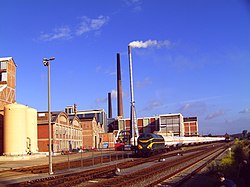
 Chemical plant and rail yard in Tessenderlo | ||
Location in Belgium
Location of Tessenderlo in Limburg Region Flemish Region | | |
| Province | Limburg | |
| Arrondissement | Hasselt | |
| Government | ||
| • Mayor | Karolien Eens (Vooruit-SPiL) | |
| • Governing party/ies | Vooruit-SPiL, CD&V | |
| Area | ||
| • Total | 51.64 km2 (19.94 sq mi) | |
| Population (2018-01-01)[1] | ||
| • Total | 18,514 | |
| • Density | 360/km2 (930/sq mi) | |
| Postal codes | 3980 | |
| NIS code | 71057 | |
| Area codes | 013 | |
| Website | www.tessenderlo.be | |
Tessenderlo (Dutch pronunciation: Taxandrians".
It is along the Albert Canal and the European route E313, the highway between Antwerp and Liège, one of the reasons it was the place for the first Belgian "Industrial Zone of National Importance" in the 1960s.
Tessenderlo was the scene of an infamous industrial disaster during World War II, when a stock of 150 tonnes of ammonium nitrate at the chemical plant of Produits Chimiques de Tessenderloo (now Tessenderlo Group) - located near the centre of town - exploded on April 29, 1942, killing 189 people at the plant and in the town.[2]
Tessenderlo is part of a small western zone of Limburg where the local dialect is not the
Brabantic
.
Notable people
- Kate Ryan, Belgian singer
- Chantal Calin, Belgian singer
- Tia Hellebaut, Olympic Champion 2008 Highjump
- Minus van Looi, writer
References
- ^ "Wettelijke Bevolking per gemeente op 1 januari 2018". Statbel. Retrieved 9 March 2019.
- ^ Goeman, Thierry (2017-04-29). "Vergeten ramp van Tessenderlo kostte 75 jaar geleden aan 190 mensen het leven" [Forgotten Tessenderlo disaster 75 years ago killed 190 people]. Het Nieuwsblad (in Dutch). Mediahuis. Retrieved 2019-02-04.
External links
 Media related to Tessenderlo at Wikimedia Commons
- Official website (in Dutch)


