
The Bugaboos
| The Bugaboos | |
|---|---|
 Snowpatch Spire in the Bugaboos | |
| Highest point | |
| Peak | Howser Spire |
| Elevation | 3,412 m (11,194 ft) |
| Coordinates | 50°44′45″N 116°47′21″W / 50.74583°N 116.78917°W |
| Geography | |
| Country | Canada |
| Province | British Columbia |
| Parent range | Purcell Mountains |
| Geology | |
| Type of rock | Granite batholith |
The Bugaboos are a mountain range in the Purcell Mountains of eastern British Columbia, Canada. The granite spires of the group are a popular mountaineering destination. The Bugaboos are protected within Bugaboo Provincial Park.
Geography
The Bugaboos are located in the northwestern extreme of the Purcells in the Columbia Mountains, in the south-east of the province. The nearest towns are Radium and Golden. They are commonly subdivided into four divisions: the Bugaboo Glacier Peaks, and the Eastern, Central, and Western Spires. The nearby Vowell and Conrad Groups are usually considered separate from the Bugaboos.[1]
Geology
Located in the snow- and rain-heavy "Columbia Wet Belt", this section of the Purcells is subject to heavy erosion and large, active glaciers.
History

Originally named the "Nunataks", the Bugaboo spires were first noted by a surveying expedition in the late 1800s. Mining brought the first Europeans to the region with a small, ill-fated gold rush occurring in 1895 and 1896 near Bugaboo Falls. The area was prospected and staked, but the meager deposits turned out to be mostly pyrite and galena.[4] The name "Bugaboo" originated from this rush; the term was used by prospectors for a "dead-end".[5]
Climbers became interested in the group shortly after. In 1910, an expedition led by
Logging in the area resulted in road construction in the 1950s and 60s. This led to a new influx of climbers.
Climbing and recreation
The Bugaboos have several internationally known rock climbing routes. The Beckey-Chouinard (South Howser Spire), West Ridge (Pigeon Spire), Northeast Ridge (Bugaboo Spire), Snowpatch and Surf's Up (Snowpatch Spire) attract world-class climbers. There are both bolted and free routes throughout the group.[1]
Climbers and hikers often use the 40-person
Spires
- Howser Spire (3412m - North Tower)
- South Howser Tower (3,364m)
- Bugaboo Spire (3204 m)
- Pigeon Spire (3156 m)
- Snowpatch Spire (3084 m)
- Marmolata Mountain (3019m)
- Brenta Spire (2958m)
- Crescent Spire (2842m)
- Crescent Towers (2830m)
- Hound's Tooth (2830m)
- Eastpost Spire (2697m)
- Northpost Spire (2919m)
- Cobalt Lake Spire (2682m)
Gallery
-
 Marmolata Spire and Hound's Tooth
 -
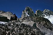
 Pigeon Spire and Howser Spires
 -
 Howser Spires from glacier
 -
 Summit of Pigeon Spire
 -
 Bugaboo Spire at sunrise
 -
 Climbers rope up below Bugaboo Spire
 -
 Climbers rest on Bugaboo Spire
 -
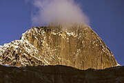
 Snowpatch Spire


References
- ^ ISBN 0-9733035-1-4.
- ^ a b "Bugaboo Provincial Park". British Columbia Ministry of Environment. Retrieved 11 September 2011.
- ^ "082KNE Geological Legend". British Columbia Ministry of Energy and Mines. Retrieved 29 October 2011.
- ISBN 978-1-894765-79-4.
- ^ ISBN 0-89886-795-9.
External links
- Bugaboo Provincial Park
- Climbandmore.com - Climbing destinations
- "The Bugaboos". BC Geographical Names.
| Authority control databases: National |
|---|