
The Ethnographic Open-Air Museum of Latvia
This article needs additional citations for verification. (May 2016) |
Latvijas Etnogrāfiskais brīvdabas muzejs | |
 | |
 | |
| Established | 1924 |
|---|---|
| Location | Berģi, Riga, Latvia |
| Type | Open-air living museum |
| Visitors | 135,000 visitors each year |
| Director | Ilze Millersone |
| Public transit access | City bus No.1 |
| Website | www |

The Ethnographic Open-Air Museum of Latvia (Latvian: Latvijas Etnogrāfiskais brīvdabas muzejs) is an open-air museum located just outside Riga,[1] the capital of Latvia, on the lightly wooded shores of Jugla Lake.
History
In 1924, the Latvian Council of Monuments signed an order to create the open-air museum in Riga. The idea for the new
– to the museum. Each of the buildings would represent the different crafts of each area.The new museum acquired land from a
During
When Latvia regained its independence in 1991, the museum started actively collecting and documenting Latvian heritage from the 1920s and 1930s, a period during which Latvian agrarian reforms reshaped the Latvian countryside. As a result, a new complex of farmers' homesteads from the 1930s was opened in 1997.
Today
Today, the museum organizes many cultural events, such as folk concerts and traditional and craft festivals. The museum promotes traditional
The museum currently occupies 87 hectares and displays 118 buildings, as well as more than 3,000 items. Most of Latvia's historical ethnic groups are represented in the museum. The museum's collection holds approximately 150,000 artifacts.
Gallery
-
 A fisherman's house (Lurķi) from theRucava parish, Courland
 -
 Home of a Russian peasant from Latgale
 -
 Russian Orthodoxchurch from the Rogovka village, Latgale
 -
 Roman Catholicchapel from Latgale
 -
 View of the buildings of Vidzeme homestead
 -
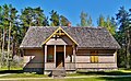 New Farmers dwelling house from the 1930s.Jaungulbene parish, Vidzeme
 -
 Windmill from theRundēni parish, Latgale
 -
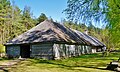 Tavern from theZemgale
 -
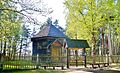
 Gaujiena parish, Vidzeme
 -
![Interior of the Usma Lutheran Church[2]](//upload.wikimedia.org/wikipedia/commons/thumb/d/d1/Latvias_folkemuseum_kirkeinteri%C3%B8r.JPG/120px-Latvias_folkemuseum_kirkeinteri%C3%B8r.JPG) Interior of the Usma Lutheran Church[2]
Interior of the Usma Lutheran Church[2]


.JPG)
![Interior of the Usma Lutheran Church[2]](/File:Latvias_folkemuseum_kirkeinteri%C3%B8r.JPG)
References
- ^ "Latvian Ethnographic Open-Air Museum". Latvia Travel. Retrieved 2016-03-26.
- ^ "KULDĪGAS AKTĪVĀS ATPŪTAS CENTRS – Usma Lutheran Church". Visit.kuldiga.lv. 2015-06-02. Retrieved 2016-03-26.
External links
- Official website (in Latvian and English)
- Mobile App for iPhone
- Mobile App for Android
- Virtual Tour of the Annual Crafts Fair at the Ethnographic Open Air Museum
- Documentary examines the founding of the Latvian Ethnographic Open-Air Museum. January 23, 2021. Public Broadcasting of Latvia. Retrieved: March 19, 2022
56°59′41″N 24°16′12″E / 56.99472°N 24.27000°E
| International | |
|---|---|
| National | |
| People |
|