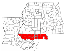
The Floridas
Southern East Florida
is not shown.

The Floridas (
Adams-Onis Treaty
in 1821 the United States combined East Florida and what had been the remaining Spanish-controlled rump of West Florida into the territory that comprised modern-day Florida.
See also
- The Californias
- The Canadas
- The Carolinas
- The Dakotas
- The Virginias
References
- JSTOR 2502623.
- ISBN 978-0-300-05917-5.
Spain never drew a clear line to separate the two Floridas, but West Florida extended easterly to include Apalachee Bay, which Spain shifted from the jurisdiction of St. Augustine to more accessible Pensacola.
- ^ "The Evolution of a State, Map of Florida Counties – 1820". 10th Circuit Court of Florida. Retrieved 2016-01-26.
Under Spanish rule, Florida was divided by the natural separation of the Suwanee River into West Florida and East Florida.
- ^ Klein, Hank. "History Mystery: Was Destin Once in Walton County?". The Destin Log. Retrieved 2016-01-26.
On July 21, 1821 all of what had been West Florida was named Escambia County, after the Escambia River. It stretched from the Perdido River to the Suwanee River with its county seat at Pensacola.
