
Topchanchi
Topchanchi | |
|---|---|
Census Town | |
Tundi | |
| Website | dhanbad |
Topchanchi is a
Geography


5miles
Hill
MC: Municipal Corporation, CT: Census Town, N: Neighbourhood, R: Rural/ Urban centre
Owing to space constraints in the small map, the actual locations in a larger map may vary slightly
Location
Topchanchi is located at 23°54′N 86°12′E / 23.9°N 86.2°E.[1] It has an average elevation of 304 metres (997 feet).
Note: The map alongside presents some of the notable locations in the area. All places marked in the map are linked in the larger full screen map.
Overview
The region shown in the map lies to the north of
Dam and reservoir
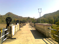
At Topchanchi a stream has been dammed by Jharia water Board at Rajdhato to form a big reservoir from where water is supplied to Dhanbad and its suburbs. This reservoir is famous as Topchanchi lake attracting thousands of tourists around the year.[3] The Topchanchi Water Reservoir spreads over an area of 214 Ac.[4] The Topchanchi Wildlife Sanctuary covers a sprawling plot that measures approximately 8.75 square kilometers. Although the Topchanchi Wildlife Sanctuary is not that spacious yet it manages to preserve the innocuous essence of the wild beasts that reside in it. Grand truck road passes through the middle of topchanchi. You can catch a glimpse of the Parasnath hill from Topchanchi.
Police station
Topchanchi police station serves Topchanchi CD block.[5]
CD block HQ
Headquarters of Topchanchi CD block is at Topchanchi.[6][7]
Demographics
As per the
As of 2001[update] India census,[9] Topchanchi had a population of 5,397. Males constitute 53% of the population and females 47%. Topchanchi has an average literacy rate of 57%, lower than the national average of 59.5%: male literacy is 69%, and female literacy is 43%. In Topchanchi, 15% of the population is under 6 years of age.
Infrastructure
Topchanchi has an area of 3.29 km2. It is 35 km from the district headquarters Dhanbad. The nearest railway station is at Gomoh 12 km away. Buses are available in the town. It has 5 km roads and open drains. The two major sources of protected water supply are hand pumps and tap water from treated source. There are 914 domestic electric connections and 152 road lighting points. Amongst the medical facilities it has 1 hospital with 6 beds. Amongst the educational facilities, it has 2 primary schools, 15 middle schools, 1 secondary school and 1 senior secondary school. The general degree college is available at Gomoh. Amongst the recreational and cultural facilities, the nearest cinema theatre is available at Gomoh There is 1 auditorium/ community hall. It has the branch offices of 6 nationalised banks, 1 cooperative bank and 1 agricultural credit society. [10]
Transport
Topchanchi is on National Highway 19 (old numbering NH 2)/ Grand Trunk Road. A short stretch of local road links it to Gomoh.[11]
Education
St. Thomas High School was established at Topchanchi in 1997. It is a senior secondary school affiliated to the CBSE. It is a residential school. The foremost and the best school in the district of Dhanbad. [12]
Topchanchi picture gallery
-
 Bawan kothi tirpan dham
 -
 Topchanchi Lake
 -
 Topchanchi Park


References
- ^ Falling Rain Genomics, Inc - Topchanchi
- ^ "District Census Handbook Dhanbad" (PDF). Series 21, Part XIIA, pages 4-5, 5-6, 8. Directorate of Census Operations, Jharkhand. Retrieved 4 June 2019.
- ^ "Name and Situatioj" (PDF). Jharkhand Forest Division. Archived from the original (PDF) on 13 July 2011. Retrieved 6 June 2010.
- ^ "Places of tourist interest in Dhanbad district". District Administration. Retrieved 17 April 2010.
- ^ "Dhanbad – Welcome to the Coal Capital of India". Administrative Structure of Dhanbad District – List of Thana and Outpost of Dhanbad. Jharkhand Government. Archived from the original on 24 October 2017. Retrieved 8 October 2017.
- ^ "District Census Handbook 2011 Series 21 Part XIIB" (PDF). Map on Page 3. Directorate of Census Operations, Jharkhand. Retrieved 8 October 2017.
- ^ "CD Block/ Tehsil Map of Dhanbad". Maps of India. Retrieved 8 October 2017.
- ^ "2011 Census C.D. Block Wise Primary Census Abstract Data(PCA)". Jharkhand – District-wise CD Blocks. Registrar General and Census Commissioner, India. Retrieved 11 June 2019.
- ^ "Census of India 2001: Data from the 2001 Census, including cities, villages and towns (Provisional)". Census Commission of India. Archived from the original on 16 June 2004. Retrieved 1 November 2008.
- ^ "District Census Handbook, Dhanbad, 2011, Series 21, Part XII A" (PDF). Pages 639-664 Statements. Directorate of Census Operations, Jharkhand. Retrieved 9 June 2019.
- ^ Google maps
- ^ "St. Thomas High School, Topchanchi". STHS. Retrieved 11 July 2019.
