
Topsail Island
This article's tone or style may not reflect the encyclopedic tone used on Wikipedia. (July 2014) |
 Topsail Island sound side | |
 Topsail Island | |
| Geography | |
|---|---|
| Location | Atlantic Ocean |
| Coordinates | 34°28′11″N 77°28′19″W / 34.46972°N 77.47194°W |
| Length | 26 mi (42 km) |
| Administration | |
US | |
| Additional information | |
 | |
Topsail Island (

It includes the communities of
Name origin
Topsail Island's name[1] is claimed to have derived from its historical use by pirates: according to popular belief,[2] pirates would lie in wait in the channel between the island and the mainland, hoping to capture passing merchant vessels. As word spread about this tactic, mariners supposedly began referring to "Topsail Island" as a pirate vessel's topsail was often the only visible indicator of a planned ambush.
History
Prior to
Immediately after the war, the
Sea turtles
Sea turtle populations are rapidly decreasing due to the increasing populations of humans and rapid degradation of habitats. Recently, efforts have been made to increase these populations by focusing on one main stage of life, the egg site. These sites can be found along the coastlines of beaches up into the sand dunes.[3] There are four main species that can be found on and around the island which are loggerhead, green, leatherback, and Ridley sea turtles.[4] One species specifically that has been the main theme of protection is the Loggerhead Sea Turtle. This turtle has been the basis for the stationing of the Sea Turtle Rescue and Rehabilitation Center in Topsail Island, North Carolina. Their mission is the protection and watching over of the 26 mile stretch of beach that is Topsail Island. They are committed to the overseeing of hatching of the eggs, caring for sick and injured turtles, and protection over the egg site.[5]
Not only do humans disturb the nesting sites of sea turtles, hurricanes play a large role in this as well. Extreme weather will result in the alteration of the nesting site in a negative way by ruining nesting quality through sand erosion. This will cause the turtles to not choose an area that may normally be a safe choice. Also, a hurricane could drown potential eggs reducing the population of the specific turtle that laid the eggs. Occasionally the number of offspring affected will be negligible due to the actual number of eggs being laid at the time of the storm.[6] All five species of sea turtles are listed as endangered under the Endangered Species Act and are under joint jurisdiction under the NOAA Fisheries and the U.S. Fish and Wildlife Service.[7]
Topsail Turtle Project
This project began only due to the turtles nesting on this island. For hundreds of years even before Topsail Island received its name, turtles were laying their eggs on the dunes. The mission began as a few volunteers but has blossomed into quite the operation now. Founded by Karen Beasley, her dream was reached and included tasks provided by volunteers such as walking the beaches at night staking out the nesting sites and overseeing the hatching of the eggs. Only after Karen's death in 1991 did her mother Jean Beasley take over and she still remains at the helm today.[8]
Operation Bumblebee
At the end of World War II the Navy took possession of Topsail Island and began a joint venture with Johns Hopkins University
With the emergence of Operation Bumblebee it brought about the dredging of the waterway, new buildings of roads, and fresh water being piped into the island.[10]
Topsail Island was the third of three widespread test sites established along the Atlantic seaboard in the closing years of World War II, and the first permanent ground for missile testing. The Topsail Island site, placed in operation in March 1947, incorporated rigid structures that were designed and built for specific uses related to the assembly, firing, monitoring, and perfecting of experimental ramjet missiles. The buildings associated with this testing, the Assembly Building, Facility Control Tower, and Observation Tower No. 2 possess exceptional importance because they are the only above ground resources remaining at these three sites where the Nation's burgeoning ramjet missile program grew from experimentation to maturity. The Assembly Building is a one-and-a-half-story masonry building and the Control Tower is a three-story reinforced concrete building. Observation Tower #2 is an unaltered example of the eight instrument towers erected on Topsail Island. Towers #1, #4, #5, and #7 were converted into houses. Tower #3 was also converted into a house, but the addition was destroyed by Hurricane Fran in 1996. Tower #6 was converted into a restaurant and fishing pier, but the pier was also destroyed by Fran, and the addition was demolished later. Tower #8 is the only tower that no longer stands, having been demolished in 1989. The concrete launch pad serves as the patio of the Jolly Roger Motel in Topsail Beach.
Naval and Marine personnel, numbering 500 men, and led by Lieutenant Commander Tad Stanwick, arrived at the site by mid-1946 to begin installation of the facilities needed for the testing. During the next 18 months, an estimated 200 experimental rockets, each measuring six inches in diameter and between three and 13 feet in length, were fabricated at the Assembly Building, dispatched to the launch site, and fired along a northeasterly angular deflection of 15 degrees to the shoreline for a maximum clear distance of 40 miles. Despite the initial success of the US Naval Ordnance Testing facility at Topsail Island over its 18-month span, its location did not fulfill completely the needs of a permanent base because weather conditions and increased sea traffic interfered with testing, and the facility was abandoned and its equipment moved to other sites. [11]
Transportation
Two state highways run along the island and meet in Surf City, which is approximately the geographic center of the island. These are:
- NC 50: From the Surf City Bridge southwards to terminate at the southern tip of the island in Topsail Beach
- NC 210: From the Surf City Bridge northwards to North Topsail Beach, then across the North Topsail Bridge
Gallery
-
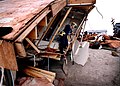 North Topsail Beach, September 6, 1996 — AnUrban Search and Rescue (USAR) Team inspects damaged and destroyed homes for reportedly missing people in the aftermath of Hurricane Fran
 -
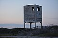 Observation tower on Topsail Island left over from Operation Bumblebee


References
- ^ "Survivor Topsail - Topsail Island History". Archived from the original on 2010-08-24. Retrieved 2010-10-04.
- ^ [1] Archived August 20, 2010, at the Wayback Machine
- ^ Crouse, D. T., Crowder, L.B., Caswell, H. (1987). A Stage-Based Population Model for Loggerhead Sea Turtles and Implications for Conservation. Ecological Society of America, 68. Retrieved from https://www.jstor.org/stable/1939225?seq=2
- .
- ^ Beasley, J. (2012, June). Retrieved from http://www.seaturtlehospital.org/index.htm
- ^ Dewald, J. R., Pike, D. A., & Manne, L. (2014). Geographical variation in hurricane impacts among sea turtle populations" Journal of Biogeography 41(2), 307+. Retrieved from http://go.galegroup.com/ps/i.do?id=GALE%7CA355916666&v=2.1&u=sunycesfsc&it=r&p=AONE&sw=w&asid=65246ac6015e0720beec779b0aebc623
- ^ NOAA Fisheries Office of Protected Resources. (2014). Sea Turtles. Retrieved from http://www.nmfs.noaa.gov/pr/species/turtles/
- ^ Cothran, B. (2006). Topsail Island: Images of America. Arcadian Publishing.
- ^ "Topsail Historical Society - History". Archived from the original on 2008-06-26. Retrieved 2010-10-04.
- ^ Topsail Beach, NC. (2012). History of Topsail Island. Retrieved from http://www.topsailbeach.org/AboutTopsailBeach/HistoryofTopsailBeach/tabid/94/Default.aspx
- ^ "US Naval Ordnance Test Facilities, Topsail". Retrieved 2006-07-02.
External links
- Topsail Beach Home Page
- Sea Turtle Hospital Home Page
- Town of Surf City Home Page
- Town of North Topsail Beach Home Page
- Topsail Advertiser (Weekly Newspaper)
34°28′11″N 77°28′19″W / 34.46972°N 77.47194°W
| International | |
|---|---|
| National | |