
Tromsdalstinden
This article needs additional citations for verification. (May 2023) |
| Tromsdalstinden ( Northern Sami) | |
|---|---|
 Tromsdalstinden as seen from Fløya in August | |
| Highest point | |
| Elevation | 1,238 m (4,062 ft) |
| Prominence | 1,170 m (3,840 ft)[1] |
| Isolation | 9.3 to 9.5 km (5.8 to 5.9 mi) |
| Coordinates | 69°36′26″N 19°08′45″E / 69.6072°N 19.1458°E[2] |
| Geography | |
 Tromsdalstinden Location of the mountain  Tromsdalstinden Tromsdalstinden (Norway) | |
| Location | Troms, Norway |
| Topo map | 1534 III Tromsø |
| Climbing | |
| Easiest route | Hike |
Tromsdalstinden (
Etymology
The Norwegian name Tromsdalstinden means "the peak above Tromsdalen," while the Sami (or Sámi) name comprises Sálaš and Oaivi. The first word signifies a good hunting area; the second translates as "head," but when speaking of landscapes indicates a mountain that is rounded, i.e., does not have any jagged peaks.
Skiing and hiking
Hikers may summit Tromsdalstinden either from the suburb of Tromsdalen or Ramfjorden. The slopes up are relatively straightforward, though fog and rain can complicate the ascent for those unfamiliar with the terrain. When approaching the mountain from the southeast (Ramfjorden), though, hikers and skiers must at one point move over the southwestern or northwestern (city-facing) sides of the mountain as the mountain becomes too steep. The best season for hiking is May through September. Skiers usually take the Fjellheisen aerial tramway to Storsteinen and begin their ascent there. There are two main treks, the Winter and Summer treks.
The Winter trek
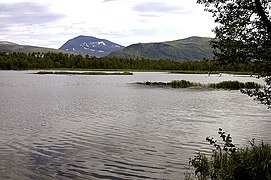
A ski trip that starts on the southwest side of the mountain (on the right in the pictures) is called Salen (the Saddle). When descending, skiers zig-zag down from the top until they reach the little lake Tromsdalsvannet (nor.) or Moskojávri (sám.) in the innermost part of the Tromsdalen valley.
The Summer trek
A hike that starts on the zig-zag trek used to descend when skiing. On the way back, hikers follow the narrow northeastern ridge of the mountain (left on the pictures). The descent route at one point takes you quite close to the steep drop behind the hill which may not be suitable for hikers prone to vertigo. For such hikers, returning the way they came is a better recommendation.
Straight up
Also, ascending from the northwest, i.e., straight up from the valley, is possible. Hikers then start at the Nerloftet (a low plateau above the Tromsdalen valley), proceed to the halfway stop, Loftet (a protruding part of the mountain facing the city), and then go straight up. When the mountain becomes too steep to keep going straight, you go upwards to the right until you're on the 'winter route' (the right slope). The names of these points mean, respectively, the Lower Attic and the Attic. This route is quite steep and thus demanding but safe - although some rocks may be slippery or loose, one should be careful.
Controversy over Sámi cultural significance
This section needs additional citations for verification. (January 2024) |
In 2003 Tromsø applied to host the
The
Professor
Media gallery
-
 Tromsdalstinden is easily visible above Tromsdalen
 -
 The beacon on the summit
 -
 View of the mountain
 -
 View from Prestvannet in the city of Tromsø
 -
 View of the Arctic Cathedral with Tromsdalstinden in the background
 -
 Panoramic view from Tromsdalstinden


References
- ^ "Tromsdalstinden 1238 moh - fakta". Toppomania.
- ^ "Tromsdalstinden, Tromsø (Troms)" (in Norwegian). yr.no. Retrieved 2018-08-12.
- ^ Siv Ellen Kraft: Et hellig fjell blir til - Om samer, OL og arktisk magi. Norwegian only (a holy mountain is created- Samis, olympics and arctic magic) Nytt Norsk Tidsskrift, 2004, Nr 03-04