
Tsovinar, Armenia
Tsovinar
Ծովինար | |
|---|---|
UTC+4 (AMT) | |
| Postal code | 1411 |
| Tsovinar, Armenia at GEOnet Names Server | |
Tsovinar (
.Etymology
The name "Tsovinar" is derived from Tsovinar, the Armenian goddess of water, sea, and rain.
Historical heritage
East of the village is the
Teyseba (Odzaberd) founded by Rusa I around 735-713 BC, with a lengthy but worn cuneiform inscription nearby recounting his conquest of twenty-three nations. It is considered to be the best-preserved Urartian fortification in the Sevan Basin. Below the hill of Teyseba is the point where the Arpa-Sevan Tunnel empties into Lake Sevan. On the hill south of the road that is adjacent to the fortress, are boulders that form walls that are especially visible along the southern boundary.[2]
Just outside the village headed southeast are numerous stones scattered across the side of one of the hills. It is all that remains of an old village destroyed during by war long ago. Some human bones and old coins have been found in this area by villagers from Tsovinar, attesting to the story of what had once taken place there. In close proximity are two small single-nave churches. The church of Topi Galugh sits on a hill southeast between Tsovinar and
Surb Sarkis (1100-1200) sits south of the village of Tsovinar on a promontory overlooking a small gorge. Next to Surb Sarkis is a small cemetery, and just below the church in the gorge is a small spring and cave. Further south are the remains of the ancient village of Karmrashen, which contains the church of Hnevank, the monument of Yot Verk Matur, numerous khachkars
, and some tombs.
Gallery
-
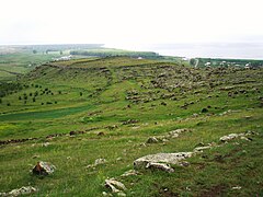 Overlooking Teyseba and Lake Sevan. Tsovinar is located in the distance to the left.
 -
 Cuneiform inscription of Rusa I at the base of the hill of Teyseba, near the road leading towards Artsvanist.
 -
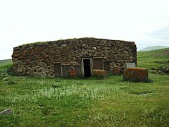
 Ruins of Khrbeh
 -
 Medieval grave outside of St. Sarkis of Tsovinar
 -
 St. Sarkis of Tsovinar
 -
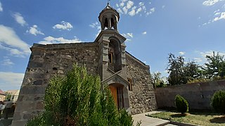 St. Astvatsatsin Church in Tsovinar, from 1900


References
External links
Wikimedia Commons has media related to Tsovinar.
- Report of the results of the 2001 Armenian Census, Statistical Committee of Armenia
- Kiesling, Brady (June 2000). Rediscovering Armenia: An Archaeological/Touristic Gazetteer and Map Set for the Historical Monuments of Armenia (PDF). Archived (PDF) from the original on 6 November 2021.
Capital: Gavar | ||
| Urban settlements | ||
Gavar Municipality | ||
Martuni Municipality | ||
Sevan Municipality | ||
Shoghakat Municipality | ||
Vardenis Municipality |
| |
This article about a location in Gegharkunik Province, Armenia is a stub. You can help Wikipedia by expanding it. |