
Vardenik
Vardenik
Վարդենիկ | |
|---|---|
UTC+4 (AMT) | |
| Postal code | 1418 |
| Vardenik at GEOnet Names Server | |
Vardenik (
Martuni Municipality of the Gegharkunik Province of Armenia, that sits along the Vardenis River. The cyclopean fort ruins of Kaftarli are located 3 km south of the village, with petroglyphs being present downhill along the bank of the river. Some churches and shrines can be found in the vicinity.[2]
The village is the largest rural community in Armenia by population.
Etymology
The village was previously known as Gezeldara, Nerkin Gezaldara, Gyuzeldara and Nizhnyaya Gezaldara.
History
The village was founded in 1828-29 by emigrants from Mush.[2]
Gallery
-
 St. Astvatsatsin Church
 -
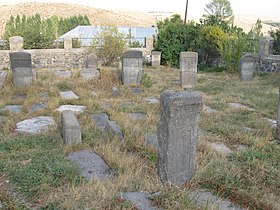 The medieval cemetery of St. Astvatsatsin Church
 -
 Ishkhanavank Church
 -
 Medieval cemetery, Ishkhanavank
 -
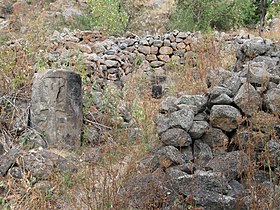 Ruins of the Tsaghkavank Church
 -
 Khachkars
 -
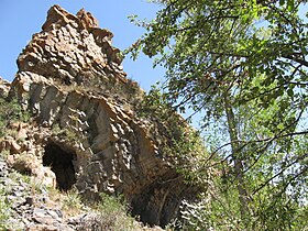 Natural monument "Stone Fortress"


References
External links
Wikimedia Commons has media related to Vardenik (Armenia).
- Report of the results of the 2001 Armenian Census, Statistical Committee of Armenia
- Kiesling, Brady (June 2000). Rediscovering Armenia: An Archaeological/Touristic Gazetteer and Map Set for the Historical Monuments of Armenia (PDF). Archived (PDF) from the original on 6 November 2021.
Capital: Gavar | ||
| Urban settlements | ||
Gavar Municipality | ||
Martuni Municipality | ||
Sevan Municipality | ||
Shoghakat Municipality | ||
Vardenis Municipality |
| |
This article about a location in Gegharkunik Province, Armenia is a stub. You can help Wikipedia by expanding it. |