
Tuizelo
Tuizelo | |
|---|---|
UTC±00:00 (WET) | |
| • Summer (DST) | UTC+01:00 (WEST) |
Tuizelo is a Portuguese freguesia (parish) of the municipality of Vinhais, Bragança district,[2][3] with 34,80 km2 of area and 387 inhabitants (2011); it has a population density of only 11.1 inhabitants per square kilometer.
Located in the north of the municipality, about 12 kilometers from Vinhais, the access is made by EN 316 road. The freguesia houses the villages of Tuizelo, Peleias, Salgueiros, Quadra, Nuzedo de Cima, Cabeça de Igreja, and Revelhe.[4]
History
The area where lies Tuizelo was inhabited before the twelfth century AD, according to the remains of ancient peoples in the region (such as castrejos). Tuizelo derives from the Germanic word "Teodicellus" which is a historical name of a Visigoth king of the Peninsula.[citation needed]
In popular culture
The High Mountains of Portugal, book by Yann Martel is partially set in Tuizelo.
Gallery
-
 Tuizelo, "cimo do povo"
 -
 Casa da Santa, Tuizelo
 -
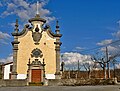 Sanctuary of Nossa Sra. dos Remédios
 -
 Interior of Church of Santo André
 -
 Bicas da Fonte da Senhora
 -
 Fireworks, Tuizelo
 -
 Smokehouse, Tuizelo


References
- ^ "Statistics Portugal – Web Portal". www.ine.pt.
- ^ "Portal Autárquico". www.portalautarquico.dgal.gov.pt. Retrieved 2018-09-26.
- ^ Centrais, Portugal Instituto Nacional de Estatística Serviço (1971). 10o. recenseamento geral da população: no continente e ilhas adjacentes, às 0 horas de 15 de Dezembro de 1960 (in Portuguese).
- ^ Neto, Joaquim Maria (1975). O leste do território bracarense (in Portuguese). [s.n.], 1975 (Torres Vedras.