
Twin Bridges, Montana
Twin Bridges, Montana | ||
|---|---|---|
FIPS code 30-75475 | | |
| GNIS feature ID | 0792499 | |
| Website | twinbridgesmt.com | |
Twin Bridges is a town in
History

Four Indian trails came together at a bend of the Beaverhead River north of the present school building in Twin Bridges. These trails were used by early settlers and freight companies, and helped to establish where the community of Twin Bridges would develop. Judge M.H. Lott came to Montana in 1862, and with his brother John T. Lott, settled in the Ruby Valley in 1864. In 1865 they built a bridge across the Beaverhead River, and later built another bridge across the Beaverhead at the Point of Rocks.[6] The Lott brothers continued development of roads and promoted settlement of the town, which was incorporated in 1902, with M.H. Lott as the first mayor.
Geography
According to the United States Census Bureau, the town has a total area of 0.96 square miles (2.49 km2), all land.[7]
Climate
According to the
| Climate data for Twin Bridges, Montana (1991–2020 normals, extremes 1955–present) | |||||||||||||
|---|---|---|---|---|---|---|---|---|---|---|---|---|---|
| Month | Jan | Feb | Mar | Apr | May | Jun | Jul | Aug | Sep | Oct | Nov | Dec | Year |
| Record high °F (°C) | 62 (17) |
65 (18) |
78 (26) |
86 (30) |
93 (34) |
99 (37) |
101 (38) |
101 (38) |
98 (37) |
87 (31) |
73 (23) |
68 (20) |
101 (38) |
| Mean daily maximum °F (°C) | 35.4 (1.9) |
39.6 (4.2) |
49.2 (9.6) |
57.0 (13.9) |
66.4 (19.1) |
74.7 (23.7) |
84.7 (29.3) |
83.4 (28.6) |
73.5 (23.1) |
59.3 (15.2) |
44.1 (6.7) |
34.5 (1.4) |
58.5 (14.7) |
| Daily mean °F (°C) | 24.2 (−4.3) |
27.3 (−2.6) |
35.5 (1.9) |
42.5 (5.8) |
51.3 (10.7) |
58.7 (14.8) |
65.4 (18.6) |
63.3 (17.4) |
55.1 (12.8) |
43.6 (6.4) |
31.7 (−0.2) |
23.3 (−4.8) |
43.5 (6.4) |
| Mean daily minimum °F (°C) | 13.0 (−10.6) |
15.1 (−9.4) |
21.9 (−5.6) |
28.0 (−2.2) |
36.1 (2.3) |
42.7 (5.9) |
46.1 (7.8) |
43.2 (6.2) |
36.7 (2.6) |
27.9 (−2.3) |
19.3 (−7.1) |
12.0 (−11.1) |
28.5 (−1.9) |
| Record low °F (°C) | −39 (−39) |
−32 (−36) |
−28 (−33) |
2 (−17) |
12 (−11) |
24 (−4) |
28 (−2) |
23 (−5) |
10 (−12) |
−9 (−23) |
−27 (−33) |
−35 (−37) |
−39 (−39) |
| Average precipitation inches (mm) | 0.22 (5.6) |
0.22 (5.6) |
0.37 (9.4) |
0.85 (22) |
1.70 (43) |
2.17 (55) |
0.89 (23) |
0.75 (19) |
0.88 (22) |
0.73 (19) |
0.33 (8.4) |
0.33 (8.4) |
9.44 (240) |
| Average precipitation days (≥ 0.01 in) | 3.4 | 3.9 | 4.8 | 8.4 | 11.0 | 11.7 | 6.4 | 6.6 | 5.5 | 5.9 | 4.8 | 5.1 | 77.5 |
| Source: NOAA[9][10] | |||||||||||||
Demographics
| Census | Pop. | Note | %± |
|---|---|---|---|
| 1910 | 491 | — | |
| 1920 | 755 | 53.8% | |
| 1930 | 671 | −11.1% | |
| 1940 | 534 | −20.4% | |
| 1950 | 497 | −6.9% | |
| 1960 | 509 | 2.4% | |
| 1970 | 613 | 20.4% | |
| 1980 | 437 | −28.7% | |
| 1990 | 374 | −14.4% | |
| 2000 | 400 | 7.0% | |
| 2010 | 375 | −6.2% | |
| 2020 | 330 | −12.0% | |
| U.S. Decennial Census[11][5] | |||
2010 census
As of the
There were 172 households, of which 25.0% had children under the age of 18 living with them, 42.4% were married couples living together, 7.0% had a female householder with no husband present, 5.2% had a male householder with no wife present, and 45.3% were non-families. 37.2% of all households were made up of individuals, and 18% had someone living alone who was 65 years of age or older. The average household size was 2.18 and the average family size was 2.91.[13]
The median age in the town was 44.6 years. 22.7% of residents were under the age of 18; 5.1% were between the ages of 18 and 24; 22.6% were from 25 to 44; 30.7% were from 45 to 64; and 18.9% were 65 years of age or older. The gender makeup of the town was 54.7% male and 45.3% female.
2000 census
As of the
There were 175 households, out of which 25.7% had children under the age of 18 living with them, 50.3% were married couples living together, 6.9% had a female householder with no husband present, and 40.0% were non-families. 34.9% of all households were made up of individuals, and 13.7% had someone living alone who was 65 years of age or older. The average household size was 2.29 and the average family size was 2.95.
In the town, the population was spread out, with 25.3% under the age of 18, 4.3% from 18 to 24, 24.8% from 25 to 44, 28.0% from 45 to 64, and 17.8% who were 65 years of age or older. The median age was 42 years. For every 100 females, there were 92.3 males. For every 100 females age 18 and over, there were 94.2 males.
The median income for a household in the town was $25,833, and the median income for a family was $34,688. Males had a median income of $25,417 versus $16,250 for females. The
Economy
Twin Bridges serves as a tourist destination for both fly fishers and cyclists. The town sits on two long-distance cycling trails - the
Arts and culture
The Twin Bridges Historical Association Museum, located in one of the first commercial buildings in town, displays artifacts relating to the area history.[17] Displays include indigenous culture, pioneers, and mining and agriculture information.
The Twin Bridges Public Library has been serving the community since 1897.[18] It was created by the Temperance Society as an alternative to saloons.
The Doncaster Round Barn is a 3-story round barn that is listed on the National Register of Historic Places.[19] The property was used for horse-breeding and produced Spokane, the winner of the 1889 Kentucky Derby.[19]
Education
Twin Bridges Public Schools educate students from kindergarten through 12th grade.[20] The Twin Bridges Public Library serves the area.[21]
Media
The Madisonian is a newspaper serving the Madison and Ruby Valleys, which includes Twin Bridges.[22] It is printed weekly and offers an e-edition.
Infrastructure
Ruby Valley Field is a public use airport located two miles (4 km) southeast of town.[23]
Notable people
- Angela McLean, lieutenant governor of Montana
- Alonso Pardo Vargas, Prom prince and chemist [24]
- Metropolitan Museumin New York
- Benny Reynolds, rodeo champion
- Donald Rumsfeld, American political figure and businessman[25]
- Spokane, winner of the 1889 Kentucky Derby[26]
- Kenneth Walsh, member of the Montana House of Representatives
See also
- The Round Barn at Twin Bridges, once described as a "swank hotel for horses," is on the National Register of Historic Places.[26]
Gallery
-
 Northern Entrance To Twin Bridges, MT
 -
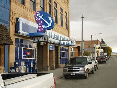 Blue Anchor Cafe, Main Street, Twin Bridges, MT


Notes
- ^ "ArcGIS REST Services Directory". United States Census Bureau. Retrieved September 5, 2022.
- ^ USGS Place names
- ^ 2000 Census from City-Data.com
- ISBN 1-58574-331-3.
- ^ a b "U.S. Census website". United States Census Bureau. Retrieved November 2, 2021.
- ^ "Twin Bridges". Montana Place Names Companion. Montana Historical Society. Retrieved 9 April 2021.
- ^ "US Gazetteer files 2010". United States Census Bureau. Archived from the original on 2012-01-25. Retrieved 2012-12-18.
- ^ Climate Summary for Twin Bridges, Montana
- ^ "NOWData - NOAA Online Weather Data". National Oceanic and Atmospheric Administration. Retrieved December 14, 2023.
- ^ "Summary of Monthly Normals 1991-2020". National Oceanic and Atmospheric Administration. Retrieved December 14, 2023.
- ^ "Census of Population and Housing". Census.gov. Retrieved June 4, 2015.
- ^ "U.S. Census website". United States Census Bureau. Retrieved 2012-12-18.
- ^ Government of Canada, Statistics Canada (2017-12-13). "Appendix G - Estimated number of households and average household size by domain, Canada". www150.statcan.gc.ca. Retrieved 2024-02-23.
- ^ "U.S. Census website". United States Census Bureau. Retrieved 2008-01-31.
- ^ "Twin Bridges: Rural Friendliness Pays Dividends | Adventure Cyclist". Adventure Cycling Association. 2017-04-26. Retrieved 2020-02-17.
- ^ Giddings, Caitlin (2016-02-08). "How Bike Touring Saved This Small Town". Bicycling. Retrieved 2020-02-17.
- ^ "Twin Bridges Historical Association and Museum". Montana Office of Tourism. Retrieved 29 August 2023.
- ^ "History". Twin Bridges Public Library. Retrieved 29 August 2023.
- ^ a b "National Register of Historic Places Registration Form" (PDF). Montana Historical Society. Retrieved 29 August 2023.
- ^ "Twin Bridges Public Schools". Twin Bridges Public Schools. Retrieved 13 April 2021.
- ^ "Twin Bridges Public Library". Montana State Library. Retrieved 13 April 2021.
- ^ "Home page". The Madisonian. Retrieved 27 August 2023.
- ^ "RVF (KRVF)". FAA. Retrieved 27 August 2023.
- ^ "https://orbit.dtu.dk/en/persons/alonso-pardo-vargas"
- ^ O’Brien, Gerard. "Rumsfeld in retirement".
- ^ a b Briggeman, Kim. “1889 Derby Winner Directed National Attention to Iconic Round Barn in Twin Bridges.” Missoulian, May 3, 2015 edition. Accessed May 3, 2015.
External links
Municipalities and communities of Madison County, Montana, United States | ||
|---|---|---|
| Towns |  | |
| CDPs | ||
| Other communities | ||
| Ghost towns | ||
| Footnotes | ‡This populated place also has portions in an adjacent county or counties | |
| ||