
Umfolozi River
| Umfolozi River | |
|---|---|
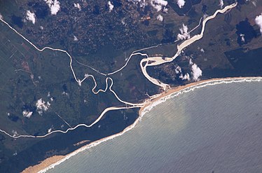
 Satellite image of the Umfolozi and Hluhluwe River rivers converging at the St. Lucia estuary in the iSimangaliso Wetland Park, in northern KwaZulu-Natal | |
 | |
 Location of the Umfolozi River mouth | |
| Native name | imFolozi (Zulu) |
| Location | |
| Country | South Africa |
| Province | KwaZulu-Natal |
| Physical characteristics | |
| Mouth | |
• location | KwaZulu-Natal, South Africa |
• coordinates | 28°23′32″S 32°25′27″E / 28.39222°S 32.42417°E |
The Umfolozi River (also uMfolozi, Imfolozi or Mfolozi) is a river in
The river flows in an easterly direction to the Indian Ocean at Maphelana, a coastal resort just south of the St Lucia River mouth. It originally meandered over the Monzi Flats, where it split into numerous slow-flowing channels before entering the St. Lucia Estuary at Honeymoon Bend. The slow-moving water and reed beds in channels operated as a natural filtering system that removed silt from the Umfolozi floodwaters and created a rich habitat for numerous species.
Ecology
During the 1950s, the Umfolozi Landowners Association contained and artificially channelled the river through the Monzi Flats to develop sugarcane farms. The new Umfolozi canal resulted in the unfiltered water depositing its silt load after entering the slower moving St. Lucia Estuary. This caused the estuary mouth to rapidly silt up. There had only been one record of this occurring until that time, during the sustained drought during the 1930s.
At 28°20′58″S 31°58′46″E / 28.34944°S 31.97944°E the Black Umfolozi River and the White Umfolozi River, join to form the Umfolozi.
Characteristics
It is a meandering river, with a catchment area of 11,068 km3. It is 38 metres wide near its mouth, with a slope gradient of 0.36 m/km. The average diameter of the bed material is 0.35 mm (sand).[2]
Sediment problems
The river transports carries annually 1.4 million tonnes of
Fish
The
Aerial photos
-
 The Mfolozi Rivers are seen converging on the iSimangaliso Wetland Park
 -

See also
- List of rivers of South Africa
- List of estuaries of South Africa
- List of dams in South Africa
- List of drainage basins of South Africa
- Water Management Areas
References
- ISBN 0-624-00273-X.
- ^ S2CID 199099061.
- ^ "Technical Report on the State of Yellowfishes in South Africa 2007" (PDF). Archived from the original (PDF) on 2017-06-29. Retrieved 2012-03-29.