Upper Catesby
| Upper Catesby | |
|---|---|
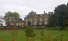
 Catesby House | |
Location within Northamptonshire | |
| OS grid reference | SP526593 |
| Civil parish | |
| Unitary authority | |
| Ceremonial county | |
| Region | |
| Country | England |
| Sovereign state | United Kingdom |
| Post town | Daventry |
| Postcode district | NN11 |
| Dialling code | 01327 |
| Police | Northamptonshire |
| Fire | Northamptonshire |
| Ambulance | East Midlands |
| UK Parliament | |
| Website | Catesby (Parish Meeting) |
Upper Catesby is a
Archaeology
In 1895 during the sinking of a shaft for Catesby Tunnel a Roman cinerary urn was found about 575 yards (526 m) south of Upper Catesby.[1]
Village
The village's name means 'farm/settlement of Katr/Kati'.[2]
In 1389 Upper Catesby was recorded as Overcatsby.
Catesby House
Catesby House is a Jacobethan country house about 400 yards (370 m) west of Upper Catesby. It was built in 1863 and enlarged in 1894.[3][4] It includes 16th-century linenfold panelling said to come from Catesby Priory,[3] and 17th-century panelling,[3] doorcases and a stair with barley-sugar balusters,[3] all from the previous 17th-century Catesby House[4] that was in Lower Catesby.
Catesby Tunnel

Catesby Tunnel is a disused railway tunnel on the route of the former Great Central Main Line. It passes about 250 yards (230 m) west of Upper Catesby and about 100 yards (91 m) east of Catesby House. The tunnel's north portal is about 400 yards (370 m) northwest of the hamlet, and its south portal is about 0.6 miles (1 km) north of Charwelton, just inside the southern boundary of Catesby parish.
References
- ^ a b c d e f RCHME 1981, pp. 37–43
- ^ "Key to English Place-names".
- ^ a b c d Pevsner & Cherry 1973, p. 145.
- ^ a b Historic England (24 February 1987). "Catesby House (1075311)". National Heritage List for England. Retrieved 9 November 2013.
Sources
- Boyd-Hope, Gary; Sargent, Andrew (2007). Railways and Rural Life: S W A Newton and the Great Central Railway. Swindon: ISBN 978-185074-959-2.
- ISBN 0-14-071022-1.
- RCHME, ed. (1981). "Catesby". An Inventory of the Historical Monuments in the County of Northamptonshire. Vol. 3 – Archaeological sites in North-West Northamptonshire. London: Royal Commission on the Historical Monuments of England. pp. 37–43.


