
User:Spitzmauskc/Sandbox/Húnaflói
| Spitzmauskc/Sandbox/Húnaflói | |
|---|---|
 Location of Húnaflói in Iceland | |
| Location | Northwestern Region and Westfjords |
| Coordinates | 65°50′N 20°50′W / 65.833°N 20.833°W |
| Type | Bay |
| Etymology | húnn meaning 'polar bear cub'[1] + flói meaning 'bay'[2] |
| Ocean/sea sources | Iceland Sea |
| Max. length | 100 km (60 mi) |
| Max. width | 50 km (30 mi) |
| Surface area | 188.8 km2 (70 sq mi) |
| Islands | |
| Settlements | |
Húnaflói (Icelandic pronunciation: [ˈhuːnaˌflouːɪ]) is a bay of the Iceland Sea in Northwestern Region and Westfjords, Iceland. It is situated between Strandir of Vestfirðir peninsula on the west and the Skagaströnd of Skagi peninsula on the east. Spanning 188.8 km2 (70 sq mi), it has a maximum width of about 50 km (30 mi) and length of 100 km (60 mi).[3]
Geography

Fjords
The major features of Húnaflói are its seven
In the southwest of Húnaflói is the 36 km (22 mi) long Hrútafjörður, the bay's longest fjord. The southern tip of Hrútafjörður traditionally marked the boundary between the regions of Vestfjörður and Norðurland.
Continuing east is the Vatnsnes peninsula, which forms the western edge of Húnafjörður, the largest fjord of Húnaflói. Skagi peninsula is the eastern extent of Húnafjörður and of the entire Húnaflói. ('Coast of Skagi' or lit. 'Coast of the Peninsula')
geographic features in Húnaflói are first attested: Borðeyri, Grímsey, Hrútafjörður, Húnavatn.
Settlements and other features
Húnaflói and Much of its geography are documented in Landnámabók and several sagas of Icelanders, including Gull-Þóris saga, Gísla saga, Grettis saga, and Vatnsdæla saga, among others. Together the historical record and corroborating archaeological evidence suggest that continuous human presence in Húnaflói started during the settlement of Iceland in the late ninth century.
Today, Húnaflói supports a population in the low thousands and has several localities of more than one hundred inhabitants. The population centers are all situated along fjords, excepting the village of Skagaströnd, which lies directly on the eastern shore of Húnaflói.

Steingrímsfjörður in the Westfjords supports two settlements, Drangsnes and Hólmavík. The largest settlement on Strandir, Hólmavík has 302 residents and forms the municipality of Strandabyggð's urban nucleus. Situated near the mid-point of Steingrímsfjörður's fertile southern shore, it is surrounded by farmland.
Drangsnes sits at the northeastern point of Steingrímsfjörður, where it meets Húnaflói. The hamlet is the largest settlement in Kaldrananeshreppur despite having just 71 inhabitants. Several kilometers west of Drangsnes is Strákatangi, the site of a 17th century Basque whaling station where whales were processed before being shipped.[4]
The 49 ha (120 acres) island Grímsey sits less than 2 km (1.2 mi) off the coast of Drangsnes. According to Landnámabók, the island was named after Grími Ingjaldssyni Hróaldssonar from Haddingjadal, who overwintered on the island and drowned while rowing to the mainland. The island's name is often elaborated as Grímsey á Steingrímsfirði (lit. 'Grímsey on Steingrímsfjörður') to distinguish it from the larger island of the same name in Akureyri municipality.
Historically, the southern point of Hrútafjörður marked the border between the
The small town of
- Blönduós – 845, largest settlement of Húnabyggð (1295)
- Drangsnes – 71, largest settlement of Kaldrananeshreppur (116)
- Hólmavík – 302, largest settlement on Strandir and of Strandabyggð (428)
- Hvammstangi – 625, largest settlement of Húnaþing vestra (1258)
- Skagaströnd – 457, largest settlement of Sveitarfélagið Skagaströnd (484)
Fauna
The bay has been proposed as a protected area for harbor seals.[5] Illugastaðir on the northwestern coast of Vatnsnes
Grímsey á Steingrímsfirði hosts a colony of 25–30 thousand breeding pairs of
-
 Harbor seals in Hindisvík
 -
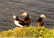 Atlantic puffins on Grímsey á Steingrímsfirði
 -
 An Icelandic horse by the Húnaflói


Image gallery
-
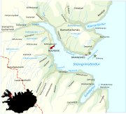 Map detail of Bjarnarfjörður, Steingrímsfjörður, and Kollafjörður with the villages Hólmavík and Drangsnes, and the island Grímsey
 -
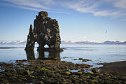 Hvítserkur basalt stack along the eastern shore of the Vatnsnes
 -
 Grímsey á Steingrímsfirði as seen from the coast near Drangsnes
 -
 Blönduóshreppur


.jpg)

References
- ^ Svavar Sigmundsson (7 December 2016). "Hvaðan er forskeytið húna í Húnaflóa komið?". Vísindavefurinn (in Icelandic). Retrieved 5 August 2023.
- ^ Williams, Richard S. (October 1995). "Icelandic-English Glossary of Selected Geoscience Terms (USGS Open-file Report 95-807)". United States Geological Survey. Retrieved 5 August 2023.
{{cite web}}: CS1 maint: url-status (link) - ^ "Náttúruminjaskrá: Húnaflói". Icelandic Institute of Natural History (in Icelandic and English). 3 December 2020. Retrieved 4 August 2023.
- ^ Magnús Rafnsson; Ragnar Edvardsson (February 2009), Foreign Whaling in Iceland – Archaeological Excavations at Strákatangi in Hveravík, Kaldrananeshreppi 2008 (PDF), Náttúrustofa Vestfjarða, retrieved 4 August 2023 – via North Atlantic Biocultural Organization
- ^ "Leggja til að Rjúkandi og Hvalá verði friðuð" (in Icelandic). RÚV. 14 December 2020. Retrieved 5 April 2022.
- ^ "Grímsey á Steingrímsfirði". Icelandic Institute of Natural History (in Icelandic and English). Retrieved 29 July 2023.