
Vers-Pont-du-Gard
Vers-Pont-du-Gard | |
|---|---|
 | |
.svg) Coat of arms | |
Location of Vers-Pont-du-Gard  | |
 Vers-Pont-du-Gard  Vers-Pont-du-Gard | |
| Coordinates: 43°58′10″N 4°31′30″E / 43.9694°N 4.525°E | |
| Country | France |
| Region | Occitania |
| Department | Gard |
| Arrondissement | Nîmes |
| Canton | Redessan |
| Intercommunality | Pont du Gard |
| Government | |
| • Mayor (2020–2026) | Olivier Sauzet[1] |
| Area 1 | 19.14 km2 (7.39 sq mi) |
| Population (2021)[2] | 1,773 |
| • Density | 93/km2 (240/sq mi) |
| Time zone | UTC+01:00 (CET) |
| • Summer (DST) | UTC+02:00 (CEST) |
| INSEE/Postal code | 30346 /30210 |
| Elevation | 15–192 m (49–630 ft) (avg. 52 m or 171 ft) |
| 1 French Land Register data, which excludes lakes, ponds, glaciers > 1 km2 (0.386 sq mi or 247 acres) and river estuaries. | |
Vers-Pont-du-Gard (French pronunciation: [vɛʁs pɔ̃ dy ɡaʁ]; Vèrs in Occitan) is a commune in the Gard department in southern France.
The Pont du Gard is located on the territory of the commune.
Gallery
-
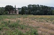 Chapelle Saint-Pierre
 -
 Ancient Roman aqueduct.


Population
| Year | Pop. | ±% |
|---|---|---|
| 1962 | 603 | — |
| 1968 | 644 | +6.8% |
| 1975 | 739 | +14.8% |
| 1982 | 924 | +25.0% |
| 1990 | 1,110 | +20.1% |
| 1999 | 1,322 | +19.1% |
| 2008 | 1,653 | +25.0% |
International relations
Vers-Pont-du-Gard is twinned with:
See also
References
- ^ "Répertoire national des élus: les maires" (in French). data.gouv.fr, Plateforme ouverte des données publiques françaises. 13 September 2022.
- ^ "Populations légales 2021". The National Institute of Statistics and Economic Studies. 28 December 2023.
External links
Wikimedia Commons has media related to Vers-Pont-du-Gard.
| International | |
|---|---|
| National | |
This Gard geographical article is a stub. You can help Wikipedia by expanding it. |