
Vilapakkam
Vilapakkam
kapithapuram in Sanskrit | |
|---|---|
town | |
| Nickname: VPK | |
| Country | UTC+5:30 (IST ) |
Vilapakkam is a
Demographics
As of 2001[update] India census,[1] Vilapakkam had a population of 8053. Males constitute 50% of the population and females 50%. Vilapakkam has an average literacy rate of 68%, higher than the national average of 59.5%: male literacy is 77%, and female literacy is 58%. In Vilapakkam, 11% of the population is under 6 years of age. Vilapakkam is situated to the south of Arcot in Ranipet District. This town is around 25 km south-east of Vellore. Kavanur is in the west and Thimiri, on the Arcot-Arani Road, in the south. The hilly area locally known as Pancha Pandava Malai in Vilapakkam was a flourishing
-
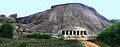 The Villapakkam Jain Rock Cut Cave
References
- ^ "Census of India 2001: Data from the 2001 Census, including cities, villages and towns (Provisional)". Census Commission of India. Archived from the original on 16 June 2004. Retrieved 1 November 2008.
12°51′43″N 79°17′32″E / 12.86194°N 79.29222°E
This article related to a location in Vellore district, Tamil Nadu, India is a stub. You can help Wikipedia by expanding it. |