
Vršič Pass
| Vršič Pass | ||
|---|---|---|
Elevation 1,611 m (5,285 ft) | | |
| Traversed by | Ruska cesta | |
| Location | Upper Carniola, Slovenia | |
| Range | Julian Alps | |
| Coordinates | 46°26′8″N 13°44′40″E / 46.43556°N 13.74444°E | |
 Vršič Pass Location of the Vršič Pass | ||
The Vršič Pass (pronounced
Name
The Slovene common noun vršič literally means 'little peak', a diminutive form of the word vrh 'peak'. The name originally referred to Mount Vršič (1,738 m or 5,702 ft), located about 200 m (660 ft) east of the Vršič Pass. The name Vršič was not applied to the pass until 1911. The name of the peak was first attested in written sources as Werschez in 1763–87. Locally, the pass is known as Na močilu (first attested in 1763–87 as Muschizach or Mushizhach).[4] The Italian name of the pass was Moistrocca.
History
This section needs expansion. You can help by adding to it. (October 2015) |
After World War I, from 1918 to World War II, the Vršič Pass was on the border between Italy and Yugoslavia. Since 1945, together with the Upper Isonzo Valley north of Gorizia, it was incorporated in Yugoslavia, and then in Slovenia.
Hiking
The Vršič Pass is considered an excellent starting point for excursions to surrounding peaks, including Mala Mojstrovka (2,332 m or 7,651 ft), Velika Mojstrovka (2,366 m or 7,762 ft), Planja (2,453 m or 8,048 ft), Prisojnik (Prisank) (2,547 m or 8,356 ft), Razor (2,601 m or 8,533 ft), Šitna Glava (2,087 m or 6,847 ft), Slemenova Špica (1,911 m or 6,270 ft), Sovna Glava (1,750 m or 5,740 ft), and Suhi Vrh (2,109 m or 6,919 ft), or shorter hikes in the immediate area.
Several mountain lodges are located near the pass: the Erjavec Lodge (Erjavčeva koča; 1,515 m or 4,970 ft), the Tičar Lodge (Tičarjev dom; 1,620 m or 5,310 ft), Mike's Lodge (Mihov dom), the Forest Lodge (Koča na Gozdu; 1,226 m or 4,022 ft), and the Postman's Lodge (Poštarska koča; 1,725 m or 5,659 ft).
Road
The road through the pass rises from
Monuments
Just off the main road, on the north side of the pass, at an elevation of around 1,200 m (3,900 ft), there is a
On the south side of the pass there is a bronze monument in honor of the mountaineer and writer Julius Kugy, work by the architect Boris Kobe and the sculptor Jakob Savinšek. It was erected in 1953.[6]
Gallery
-
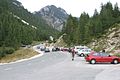 The Vršič Pass
 -
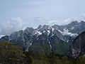 View from the Vršič Pass
 -
 Ascending the road to the Vršič Pass, view of the 23rd switchback at 1,539 m above sea level
 -
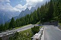
 The Russian Road; the switchbacks are paved with setts


See also
References
- ISBN 978-1-741-04856-8.
- ISBN 978-961-90906-8-8.
Čez prelaz Vršič ... je že od nekdaj vodila pot.
- ISSN 0023-4923.
- ^ Snoj, Marko. 2009. Etimološki slovar slovenskih zemljepisnih imen. Ljubljana: Modrijan and Založba ZRC, p. 470.
- ^ Nadbath, Barbara; Mlekuž, Dimitrij; Boštjančič, Janko, eds. (2018). Vojni ujetniki carske Rusije v prvi svetovni vojni na slovenskem ozemlju [Prisoners of War of Tsarist Russia in the First World War on Slovenian Territory] (PDF) (in Slovenian). p. 101, 111.
- ^ "4461: Trenta - Spomenik Juliusu Kugyju" [4461: Trenta – Monument to Julius Kugy]. Register nepremične kulturne dediščine [Registry of Immovable Cultural Heritage] (in Slovenian). Ministrstvo za kulturo Republike Slovenije. Retrieved 16 June 2015.
External links
- Vršič Road at Google Street View. VR panorama by Google.
| Settlements | Administrative seat: Bovec
|  | ||||
|---|---|---|---|---|---|---|
| Landmarks |
| |||||
| Notable people | ||||||
| Settlements | Administrative seat: Kranjska Gora
|  | ||||
|---|---|---|---|---|---|---|
| Landmarks | ||||||
| Notable people | ||||||
| International | |
|---|---|
| National | |