
Waiotapu

Waiotapu (
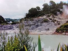
mud pools.[2] These can mostly be viewed through access by foot, and in addition to a paid and curated experience, naturally forming hot springs appear around the area. The geothermal area covers 18 square kilometres.[1] Prior to European occupation the area was the homeland of the Ngati Whaoa tribe who descended from those on the Arawa waka
(canoe).
The area has a long history as a tourist attraction. While the area has been protected as a scenic reserve[3] since 1931, a tourist operation occupies part of the reserve under a concession. It operates under the name "Wai-O-Tapu Thermal Wonderland".[4] The business was bought in 2012 by Te Arawa Group Holdings, a local Maori tribal business, from the Sewell/Leinhardt family, who had run it for 30 years.[5]
New Zealand State Highway 38 begins at Waiotapu and runs south-east through Kaingaroa Forest to Murupara
.
Gallery
-
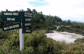
 Echo Lake
 -
 Central Pools
 -
 Lake Ngakoro Waterfall
 -
 Lake Ngakoro
 -
 Artist's Palette
 -
 Lady Knox Geyser erupting
 -
 Artist's Palette
 -
 Water pond made yellow by sulfur


.jpg)


See also
References
- ^ a b "Waiotapu Thermal track". Department of Conservation. Retrieved 27 December 2012.
- ^ "Guide to New Zealand Geothermal Attractions at Waiotapu". USAVE. Retrieved 13 May 2015.
- ^ "Waiotapu". Waikato Regional Council. Retrieved 27 December 2012.
- ^ "Waiotapu Thermal Wonderland, New Zealands most colourful geothermal area". waiotapu.co.nz. Retrieved 4 February 2014.
- ^ Macfarlane, Kristin (3 November 2012). "Te Arawa buys major thermal tourism park". The Daily Post. Retrieved 27 December 2012.
External links
Wikimedia Commons has media related to Waiotapu.