
Warneford Meadow
This article needs additional citations for verification. (June 2014) |

Warneford Meadow is an area of 20 acres (8.1 ha) of natural grassland immediately south-east of the Warneford Hospital, in Headington, east Oxford, England. The Warneford Meadow is a wild space within urban Oxford. The area has been used by local residents as a public space for recreation for over 50 years.[1]
History
Warneford Meadow was purchased in 1918 by the
Geography

Access to the Meadow is gained from either a lane off Hill Top Road, beside the Southfield Park Golf Club, or Roosevelt Drive opposite the 'Little Oxford' housing development (beside the Headington Care Home). The Meadow slopes gradually down from the Hill Top Road end, towards the Boundary Brook, which runs between the Meadow and the Churchill Hospital to the East. Several public paths run across the Meadow. South of the Meadow is the Southfield Park Golf Club and the Meadow is bounded to the west by homes on Hill Top Road. Warneford Meadow also includes an orchard, on the northern border of the Meadow with the Warneford Hospital.
Biodiversity
The Meadow contains species of
Development

Development of the Meadow is permitted under the Oxford Local Plan 2001–2016.
The plans for development met with substantial opposition from local residents, led by nearby Residents Associations and the action group 'Friends of Warneford Meadow'.[citation needed]
An application to have the land registered as a Town or Village Green (under section 22 of the Commons Registration Act 1965, amended by section 98 of the Countryside and Rights of Way Act 2000).[9] was launched in December 2006.[1] The application was successful, and Warneford Meadow was designated as a Town Green in April 2009.[10] Oxfordshire and Buckinghamshire Mental Health NHS Foundation Trust challenged the decision in the High Court;[11] the action commenced in February 2010. In March 2010 the High Court upheld the original decision to register the meadow as a Town Green.[12]
Gallery
-
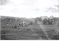 Boundary Brook and surrounding fields at around the time the Meadow became part of the Warneford Hospital.
 -
 Lye Valley near the Meadow during the same time period.
 -
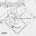 Warneford Hospital map from 1899, the Meadow is just to the south-east of the Hospital.


References
- ^ a b "Warneford Meadow to become Town Green?". 24dash.com. 21 December 2006. Retrieved 7 June 2014.
- ^ Headington News website describing the history of Warneford Hospital.
- ^ "NHS dilutes its 'student village' plan". Oxford Times. 29 December 2006. Retrieved 30 March 2010.
- ^ An Oxford City council planning document (pdf) discussing the archeological findings.
- ^ Oxford Local Plan 2001–2016
- ^ "Update on planning applications". Oxfordshire and Buckinghamshire Mental Health NHS Foundation Trust. 20 November 2007. Retrieved 30 March 2010.
- ^ Theyworkforyou.com – Liam Byrne MP clarifying the most valuable assets owned by the Department of Health.
- ^ Headington News website with details of the planning proposals submitted to Oxford County Council, 2006.
- ^ UK government/DEFRA website outlining legislation on Town or Village greens
- ^ Meadow Protected From Developers, BBC News, 6 April 2009. Retrieved 23 August 2009.
- ^ NHS to appeal on Oxford meadow being a "town green", Oxford Mail, 8 June 2009. Retrieved 23 August 2009.
- ^ "Meadow campaigners celebrate a new dawn". Oxford Mail. 24 March 2010. Retrieved 25 March 2010.
External links
- Additional information
- CPRE Oxfordshire – on Warneford Meadow
- The Open Space Society – a UK conservation society supporting the Town Green application
- Headington News website on Warneford Meadow
- The history of the adjoining Warneford Hospital
- The OBMH – outlining their position, 20 November 2007
- The Oxford County Council Local Plan