
Wells, Maine
Wells, Maine | ||
|---|---|---|
 Town Hall | ||
|
FIPS code 23-81475 | | |
| GNIS feature ID | 0582799 | |
| Website | www.wellstown.org | |
Wells is a
History

The Abenaki Indians called the area Webhannet, meaning "at the clear stream", a reference to the Webhannet River.
Edmund Littlefield, an immigrant from the wool regions of Titchfield, England, built the first gristmill and later a woolen mill on the Webhannet River, becoming known as "The Father of Wells," where a monument commemorates his contribution. In 1622, the
Wells was the resilient northeastern
Many early Wells settlers joined the Continental Army; some became Revolutionary War heroes, including Captains Samuel Gooch, Nathanial Littlefield, and Jeremiah Storer. Ocean View Cemetery on Post Road contains a Civil War monument and plot honoring its service members. Visitors can walk to Founder's Park just off of Post Road onto Sanford Road, which includes a light walking trail, picnic area, and the first settlement home. Monuments list the names of Wells' founding families.
The town developed as a
Wells celebrated its 350th anniversary in 2003.[7] The year-long celebration included a New Year's Eve party with fireworks, parade, a visit by the traveling Russian circus, concerts, historical reenactments, and more. The town commissioned a member of the celebration committee, Kristi Borst, to design a town flag. Her design portrays historic aspects of the Town's settlement and agriculture as well as the 2003 Town Hall and focus on tourism represented by a train. Also included is the motto she penned for the project: "Proud of our Past, Ready for our Future".[8]
Geography
Wells is on the southern coast of Maine, surrounded by Kennebunk to the northeast, Sanford to the northwest, North Berwick to the west, South Berwick to the southwest, and Ogunquit to the south.
According to the United States Census Bureau, the town has a total area of 73.61 square miles (190.65 km2), of which 57.55 square miles (149.05 km2) is land and 16.06 square miles (41.60 km2) is water.[1] Wells is drained by the Webhannet River. The highest point in town is an unnamed hill located one-half mile south of the intersection of State Route 9 and Bragdon Road, which is 360 feet (110 m) above sea level. The lowest elevation is sea level, along the coastline with the Atlantic Ocean.
Wells is part of the
-
 Wells Town Hall in 1911.
 -
 Wells Town Hall in the 1940s.


Transportation

There are several transportation corridors connecting Wells with other communities:
- Maine TurnpikeExit 19)
- U.S. Route 1
- Maine State Route 9
- Maine State Route 9A
- Maine State Route 109
- The Boston & Maine Railroad)
- The Eastern Trail, a multi-use trail, part of the East Coast Greenway
Access to the Amtrak national passenger rail system is available at the Wells Regional Transportation Center, which is served by 10 Downeaster trains per day. The center has a park and ride lot and is adjacent to the I-95 interchange.
Education
This section needs expansion. You can help by adding to it. (July 2011) |

There are four educational institutions in Wells: Wells Elementary School (kindergarten through fourth grade), Wells Junior High School (fifth grade through eighth grade), Wells High School (ninth grade through twelfth grade, as well as adult education programs), and York County Community College.
Wells is a member of the Wells-Ogunquit Community School District.
Places of worship

Baptist
- Highpine Baptist Church
- Wells Branch Baptist Church
Christian, interdenominational
- Shores Church
- Messiah Christian Church
Church of the Nazarene
- Lighthouse Church of the Nazarene
Pentecostal
- Mount Zion Chapel
Roman Catholic
- Saint Mary's Church
Old Catholic
- St. Francis of Assisi
United Church of Christ
- Congregational Church of Wells
Points of interest


- Seven miles of beaches: Drakes Island Beach, East Shore Beach, Wells Beach, and Moody Beach.
- The "Antiques Mile": – dozens of antiques vendors lining Post Road between Wells Corner and the Wells/Kennebunk town line.[9]
- Division 9 Schoolhouse Museum
- Historical Society of Wells & Ogunquit: Meetinghouse Museum & Library – located on the premises of what was originally the First Congregational Church of Wells
- Maine Diner
- Rachel Carson National Wildlife Refuge
- Wells Farmers' Market
- Wells Harbor Community Park
- Wells Harbor Summer Concert Series
- Wells National Estuarine Research Reserve and Historic Laudholm Farm
- Wells Public Library[10]
- Wonder Mountain Fun Park
Notable people
This article's list of residents may not follow Wikipedia's verifiability policy. (July 2016) |


- George Burroughs, clergyman, victim of the Salem witch trials
- Kathleen Chase, Maine state representative
- Ronald F. Collins, Maine state senator
- Jonathan Courtney, Maine state senator
- Nate Dingle, NFL football player[11]
- Daniel W. Gooch, US congressman
- Ivory Kimball, judge
- Steve Lavigne, comic book illustrator
- Nathaniel Littlefield, U.S. congressman; captain, Revolutionary War, Coast Guard at Wells and Kittery
- Ryan Peters (stage name Spose), rapper
- John Fairfield Scamman, US congressman
- John Storer, founder of Storer College
- Guy Tripp, Business executive and U.S. Army brigadier general[12]
- Esther Wheelwright, Mother Superior of the Ursuline order in Quebec City
- John Wheelwright, clergyman, original settler of Wells
Demographics
| Census | Pop. | Note | %± |
|---|---|---|---|
| 1790 | 3,070 | — | |
| 1800 | 3,692 | 20.3% | |
| 1810 | 4,489 | 21.6% | |
| 1820 | 2,660 | −40.7% | |
| 1830 | 2,978 | 12.0% | |
| 1840 | 2,978 | 0.0% | |
| 1850 | 2,945 | −1.1% | |
| 1860 | 2,878 | −2.3% | |
| 1870 | 2,773 | −3.6% | |
| 1880 | 2,450 | −11.6% | |
| 1890 | 2,029 | −17.2% | |
| 1900 | 2,007 | −1.1% | |
| 1910 | 1,908 | −4.9% | |
| 1920 | 1,943 | 1.8% | |
| 1930 | 2,047 | 5.4% | |
| 1940 | 2,144 | 4.7% | |
| 1950 | 2,321 | 8.3% | |
| 1960 | 3,528 | 52.0% | |
| 1970 | 4,448 | 26.1% | |
| 1980 | 8,211 | 84.6% | |
| 1990 | 7,778 | −5.3% | |
| 2000 | 9,400 | 20.9% | |
| 2010 | 9,589 | 2.0% | |
| 2020 | 11,314 | 18.0% | |
| [13][14][15] | |||
2010 Census
As of the
There were 4,120 households, of which 24.5% had children under the age of 18 living with them, 54.6% were married couples living together, 8.1% had a female householder with no husband present, 3.6% had a male householder with no wife present, and 33.6% were non-families. Of all households, 26.2% were made up of individuals, and 11.4% had someone living alone who was 65 years of age or older. The average household size was 2.30 and the average family size was 2.77.
The median age in the town was 48.5 years. 18.6% of residents were under the age of 18; 5.4% were between the ages of 18 and 24; 20.2% were from 25 to 44; 34.8% were from 45 to 64; and 21% were 65 years of age or older. The gender makeup of the town was 48.3% male and 51.7% female.
2000 Census
As of the
There were 4,004 households, out of which 25.6% had children under the age of 18 living with them, 57.7% were married couples living together, 6.7% had a female householder with no husband present, and 32.8% were non-families. Of all households, 26.3% were made up of individuals, and 11.0% had someone living alone who was 65 years of age or older. The average household size was 2.35 and the average family size was 2.85.
In the town, the population was spread out, with 21.0% under the age of 18, 5.6% from 18 to 24, 26.4% from 25 to 44, 30.2% from 45 to 64, and 16.9% who were 65 years of age or older. The median age was 43 years. For every 100 females, there were 94.8 males. For every 100 females age 18 and over, there were 92.0 males.
The median income for a household in the town was $46,314, and the median income for a family was $53,644. Males had a median income of $39,682 versus $28,463 for females. The
Images
-
 Wells High School
 -
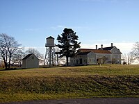
 One of Wells' many one-room schools, preserved as a museum.
 -
 Sign at town hall
 -
 Freight train at Wells Industrial Park
 -
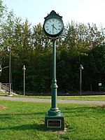 Memorial clock near train station
 -

-
-
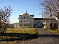
 Laudholm main building
 -
 First Parish Unitarian-Universalist Church, Kennebunk, built in 1749 when Kennebunk was still part of Wells.
 -
 Boat landing in 1916
 -
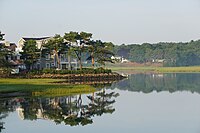 Ogunquit River in Moody, 2016
.jpg)


_2011.jpg)


References
- ^ a b "US Gazetteer files 2010". United States Census Bureau. Retrieved December 16, 2012.
- ^ Geo. J. Varney. "History of Wells, Maine." A Gazetteer of the State of Maine, Published by B. B. Russell, 57 Cornhill, Boston 1886. Transcribed by Betsey S. Webber.
- ^ "Census - Geography Profile: Wells town, York County, Maine". Retrieved January 11, 2022.
- ^ "America and West Indies: December 1661." Calendar of State Papers Colonial, America and West Indies: Volume 5, 1661-1668. Ed. W Noel Sainsbury. London: Her Majesty's Stationery Office, 1880. 61-66. British History Online[permanent dead link] Retrieved 4 March 2019.
- ^ a b Coolidge, Austin J.; John B. Mansfield (1859). A History and Description of New England. Boston, Massachusetts: A.J. Coolidge. pp. 349–353.
coolidge mansfield history description new england 1859.
- ^ Varney, George J. (1886), Gazetteer of the state of Maine. Wells, Boston: Russell
- ^ Hagan, Jennifer (January 1, 2004). "Kids Circus fitting finale for celebration". York County Coast Star. Retrieved July 27, 2010.
- ^ "Hope M. Shelley, "A History of Wells, Maine". Archived from the original on September 29, 2011. Retrieved January 28, 2011.
- ^ "10 things to do in Wells". Archived from the original on May 29, 2014. Retrieved May 28, 2014.
- ^ Wells Public Library
- ^ databaseFootball.com Archived November 22, 2011, at the Wayback Machine
- ISBN 978-1-5719-7088-6 – via Google Books.
- ^ "MAINE, Population of Counties by Decennial Census: 1900 to 1990". Archived from the original on February 1, 2016. Retrieved August 4, 2023.
- ^ "American FactFinder". Archived from the original on May 20, 2011. Retrieved October 1, 2011.
- ^ "University of Virginia Library". mapserver.lib.virginia.edu.
- ^ "U.S. Census website". United States Census Bureau. Retrieved December 16, 2012.
- ^ "U.S. Census website". United States Census Bureau. Retrieved January 31, 2008.
Further reading
- Wright, Virginia. "Shifting Sands: Wells". Down East: The Magazine of Maine (November 2007).
External links
- Town of Wells, Maine
- Wells Public Library
- Wells Chamber of Commerce
- Wells-Ogunquit Community School District
- York County Community College
- Maine Genealogy: Wells, York County, Maine
Municipalities and communities of York County, Maine, United States | ||
|---|---|---|
| Cities |  | |
| Towns | ||
| CDPs | ||
| Unincorporated communities and villages | ||
| Footnotes | ‡This populated place also has portions in an adjacent county | |
| ||
| International | |
|---|---|
| National | |