
Westerlo
This article needs additional citations for verification. (May 2022) |
Westerlo | |
|---|---|
 Town Hall of Westerlo | |
 Flag  Coat of arms | |
Location of Westerlo  | |
 Westerlo Location in Belgium
Westerlo municipality in the province of Antwerp CD&V | |
| Area | |
| • Total | 55.47 km2 (21.42 sq mi) |
| Population (2018-01-01)[1] | |
| • Total | 24,884 |
| • Density | 450/km2 (1,200/sq mi) |
| Postal codes | 2260 |
| NIS code | 13049 |
| Area codes | 014 - 015 - 016 |
| Website | www.westerlo.be |
Westerlo (Dutch pronunciation: Antwerp. The municipality comprises seven towns:
- Westerlo centrum
- Oevel
- Tongerlo
- Heultje
- Voortkapel
- Oosterwijk
- Zoerle-Parwijs
In 2021, Westerlo had a total population of 25,288.[2] The total area is 55.13 km2.
Places of interest
- neogothiccastle for herself which serves as the town hall of Westerlo since the 1970s.
- The Last Supper. It is also known as home of the Tongerlo Abbey beer, but this is no longer brewed at the abbey.
Gallery
-
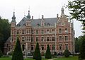 Westerlo, town hall
 -
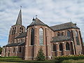
 Westerlo, church
 -
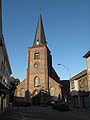
 Tongerlo, church
 -
 Oevel, church
 -
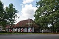 Hof van Overwijs


See also
References
- ^ "Wettelijke Bevolking per gemeente op 1 januari 2018". Statbel. Retrieved 9 March 2019.
- ^ "Bevolking per statistische sector - Sector 11035B". Statistics Belgium. Retrieved 11 May 2022.
External links
 Media related to Westerlo at Wikimedia Commons
- Official website (in Dutch)

| International | |
|---|---|
| National | |
| Geographic | |
| Other | |
This Antwerp Province location article is a stub. You can help Wikipedia by expanding it. |