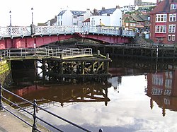
Whitby Swing Bridge
Whitby Swing Bridge | |
|---|---|
 Whitby Swing Bridge | |
| Coordinates | 54°29′13″N 0°36′46″W / 54.486914°N 0.612701°W |
| Crosses | River Esk, North Yorkshire |
| Characteristics | |
| Design | swing bridge |
| Longest span | 75 ft |
| Load limit | 7.5 tons[1] |
| History | |
| Designer | J Mitchell Moncrieff |
| Engineering design by | Heenan & Froude[2] |
| Construction start | 1908 |
| Construction cost | £22,582 (equivalent to £2,504,289 as of 2021),[3] |
| Opened | 1909 |
| Location | |
 | |
Whitby Swing Bridge is a pedestrian and road bridge over the River Esk in Whitby, North Yorkshire, England.
History
The
In 1629 an agreement was made by the justices in the North Riding to replace a wooden bridge with one which included moving parts. This was later replaced by a drawbridge, built in 1766 at a cost of £3,000 (equivalent to £444,000 in 2021), and later in 1835, the first swing bridge was opened designed by Francis Pickernell.[5][6]
Current bridge

By the early 20th century the limited 45-foot (14 m) clearance of the 1835 bridge was restricting the size of vessels which could be built upstream of the bridge. A replacement swing bridge was commissioned by
It was opened in July 1909 by Mabel Theresa Duncombe, the daughter of the Viscount of Helmsley and the wife of local MP, Sir Gervase Beckett. The bridge consists of two leaves moved independently by electric motors.[9]
The bridge originally carried the A171 road. To avoid congestion in the town centre, the road was diverted to a high level bridge over the Esk Valley built in 1980.
The bridge is not wide enough for vehicles to pass, so vehicular access to the bridge is controlled by traffic lights. The bridge is opened to shipping either side of high tide, but is quickly closed again to allow for traffic movement.
Until 2011 the bridge had a weight limit of 17 tons. This was reduced to 7.5 tons in 2011 by
In 2023 it was announced that the local council would be closing the bridge to traffic, with the exception of buses, during peak times in spring and summer. This was said to be to "address safety concerns around overcrowding".[10]
References
- ^ a b "Lower weight limit confirmed on Whitby swing bridge". North Yorkshire County Council. 18 May 2011. Archived from the original on 31 May 2012. Retrieved 25 June 2014.
- ^ a b The Electrical review: Volume 69. 1911
- ^ a b UK Retail Price Index inflation figures are based on data from Clark, Gregory (2017). "The Annual RPI and Average Earnings for Britain, 1209 to Present (New Series)". MeasuringWorth. Retrieved 11 June 2022.
- ^ History and topography of the city of York: and the North riding. T. Whellan and Co. 1859
- OCLC 6793956.
- OCLC 221940476.
- ^ Freeman, John. "Whitby Swing Bridge - Celebrating 100 Years of Whitby's Swing Bridge". Retrieved 2 November 2011.
- OCLC 749266990.
- ^ "Swing Bridge". www.heritagegateway.org.uk. Retrieved 6 July 2023.
- ^ "Whitby swing bridge to close to traffic in spring and summer". BBC News. 1 April 2023. Retrieved 3 April 2023.
