
Winchester, Adams County, Ohio
Winchester, Ohio | ||
|---|---|---|
FIPS code 39-85876 | | |
| GNIS feature ID | 2399711[2] | |
Winchester is a
State Route 136 passes through Winchester. Winchester is adjacent to Ohio State Route 32, a four lane divided highway known as the Appalachian Highway. The Appalachian Highway links Winchester to Cincinnati.
History
Winchester was laid out in 1815 by Joseph Darlinton. It was named for Darlinton's former hometown of Winchester, Virginia.[3]
There is also an
Geography
According to the United States Census Bureau, the village has a total area of 2.63 square miles (6.81 km2), of which 2.61 square miles (6.76 km2) is land and 0.02 square miles (0.05 km2) is water.[4]
Demographics
| Census | Pop. | Note | %± |
|---|---|---|---|
| 1870 | 416 | — | |
| 1880 | 550 | 32.2% | |
| 1900 | 796 | — | |
| 1910 | 927 | 16.5% | |
| 1920 | 913 | −1.5% | |
| 1930 | 821 | −10.1% | |
| 1940 | 798 | −2.8% | |
| 1950 | 690 | −13.5% | |
| 1960 | 788 | 14.2% | |
| 1970 | 760 | −3.6% | |
| 1980 | 1,080 | 42.1% | |
| 1990 | 978 | −9.4% | |
| 2000 | 1,025 | 4.8% | |
| 2010 | 1,051 | 2.5% | |
| 2020 | 987 | −6.1% | |
| U.S. Decennial Census[5] | |||
2010 census
As of the
There were 420 households, of which 34.0% had children under the age of 18 living with them, 45.7% were married couples living together, 13.1% had a female householder with no husband present, 6.2% had a male householder with no wife present, and 35.0% were non-families. 31.2% of all households were made up of individuals, and 13.3% had someone living alone who was 65 years of age or older. The average household size was 2.48 and the average family size was 3.05.
The median age in the village was 35.9 years. 27.3% of residents were under the age of 18; 9.3% were between the ages of 18 and 24; 25.9% were from 25 to 44; 22% were from 45 to 64; and 15.6% were 65 years of age or older. The gender makeup of the village was 49.0% male and 51.0% female.
2000 census
As of the
There were 410 households, out of which 34.9% had children under the age of 18 living with them, 52.4% were married couples living together, 11.0% had a female householder with no husband present, and 31.5% were non-families. 27.6% of all households were made up of individuals, and 13.7% had someone living alone who was 65 years of age or older. The average household size was 2.50 and the average family size was 3.06.
In the village, the population was spread out, with 28.4% under the age of 18, 8.7% from 18 to 24, 28.4% from 25 to 44, 20.3% from 45 to 64, and 14.2% who were 65 years of age or older. The median age was 34 years. For every 100 females, there were 89.1 males. For every 100 females age 18 and over, there were 85.4 males.
The median income for a household in the village was $32,344, and the median income for a family was $36,750. Males had a median income of $33,036 versus $19,028 for females. The
Gallery
-
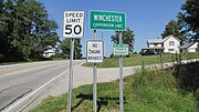 Winchester corporation limit sign
 -
 Looking north on Main Street (Ohio Highway 136) in Winchester
 -
 Winchester water tower
 -
 Fancy's Famous Pizza (now "Pop's Pizza")
 -
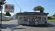 Reid's Dairy Bar (now "Winchester Dairy Bar")
 -
 Joseph Darlinton Bicentennial Marker
 -
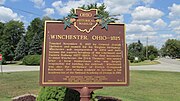 Winchester Ohio Historical Marker
 -
 Morgan's Raid 1863 (reverse side)
 -
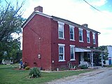 Dr. A. C. Lewis House


References
- ^ "ArcGIS REST Services Directory". United States Census Bureau. Retrieved September 20, 2022.
- ^ a b U.S. Geological Survey Geographic Names Information System: Winchester, Adams County, Ohio
- ^ Evans, Nelson Wiley (1900). A History of Adams County, Ohio: From Its Earliest Settlement to the Present Time. E B. Stivers. p. 498.
- ^ "US Gazetteer files 2010". United States Census Bureau. Retrieved January 6, 2013.
- ^ "Census of Population and Housing". Census.gov. Retrieved June 4, 2015.
- ^ "U.S. Census website". United States Census Bureau. Retrieved January 6, 2013.
- ^ "U.S. Census website". United States Census Bureau. Retrieved January 31, 2008.
 | ||||
| Townships | ||||
| CDPs | ||||
| Other communities | ||||
| ||||
| International | |
|---|---|
| National | |