
Withington Wilderness
| Withington Wilderness | |
|---|---|
Magdalena, NM | |
| Coordinates | 33°53′46″N 107°27′32″W / 33.896°N 107.459°W[1] |
| Governing body | U.S. Forest Service, Cibola National Forest |
| www | |
The Withington Wilderness is a 19,000-acre designated Wilderness area located within the Cibola National Forest in western New Mexico.[2] Located in the Magdalena Ranger District, approximately 20 miles southwest of Magdalena, New Mexico, the wilderness area lies around 10,100 ft. Mount Withington, on the eastern slope of the San Mateo Mountains in Socorro County, New Mexico, United States.
History and Administration
The Withington Wilderness Area was designated in December 1980 as part of Public Law 96-550, which placed numerous areas in New Mexico’s National Forests in the National Wilderness Preservation System. Also known as the New Mexico Wilderness Act, the law created two Wilderness Areas in the
Geography and Climate
The topography in the northern San Mateo Mountains is gentler than that in the south, but still features deep canyons, high ridgelines and generally dry conditions. Winters are cold enough to bring snow, and during July and August, the desert "monsoon" season, rainwater may flood narrow canyons.[5]
Flora
Vegetation within the Wilderness Area ranges from mixed conifers, such as pine, spruce, fir, in the higher elevations, to pinion and juniper in the more open ground east of the mountains, to stands of ocotillo along the western banks of the Rio Grande.[2]
Fauna
Habitats in the Withington Wilderness support populations of
-
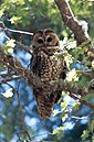 The Withington Wilderness contains critical habitat for the threatened Mexican spotted owl.
 -
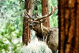 The Withington Wilderness is home to healthy populations of elk.
 -
 A black bear in Cibola National Forest.
 -
 A mule deer fawn in the snow.


Location and Access

In common with all designated Wilderness Areas, the Withington Wilderness is undeveloped and is closed to all forms of mechanized transport. A little visited area, particularly in comparison to the nearby Apache Kid Wilderness, the Wilderness can be accessed for hiking and Leave-No-Trace primitive camping via two trail-heads on the eastern border of the Wilderness. These trail-heads offer access to a pair of trails that traverse the area east-to-west, the 4.4 mile Trail 437, The Water Canyon Trail and the 6.2 mile Trail 438, The Potato Canyon Trail. Both trail-heads can be reached from Magdalena by traveling south on NM 107 for approximately 18 miles, before turning west onto Forest Road 52 and going three miles before turning south onto Forest Road 56. The trail-head for the Potato Canyon Trail is 2.5 miles from the junction with Forest Road 52 and the Water Canyon Trail trail-head is 6.5 miles, near the gated end of Forest Road 56. [7]
Nearby Attractions
The 8,039-acre White Cap Inventoried Roadless Area is directly adjacent to the Withington Wilderness. The Apache Kid Wilderness, also in the San Mateo Mountains, lies due south of the Withington Wilderness. To the north of the Withington Wilderness and San Mateo Mountains is the Very Large Array radio telescope observatory.
See also
- Cibola National Forest
- List of U.S. Wilderness Areas
References
- ^ "Withington Wilderness". Lat-long.com.
- ^ a b "Withington Wilderness". Wilderness.net.
- ^ "Wilderness Connect". wilderness.net.
- ^ "Cibola National Forest and National Grasslands - Districts".
- ^ "Cibola's Four Wilderness Areas". Cibola National Forest.
- ^ The Nature Conservancy (2004). Chapter 10: Ecological & Biological Diversity of the Cibola National Forest, Mountain Districts in Ecological and Biological Diversity of National Forests in Region 3.
- ^ "INTRODUCTION - SAN MATEO MOUNTAINS" (PDF). Retrieved 2023-10-01.
External links
- Cibola National Forest official website
- Socorro County InfoNet
- New Mexico Game and Fish
- Bear Trap Campground
- Hughes Mills Campground
- Ungnade, H. E. 1972. Guide to the New Mexico Mountains. University of New Mexico Press.
- Juylan, R. 1999. New Mexico's Wilderness Areas: The Complete Guide. Westcliff Pub Inc.
| Authority control databases: National |
|---|