Wolfgarten
Appearance
Wolfgarten | |
|---|---|
Stadtteil of Schleiden | |
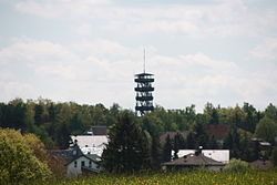
 Wolfgarten and its old fire watchtower | |
| Coordinates: 50°35′25″N 6°29′34″E / 50.5903°N 6.4928°E | |
| Country | Germany |
| State | North Rhine-Westphalia |
| Town | Schleiden |
| Elevation | 511 m (1,677 ft) |
| Population (2021)[1] | |
| • Total | 195 |
| Time zone | UTC+01:00 (CET) |
| • Summer (DST) | UTC+02:00 (CEST) |
| Postal codes | 53937 |
| Dialling codes | 02444 |
Wolfgarten is a village in the north of the borough of Schleiden in the Eifel mountains in the county of Euskirchen in the German state of North Rhine-Westphalia. The village has a population of about 195.[1]
Location
Wolfgarten lies in the
viewing tower until it collapsed in a fire on 13 June 2017. On the northeastern and eastern edge are the forester's lodges
of Mariawald and Wolfgarten respectively.
History
Wolfgarten was founded around 1470 as an emphyteutic estate (Erbpachthof) under the suzerainty of Jülich, and is the place of origin of the family of Wolfgarten, who also spell their name "Wolffgarten".
In the early 19th century, Wolfgarten belonged to the French-occupied mairie of Gemünd.
In accordance with § 9 of the 1971 Aachen Act, the village was incorporated into the new borough of Schleiden on 1 January 1972.[2]
Transport
The
L 249 runs through Wolfgarten. Its nearest motorway junctions are Bad Münstereifel / Mechernich on the A 1 and Aachen-Lichtenbusch on the A 44
.
References
- ^ a b Bevölkerungsstatistik, Stadt Schleiden, accessed 24 September 2021.
- ISBN 3-17-003263-1. record.


