
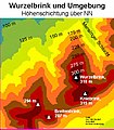
Wurzelbrink
| Wurzelbrink | |
|---|---|
 View of the Wurzelbrink from Reineberg | |
| Highest point | |
| Elevation | 318 m above sea level (NN) (1,043 ft) |
| Coordinates | 52°16′58″N 8°36′54″E / 52.28278°N 8.6151278°E |
| Geography | |
 Wurzelbrink | |
| Parent range | Wiehen Hills |
The Wurzelbrink is a hill south of Lübbecke which, at 318 m above NN, is the second highest peak in the Wiehen Hills in north Germany. Immediately to the south is the no less majestic Kniebrink (315 m). There is an old and rather small watchtower, the Wartturm, on top of the Wurzelbrink, which was built in 1857, whose outstanding views of the local area are partly obscured by the trees that have now grown up around it.
Views
Towards the east the "King of the Wiehen Hills", the
The Mensinger Ravine begins on the eastern side of the hill and runs northwards.
It is worth noting that if the tower were raised by a few metres, as has been done for the neighbouring observation tower on the Nonnenstein, it would afford the hiker clear views again.
Spring on the Wurzelbrink
On the western slope of the hill, a spring rises immediately next to a hiking trail. The spring has been comprehensively walled in. Occasionally you can see the locals fill cans and other containers on carts here, with this apparently very drinkable source of water, for their domestic use. In the springtime the source yields 10 litres of water per minute. In summer, the yield can drop to more or less nothing, however, depending on the weather. So far the source has not been given any legally binding name. However, local residents have for decades called it, jocularly, the Mickey Mouse Spring. According to unofficial chemical analysis the spring water generally has very low levels of pollutants. Only the proportion of copper ions is relatively high for human consumption but this use is still safe.
Gallery
-
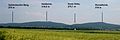 The Wurzelbrink (far right) seen from the north
 -
 From Lübbecke it takes 45–60 minutes to climb the Wurzelbrink
 -
 On the northwestern flank of the Wurzelbrink a clearing enables a view of the Lübbecke Land.
 -
 The watchtower (Wartturm) on the summit of the Wurzelbrink
 -
 Next to the Wurzelbrink the Kniebrink also rises above the 300 metre mark
 -
 A stream source on the western slope of the Wurzelbrink
 -
 Memorial tablet on the tower


