
Yuba, Wisconsin
Yuba, Wisconsin | ||
|---|---|---|
FIPS code 55-89625[5] | | |
| GNIS feature ID | 1577119[2] | |
Yuba is a village in
-
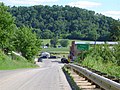
 South of Yuba, looking north
 -
 Inside St. Wenceslaus Church
 -
 North of Yuba (population 77), looking south
 -
 Frank and Sophie's Farm, just north of Yuba


Geography
Yuba is located at 43°32′20″N 90°25′38″W / 43.53889°N 90.42722°W (43.538917, -90.427169).[6]
According to the United States Census Bureau, the village has a total area of 0.30 square miles (0.78 km2), all of it land.[7]
Demographics
| Census | Pop. | Note | %± |
|---|---|---|---|
| 1940 | 116 | — | |
| 1950 | 119 | 2.6% | |
| 1960 | 91 | −23.5% | |
| 1970 | 79 | −13.2% | |
| 1980 | 72 | −8.9% | |
| 1990 | 77 | 6.9% | |
| 2000 | 92 | 19.5% | |
| 2010 | 74 | −19.6% | |
| 2019 (est.) | 69 | [4] | −6.8% |
| U.S. Decennial Census[8] | |||
2010 census
As of the
There were 33 households, of which 24.2% had children under the age of 18 living with them, 48.5% were married couples living together, 12.1% had a female householder with no husband present, 6.1% had a male householder with no wife present, and 33.3% were non-families. 30.3% of all households were made up of individuals, and 6.1% had someone living alone who was 65 years of age or older. The average household size was 2.24 and the average family size was 2.73.
The median age in the village was 40.5 years. 21.6% of residents were under the age of 18; 9.5% were between the ages of 18 and 24; 23% were from 25 to 44; 28.4% were from 45 to 64; and 17.6% were 65 years of age or older. The gender makeup of the village was 51.4% male and 48.6% female.
2000 census
As of the
There were 32 households, out of which 34.4% had children under the age of 18 living with them, 68.8% were married couples living together, 3.1% had a female householder with no husband present, and 25.0% were non-families. 18.8% of all households were made up of individuals, and 9.4% had someone living alone who was 65 years of age or older. The average household size was 2.88 and the average family size was 3.29.
In the village, the population was spread out, with 30.4% under the age of 18, 7.6% from 18 to 24, 22.8% from 25 to 44, 21.7% from 45 to 64, and 17.4% who were 65 years of age or older. The median age was 37 years. For every 100 females, there were 91.7 males. For every 100 females age 18 and over, there were 93.9 males.
The median income for a household in the village was $34,063, and the median income for a family was $34,750. Males had a median income of $40,000 versus $20,313 for females. The
References
- ^ "2019 U.S. Gazetteer Files". United States Census Bureau. Retrieved August 7, 2020.
- ^ a b "US Board on Geographic Names". United States Geological Survey. October 25, 2007. Retrieved January 31, 2008.
- ^ a b "U.S. Census website". United States Census Bureau. Retrieved November 18, 2012.
- ^ a b "Population and Housing Unit Estimates". United States Census Bureau. May 24, 2020. Retrieved May 27, 2020.
- ^ a b "U.S. Census website". United States Census Bureau. Retrieved January 31, 2008.
- ^ "US Gazetteer files: 2010, 2000, and 1990". United States Census Bureau. February 12, 2011. Retrieved April 23, 2011.
- ^ "US Gazetteer files 2010". United States Census Bureau. Retrieved November 18, 2012.
- ^ "Census of Population and Housing". Census.gov. Retrieved June 4, 2015.
 | ||||
Villages | ||||
Towns | ||||
| CDPs | ||||
| Other communities |
| |||
| Former communities |
| |||
| Footnotes | ‡This populated place also has portions in an adjacent county or counties | |||
| ||||
| International | |
|---|---|
| National | |