
Zashchitnaya Bay
You can help expand this article with text translated from the corresponding article in Finnish. (June 2023) Click [show] for important translation instructions.
|

Zashchitnaya Bay (
Monrepos Park face Zashchitnaya Bay. The old Saimaa Canal (opened in 1856), as well as the new one, connect Zashchitnaya Bay with Lake Saimaa
in Finland.
In the Middle Ages, the river
: Taipaleenjoki) became the main outlet of Vuoksa.The Russian name of the bay is derived from the Russian word for
defense
and may be translated as "shielding".
-
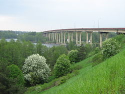 The Gvardeisky Strait (Bay of Vyborg to Zashchitnaya Bay. The present-day sailing route to Saimaa Canalruns below the bridge.
 -
 The other waterway from the Bay of Vyborg to Zashchitnaya Bay is Linnansalmi, in which theCastle of Vyborgis located. The old vessel route to Saimaa Canal up to the 1930s ran through Linnansalmi.


Sources
- Map
- a society conserving the park of Monrepos
- a map of Monrepos
- a Historical Study of the villages surrounding Suomenvedenpohja - bay
- a State treaty between Finland and the Soviet union about the Saimaa Canal mentioning location of the Canal in Suomenvedenpohja.
- a link to a picture From Suomenvedenpohja