
Zestafoni Municipality
Zestafoni Municipality
ზესტაფონის მუნიციპალიტეტი | |
|---|---|
 Tabakini Church near Argveti | |
|
UTC+4 (Georgian Standard Time) | |
 |
Zestafoni (Georgian: ზესტაფონის მუნიციპალიტეტი) is a municipality of Georgia, in the region of Imereti. The municipality covers a total area of 423 square kilometres and as of 2014 it had a population total of 57,628 people. Its main town is
Geography
The municipality to the west of the town of Zestafoni is part of the
The municipality is forested with hornbeam, oak, beech, chestnut, alder and many other tree species. The southern range has beech, maple, lime and Imeretian oak. The land has been partly cleared for agriculture in the lowlands and hilly areas, but is more densely forested in the southern mountain range. The forests are home to wolf, fox, jackal, badger, rabbit and smaller animals.[2]
Settlements
Towns
The town of Zestafoni and the smaller neighboring town of Shorapani are industrial centers. The Zestafoni ferro-alloy plant processes raw manganese ore shipped by rail down the Kvirila valley from Chiatura, supplying 6% of world demand. It is the largest ferroalloy plant in the country.[3] There were more factories in the Soviet era, but many have closed down.[2]
Rural areas
The rural areas include the communities of Boslevi, Dilikauri, Dzirula, Ilemi, Kldeeti, Kvaliti, Kveda Sakara, Kveda Sazano, Meore Sviri, Phuti, Pirveli Sviri, Rodinauli, Sanakhshire, Shrosha, Tskhratskaro, Zeda Sakara and Zovreti. Each community typically includes two or three villages. There are medieval castles in several villages, notably the Shorapani and Sviri castles in the historical village of Argveti and a castle from the 6th-7th centuries in Tabakini. There are old churches, ancient wine cellars and other points of interest for tourism.[2]
The Zestafoni Municipality has 5,000 hectares of vineyards accounting for 80% of all farmland. The Sakara Viticulture and Winemaking Scientific-Research Station plays an important role in developing viticulture in the Zestafoni Region. Other crops include maize and vegetables, cattle breeding and swine production.[2]
The district's main settlements are:
| Rank | Settlement | Population |
|---|---|---|
| 1 | Zestaponi | 20 814 |
| 2 | Zeda Sakara | 2 099 |
| 3 | Kveda Sakara | 1 989 |
| 4 | Puti | 1 564 |
| 5 | Zovreti | 1 513 |
| 6 | Shorapani | 1 258 |
Politics
Zestaponi Municipal Assembly (Georgian: ზესტაფონის საკრებულო, Zestaponis Sakrebulo) is a representative body in Zestaponi Municipality, consisting of 39 members which are elected every four years. The last election was held in October 2021.
| Party | 2017[4] | 2021[5] | Current Municipal Assembly | |||||||||||||||||||||||||||||||||||
|---|---|---|---|---|---|---|---|---|---|---|---|---|---|---|---|---|---|---|---|---|---|---|---|---|---|---|---|---|---|---|---|---|---|---|---|---|---|---|
| Georgian Dream | 29 | 27 | ||||||||||||||||||||||||||||||||||||
| United National Movement | 3 | 10 | ||||||||||||||||||||||||||||||||||||
| For Georgia | 2 | |||||||||||||||||||||||||||||||||||||
European Georgia
|
2 | |||||||||||||||||||||||||||||||||||||
| Alliance of Patriots | 2 | |||||||||||||||||||||||||||||||||||||
| Total | 36 | 39 | ||||||||||||||||||||||||||||||||||||
See also
Gallery
-
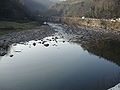 River near Shrosha, Zestafoni
 -
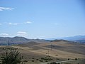 Landscape near Puti
 -
 Zestaponi railway station
 -
 Orthodox church in Zestafoni

.jpg)
.jpg)

References
- ^ "Ethnic composition of Georgia 2014". mashke.org. Archived from the original on 2018-11-04.
- ^ a b c d e f "Zestafoni Region". PS News. Archived from the original on July 21, 2011. Retrieved 2010-01-31.
- ^ MITCHELL, ROBERT W. (April 2, 1999). "Russia plans to up output of ferroalloys". American Metal Market. Retrieved 2009-02-01.[dead link]
- ^ "Protocol elected municipal council members and mayors 2017" (PDF) (in Georgian). CESKO Central Election Commission. Retrieved 2021-12-20.
- ^ "Protocol elected municipal council members and mayors 2021" (PDF) (in Georgian). CESKO Central Election Commission. Retrieved 2022-12-20.
External links
- Municipalities of Georgia, Statoids.com