
Zillertal

The Ziller Valley
The Ziller Valley is one of the valley areas in Tyrol most visited by tourists.[4] Its largest settlement is Mayrhofen.
Geography

The Ziller Valley branches from the Inn trench near
Unlike other side valleys of the Inntal, the Ziller Valley rises constantly, but only marginally, from one end to the other – only about 100 m over 30 km. Permanent settlements cover about 9% of the entire area of the Ziller Valley municipalities.
History
Near the
The earliest written record of the Ziller Valley dates from 889, when
In 1248, the land west of the Ziller was acquired by the
In 1805, the

While the relatively lenient stance of the archbishops of Salzburg had allowed the creation of small pockets of
In 1902, the
The Ziller Valley was known for its itinerant tradesmen, "farm doctors" and singing families. In the second half of the 19th century refuge huts were erected and trails established as climbing became a mass sport. The development of the area for tourism began in 1953/1954 with the construction of the Gerlosstein ski region, today the Zillertal Arena, which was soon followed by other lifts and the opening of the Mayrhofner Penkenbahn in 1954. The use of water power took off in the 1970s.
Economy
In the second half of the 20th century, after the end of mining in the valley, tourism became the area's dominant economic activity. In 2003, tourists stayed a total of 6 million nights in the valley, mostly during winter sports holidays. Following a phase of mergers by building connecting lifts during the 1990s and early 2000s, there are now four big ski areas, the largest of which is the Zillertal Arena, and three smaller satellite areas in the valley. Combined, they offer a total of more than 170 lifts and more than 630 km of downhill slopes.
Traditional agriculture – mostly cattle, dairy and some sheep farming on the Alm pastures – is still widespread and the large
Culture
The Ziller Valley is particularly renowned for its musical tradition. For instance, several families of travelling singers and organ builders from the valley have been credited with spreading the
Religion
Catholic Church
The majority of the population belongs to the Catholic Church, which plays an important role in socio-cultural life.[6]
Protestantism
After the
Gallery
-
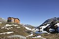
 Berliner Hütte
 -
 Neue Post in Mayrhofen
 -
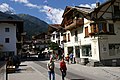 Mainstreet in Mayrhofen
 -
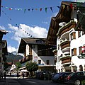 Mainstreet in Mayrhofen
 -
 Hintertux Glacier
 -
 Pfitscherjochhaus and the Jochsee


See also
References
- Newspapers.com.

- Newspapers.com.
- Newspapers.com.
- ^ a b "Zillertal". Encyclopedia of Austria. Retrieved 2 November 2013.
- ISBN 978-3-7030-0469-8
- ^ Salzburg 2016 - Warum die Kirchtürme im Zillertal grün und rot sind. Tiroler Tageszeitung, 2015.
- ^ Der geschichtliche Ablauf der Auswanderung aus dem Zillertal. In: 1837-auswanderer.de. Zillertaler Auswanderer 1837. Retrieved 11 October 2016.
- ^ Free Evangelical Church in Mayrhofen
- ^ Evangelical Church Jenbach
External links
- Zillertal website (Summer)
- Zillertal website (Winter)
- Rock climbing and bouldering in Zillertal
47°20′N 11°52′E / 47.333°N 11.867°E
| International | |
|---|---|
| National | |