
Abad Santos Avenue
N151 | |
|---|---|
| Location | Manila |
| North end | |
| Major junctions |
|
| South end | N145 (Recto Avenue ) |
Abad Santos Avenue is a major north–south arterial road located in the district of
Binondo
at the south.
History
Abad Santos Avenue was originally built in the early 19th century under
Japanese invading forces during World War II.[3]
Route
Abad Santos Avenue begins at a split from Rizal Avenue just south of Hermosa Street near the San Jose Manggagawa de Manuguit Church and the Manila Chinese Cemetery at Tondo's border with
Chiang Kai Shek College, the Philippine Cultural College, as well as General Hizon Elementary School and Gregorio del Pilar Elementary School. The road ends at the junction with Recto Avenue (Calle Azcarraga) close to the Divisoria
shopping district.
Abad Santos Avenue has a short extension into Binondo and Plaza San Lorenzo Ruíz south of Recto Avenue as Reina Regente Street. It is served by the Abad Santos station at Rizal Avenue.
Intersections
The entire route is located in Manila.
| km | mi | Destinations | Notes | ||
|---|---|---|---|---|---|
| Northern terminus. Traffic light intersection. Continues north as | |||||
| Morong Street | Unsignaled intersection. | ||||
| Dinalupihan Street | Northbound only. | ||||
| Corregidor Street | Southbound only. | ||||
| Solis Street | Traffic light intersection. | ||||
| Tecson Street | Traffic light intersection. | ||||
| Antipolo Street, Old Antipolo Street | Traffic light intersection. Railroad crossing. | ||||
| Batangas Street | Unsignaled intersection. | ||||
| Yuseco Street | Traffic light intersection. | ||||
N140 (Tayuman Street ) | Traffic light intersection. | ||||
| Villaruel Street | |||||
| Quiricada Street | Traffic light intersection. | ||||
| Bambang Street / Bambang Extension | Traffic light intersection. | ||||
| G. Araneta Street | Northbound only. | ||||
| Mayhaligue Street | Traffic light intersection. | ||||
| La Torre Street | |||||
| Padre Algue Street | Traffic light intersection. | ||||
N145 (Claro M. Recto Avenue ) | Southern terminus. Traffic light intersection. Continues southward as Reina Regente Street. | ||||
| 1.000 mi = 1.609 km; 1.000 km = 0.621 mi | |||||
Photos
-
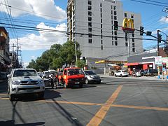 Bambang Street-Abad Santos Avenue intersection
 -
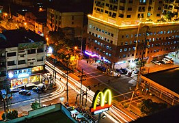 Bambang Street-Abad Santos Avenue intersection at night
 -
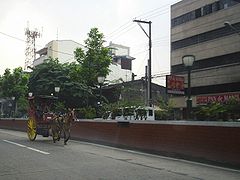 Calesaplying the avenue, near Quiricada Street-Abad Santos Avenue intersection


References
- ^ "North Manila". Archived from the original on June 6, 2020. Retrieved May 23, 2020.
- ^ "Andres Bonifacio: Biographical notes. Part I: 1863-1891 - Katipunan: Documents and Studies". www.kasaysayan-kkk.info. p. 10. Retrieved November 16, 2017.
... in the Tondo barrio of Palomar, which was situated on an estero-ringed island just to the east of Tutuban.
- ^ Republic Act No. 1256 (June 10, 1955), "An Act Changing The Name Of Manuguit Street, A National Highway In The City Of Manila, To Jose Abad Santos Street", LawCenter Philippines, archived from the original on December 19, 2013, retrieved May 16, 2020
| ||||||||||||||||||||||
| ||||||||||||||||||||||