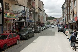
Akdağmadeni
Akdağmadeni | |
|---|---|
 | |
| Coordinates: 39°39′57″N 35°53′01″E / 39.66583°N 35.88361°E | |
| Country | Turkey |
| Province | Yozgat |
| District | Akdağmadeni |
| Government | |
| • Mayor | Nezih Yalçın (MHP) |
| Elevation | 1,344 m (4,409 ft) |
| Population (2022)[1] | 22,180 |
| Time zone | UTC+3 (TRT) |
| Postal code | 66540 |
| Area code | 0354 |
| Website | www |
Akdağmadeni (
Central Anatolia region of Turkey. It is the seat of Akdağmadeni District.[3] Its population is 22,180 (2022).[1] Its elevation is 1,344 m (4,409 ft).[4]
According to the
Roma.[5]
Most of the Armenians and Greeks were killed or expelled by 1923.
References
- ^ TÜİK. Retrieved 22 May 2023.
- ^ Γεώργιος Κλεάνθης Σκαλιέρης, Λαοί και φυλαί της Μικράς Ασίας. Μετά πινάκων και χαρτών. Athens (Typos) 1922, p. 42. Digitalized version
- ^ İlçe Belediyesi, Turkey Civil Administration Departments Inventory. Retrieved 22 May 2023.
- ^ Falling Rain Genomics, Inc. "Geographical information on Akdağmadeni, Turkey". Retrieved 9 June 2023.
- The University of Wisconsin Press, p. 172-173
External links
- District municipality's official website (in Turkish)


