
Alblasserwaard

The Alblasserwaard (Dutch pronunciation:
History


The first human inhabitants of the Alblasserwaard settled there after the last ice age, around 10.000 years ago. The ice had not reached the area itself, but eolian deposits created high points in the wet environment. These high points were places where hunter-gatherers settled, as archaeological investigations in the area have shown.
During the
During
It was flooded during the North Sea flood of 1953.
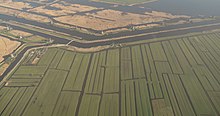
Geography and population
The Alblasserwaard is bordered by rivers on all sides. To the north is the
Most of the Alblasserwaard is rural, but, partially under the influence of the cities of Rotterdam and Dordrecht on the borders of the area, the south and west are urbanised.
The largest cities in the Alblasserwaard are Gorinchem, with 35,000 inhabitants, and Papendrecht with slightly over 30,000 people. Both are on the southern borders of the Alblasserwaard.
The municipalities in the Alblasserwaard are:
-
 Kinderdijk, several windmills
 -
 between Meerkerk and Ameide, ditch in the polder
 -
 between Ameide and Meerkerk, ditch in the polder


Geology
Extensive parts of the Netherlands are below sea level, and the Alblasserwaard is no different. Most of it has been wrestled from the water through land reclamation, using the windmills on the Kinderdijk. This process led to the area being full of dikes alongside the rivers. Most of the Alblasserwaard is grassland, where in the spring and summer one will find herds of cows, sheep and goats. The ground consists of clay.
Nature and recreation
While large parts of the Alblasserwaard are owned by farmers, or are populated, some areas are open to the public for recreation.
- The windmills of Kinderdijk are a major tourist attraction.
- In the southwest of the Alblasserwaard is the Alblasserbos, an artificial forest area where deer and foxes live, as well as numerous smaller species.
- Roughly between Streefkerk and Brandwijk is the area Donkse Laagten, which is under the protection of the Dutch government forestry authority Staatsbosbeheer.
- There are three free camping spots in the Alblasserwaard, as part of a project by Staatsbosbeheer to promote legal camping in the wild. These are located respectively in the Alblasserbos, the Donkse Laagten and the Avelingen.[3][4][5]
- The Lammetjeswiel is a recreational area within the village of Alblasserdam. It is a popular swimming area, with governmental checks of the water condition twice a month.[6]
References
- ^ Regt, Jacobus Wilhelmus (1848). Geschied- en Aardrijkskundige Beschrijving van den Zwijndrechtschen Waard, den Riederwaard en het Land van Putton Over de Maas. p. 143.
- ^ Zederik partly belongs to the region of Alblasserwaard and partly to the region of Vijfheerenlanden.
- ^ "Staatsbosbeheer on the Donkse Laagten free camping spot". Archived from the original on 2009-05-10.
- ^ "Staatsbosbeheer on the Alblasserbos free camping spot". Archived from the original on 2009-05-22.
- ^ "Staatsbosbeheer on the Avelingen free camping spot". Archived from the original on 2009-04-13.
- ^ "Official Alblasserdam Site about the Lammetjeswiel recreational area".[permanent dead link]
External links
| International | |
|---|---|
| National | |