
Anderson Peak (Placer County, California)
| Anderson Peak | |
|---|---|
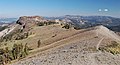
 North aspect | |
| Highest point | |
| Elevation | 8,683 ft (2,647 m)[1][2] |
| Prominence | 163 ft (50 m)[3] |
| Parent peak | Tinker Knob (8,949 ft)[4] |
| Isolation | 1.18 mi (1.90 km)[4] |
| Coordinates | 39°15′33″N 120°17′50″W / 39.2590339°N 120.2971744°W[5] |
| Geography | |
 Anderson Peak Location in California  Anderson Peak Anderson Peak (the United States) | |
| Country | |
Anderson Peak is an 8,683-foot-elevation (2,647 meter) mountain summit in Placer County, California, United States.
Description
Anderson Peak is located 4 miles (6.4 km) south-southeast of
U.S. Board on Geographic Names.[5]
Climate
According to the Köppen climate classification system, Anderson Peak is located in an alpine climate zone.[7] Most weather fronts originate in the Pacific Ocean and travel east toward the Sierra Nevada mountains. As fronts approach, they are forced upward by the peaks (orographic lift), causing them to drop their moisture in the form of rain or snowfall onto the range.
Gallery
-
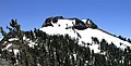
 Southeast aspect of Anderson Peak (left) seen from Pacific Crest Trail
 -
 North aspect, from PCT


See also
References
- ^ United States Geological Survey topographical map - Norden
- ^ ISBN 9781493036455, p. 43
- ^ a b "Anderson Peak, California". Peakbagger.com. Retrieved 2022-07-17.
- ^ a b c "Anderson Peak - 8,683' CA". listsofjohn.com. Retrieved 2022-07-17.
- ^ a b "Anderson Peak". Geographic Names Information System. United States Geological Survey, United States Department of the Interior. Retrieved 2022-07-17.
- ISBN 9780899973173, p. 136
- ^ "Climate of the Sierra Nevada". Encyclopædia Britannica.
External links
- Weather forecast: Anderson Peak
- National Geodetic Survey Data Sheet