
Anna Salai
| Mount Road | |
St.Thomas Mount, Chennai | |
| Major junctions | Pallavan Salai West Cooum River Road/Swami Sivananda Salai Wallaja Road/Blackers Road General Patters Road Binny Road/Spencers Plaza Whites Road/Greams Road Peters road Lloyds Road Nungambakkam High Road/Cathedral Road (Anna Flyover) Vijaya Raghava Road Sir Thyagaraya Road, T. Nagar/Eldams Road Cenotaph Road Venkatanarayana Road/Chamiers Road South Usman Road, T. Nagar Taluk Office Road, Velachery Main Road(Little Mount) Sardhar Patel Road Guindy Race Course Road Maduvankarai Bridge Road |
|---|---|
| North end | Flag Staff Road, Island Grounds, Chennai |

Anna Salai (Tamil:
Several flyover projects were under consideration on the road, many of which have been shelved owing to the construction of the Chennai Metro project, which runs along the median of the road.[3] Anna Salai Head Post office, one of the most important post offices in the city, is located on this road. It was established in 1854 as Mount Road SO as a non-gazetted delivery office. With the growth of commerce and urbanization, this SO was upgraded to gazetted in 1955. Nomenclature of this Head Post office was changed from Mount Road Head Post office to Anna Road Head Post office on 15 September 1974.
History

Anna Salai can be traced from at least the early 17th century,
In the 1700s, the road was lined with garden houses and large colonial mansions with balconies and verandas set amidst lush gardens.[6] By the 1800s, Mount Road has become the traders' area of the city of Madras while First Line Beach in Georgetown remained the seat of processing, shipping and manufacturing businesses. However, the business activities of Mount Road was responsible for the city's economic growth. Several giant firms had beginnings on Mount Road, from the Amalgamations group to the TVS group. The road's proximity to the Government House, the home of the Governor, and the palaces of the Nawabs of Arcot resulted in several firms selling cars and other luxury goods setting up shops on the road. Simpson & Co, which moved to its current location opposite Government Estate after 1875, began building carriages and coaches and then cars. In the early 1900s, the road became the entertainment hub for the British.[6] In 1903, the first steam-driven car was taken for its debut drive on Mount Road. To overcome the Great Depression of the 1930s, Simpon's introduced the hire purchase system for cars and trucks. In the 1930s, the TVS group, which was a travel operator in mofussil areas, was established in Madras by acquiring the Madras Auto Service property. In the 1940s, Anantharamakrishnan helped with the formation of Amalgamations & Co. The city's first skyscraper, the LIC Building, was built on Anna Salai in 1959. Several major firms were then established, namely, Spencers & Co, Victoria Family Hotel (the present location of the Indian Overseas Bank Headquarters) and Higginbothams.[1]
The Stretch
Anna Salai starts from the
By the 2010s, the stretch between
Safety level
Anna Salai remains the road in the city experiencing second most number of accidents annually, next only to Jawaharlal Nehru Road (100 ft Inner Ring Road), with one person being injured every 1.13 days. Together, these roads account for almost 14 per cent of the 5,101 accidents that occurred in Chennai in 2010.[9]
Landmarks on Anna Salai
Major landmarks
- Agurchand Mansion (built late 1800s)
- Anna Flyover
- Ashok Leyland - ALCOB Building
- Bharat Overseas Bank Headquarters
- Indian Overseas Bank Headquarters
- Bharat Insurance Building (built 1897)
- Century Plaza
- Christ Church (built 1852)
- Cosmopolitan Club
- Cosmopolitan Club Golf Links
- Pasumpon Thevar Statue
- American Consulate
- Devaneya Paavaanar Library
- Devi Theater
- Dravida Munnetra Kazhagam [DMK] (Party Headquarters)
- Gove House (built 1916)
- The Grand Chola Hotel
- Guindy Railway Overbridge
- Higginbotham's (India's oldest bookshop) (built 1844)
- Hindustan Teleprinters Limited (built early 1900s)
- Hyatt Regency Hotel
- Indian Oil Building
- Intellectual Property India Headquarters
- Island Grounds Exhibition Centre
- Kalignar Satellite Television Headquarters
- Kamaraj Memorial Hall
- Kathipara Cloverleaf Intersection
- Le Royal Meridien Hotel
- LIC Building (Chennai's first skyscraper)
- Madras Gymkhana Club
- Maraimalai Adigal Bridge
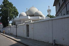
- Mount Road Mosque
- Thousand Lights Mosque (built early 1800s)
- Mount Road Head Post Office
- The Hindu
- The Mail (built 1921)
- Thevar Statue
- Oxford University Press
- P Orr & Sons (built 1873)
- Panagal Building
- The Park Hotel
- Poombuhar Building (built late 1800s)
- Rajaji Hall (built 1802)
- Raheja Towers
- Rani Seethai Hall
- Rayala Towers
- Sacred Heart School, Church Park
- Safire Theatre complex (now demolished)
- Saidapet Teachers' College
- Semmozhi Poonga
- Simpsons
- Spencer Plaza
- SPIC Building
- State Bank of India building (built early 1900s)
- St. George's Cathedral (built 1816)
- St. Thomas Mount
- Sterling Towers
- Taj Connemara Hotel
- Tamil Nadu Electricity Board Headquarters
- Tamil Nadu Legislative Assembly Government Estate
- Tamil Nadu Newsprint and Papers Limited (TNPL)
- Tamil Nadu Pollution Control Board
- Tarapore Towers
- The British Council
- VGP Victory House
- Victoria Technical Institute
- Voltas
- Willington Bridge
- YMCA
Railway Stations
- Chintadripet MRTS railway station
- Guindy railway station
-
 Anna Salai shops
 -
 Gemini Flyover-Anna Salai
 -
 Anna Salai near old Anand Theater
 -
 Statue of Thomas Munro in The Island, Chennai
 -
 The Tamil Nadu Omandurar Government Multi Speciality Hospital and Medical College
 -

-

-
 Spencer Plaza from Anna Salai
 -
-
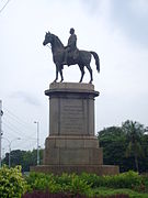
 Equestrian Statue on the Nungambakkam side of Anna (Gemini) fly over.
 -
 Near Willingdon Bridge, seen fromChennai MRTS
 -
 Panagal Maaligai or Panagal Building, Saidapet


.jpg)


.jpg)


See also
References
- ^ a b "Mount Road's takeover tycoons". The Times of India. Chennai. 28 August 2011. Retrieved 31 January 2012.
- ^ "Time travel on Anna Salai". The Hindu. Chennai: Kasturi & Sons. 23 October 2018. pp. 4 (MetroPlus).
- ^ "Anna Salai flyovers proposal shelved". Archived from the original on 26 October 2012. Retrieved 7 August 2011.
- ^ "Chennai's Anna Salai: Frozen in time". The New Indian Express. Chennai: Express Publications. 2 July 2018. Retrieved 23 October 2018.
- ^ "Structure of Chennai" (PDF). Chapter 1. CMDA. Archived from the original (PDF) on 26 August 2013. Retrieved 24 February 2013.
- ^ a b Narayanan, Ayush (2 July 2019). "The Mount Road that was". The Hindu. Chennai: Kasturi & Sons. pp. 5 (MetroPlus). Retrieved 21 July 2019.
- ^ Ramakrishnan, Deepa H. (1 July 2012). "Flyover wall mended after 3 days". The Hindu. Chennai. Retrieved 5 July 2012.
- ^ "Chennai: Bid to ease Anna Salai rush, give push for public transport". The New Indian Express. Chennai: IBN Live. 11 June 2012. Archived from the original on 26 January 2013. Retrieved 20 June 2012.
- ^ Karthikeyan Hemalatha (11 July 2011). "100-Ft Rd, Anna Salai are city's most dangerous". The Times of India. Archived from the original on 26 September 2012. Retrieved 17 January 2013.