
Antler Peak (Washington)
| Antler Peak | |
|---|---|
 Antler Peak seen from the west | |
| Highest point | |
| Elevation | 7,017 ft (2,139 m)[1] |
| Prominence | 377 ft (115 m)[1] |
| Parent peak | Mount Fremont[2] |
| Isolation | 1.97 mi (3.17 km)[2] |
| Coordinates | 46°55′12″N 121°37′56″W / 46.920098°N 121.632278°W[1] |
| Geography | |
 Antler Peak Location of Antler Peak in Washington  Antler Peak Antler Peak (the United States) | |
| Country | United States |
| State | class 2 |
Antler PeakWhite River.
Climate
Antler Peak is located in the
Cascade Mountains. As fronts approach, they are forced upward by the peaks of the Cascade Range (Orographic lift), causing them to drop their moisture in the form of rain or snow onto the Cascades. As a result, the west side of the Cascades experiences high precipitation, especially during the winter months in the form of snowfall. Because of maritime influence, snow tends to be wet and heavy, resulting in high avalanche danger. During winter months, weather is usually cloudy, but due to high pressure systems over the Pacific Ocean that intensify during summer months, there is often little or no cloud cover during the summer.[4]
See also
Gallery
-
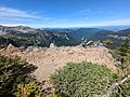 Summit of Antler Peak
 -
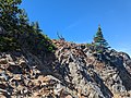 East approach to Antler Peak, just below the summit
 -
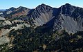 Antler Peak (centered) seen from McNeeley Peak


References
- ^ a b c d "Antler Peak, Washington". Peakbagger.com.
- ^ a b "Antler Peak - 7,017' WA". listsofjohn.com. Retrieved 2024-04-10.
- ^ "Antler Peak". Geographic Names Information System. United States Geological Survey, United States Department of the Interior. Retrieved 2018-08-08.
- ^ a b Beckey, Fred W. Cascade Alpine Guide, Climbing and High Routes. Seattle, WA: Mountaineers Books, 2008.
External links
- National Park Service web site: Mount Rainier National Park
- Weather forecast: Antler Peak