
Ardsley, Pennsylvania
Ardsley, Pennsylvania | ||
|---|---|---|
ZIP codes 19038 | ||
| GNIS feature ID | 1192082[1] | |
Ardsley is an
Ardsley SEPTA station
.
On December 7, 1777, the
Joseph Reed. Farther to the northeast on Edge Hill, riflemen and Maryland militia commanded by Daniel Morgan put up a tougher fight before falling back to join the main army at Camp Hill and Fort Washington.[2]
In 2001, the area was heavily damaged by Tropical Storm Allison. A township project was undertaken to stop future flooding.[3] This project included the re-creation of a drainage basin known locally as "Floaties Pond", which has worked well in that not much more flooding has occurred.
Places of interest
- Ardsley Park
- Ardsley Community Center
- Ardsley SEPTA station
- Ardsley Cemetery
- Ardsley Wildlife Sanctuary (previously "The Dark Woods")
- Joe's Meat Market
Gallery
-
 Ardsley Community Center.
 -
 Ardsley Park.
 -
 Joe's Meat Market.
 -
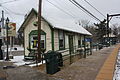 Ardsley SEPTA station.


Notes
- ^ "Ardsley, Pennsylvania". Geographic Names Information System. United States Geological Survey, United States Department of the Interior.
- ^ McGuire, 245-253
- ^ "Specter and Santorum Announce Federal Funding for Hazard Mitigation in Abington". Senator Arlen Specter. May 25, 2004. Archived from the original on March 20, 2010.
References
- McGuire, Thomas J. (2007). The Philadelphia Campaign, Volume II. Mechanicsburg, Penn.: Stackpole Books. ISBN 0-8117-0206-5.
External links
- Ardsley on the Abington Township website.
- School District of Abington Township Website
- Southeastern Pennsylvania Transportation Authority Official Website
Wikimedia Commons has media related to Ardsley, Pennsylvania.

| International | |
|---|---|
| National | |