
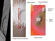
Arsia Mons
 | |
| Feature type | Shield volcano |
|---|---|
| Coordinates | 8°21′S 120°05′W / 8.35°S 120.09°W |
| Peak | 11.7 km (7.3 mi) 38,386 ft (11,700 m) |
| Eponym | Latin – Arsia Silva – classical albedo feature name |
Arsia Mons
Structure
Arsia Mons is a shield volcano with a relatively low slope and a massive caldera at its summit. The southernmost of the three Tharsis Montes volcanoes, it is the only major Tharsis volcano south of the equator.[2]

The volcano is 435 kilometres (270 mi) in diameter, almost 20 kilometres (12 mi) high (more than 9 kilometers (5.6 mi) higher than the surrounding plains[3]), and the summit caldera is 110 km (72 miles) wide.[4] It experiences atmospheric pressure lower than 107 pascals[5] at the summit. Excluding Olympus Mons, it is the largest known volcano in terms of volume. Arsia Mons has 30 times the volume of Mauna Loa in Hawaii, the largest volcano on the Earth.[6]
The caldera of Arsia Mons was formed when the mountain collapsed in on itself after its reservoir of magma was exhausted. There are many other geologic collapse features on the mountain's flanks.[7] The caldera floor formed around 150 Mya ago.[8]
The shield is transected roughly northeast to southwest by a set of collapse features.[9] The collapse features on the shield are connected by a line of small shield volcanoes on the floor of the caldera. It is possible that this line represents a significant fault similar to others found on the Tharsis bulge. This fault may represent the source of the Arsia lavas.
The rift area to the southwest has been imaged in significant detail by the European Space Agency probe Mars Express. In 2004, a 3D map of this region was created at high resolution.[10] Cliffs, landslides, and numerous collapse features can be seen in this detailed image. Combined with the extensive lava flows at the termination of the rift, this may reveal areas that drained the caldera lavas and contributed to the collapse.
The northwest flank of the volcano is significantly different and rougher than the southeast flank, and the features may represent evidence of glaciers.[11]
Possible plate tectonics

The three Tharsis Montes, together with some smaller volcanoes to the north, form a rather straight line. It has been proposed that these are the result of plate tectonics, which on Earth makes chains of "hot spot" volcanoes.[12][13][14]
History
The most recent eruptive episode in the history of Arsia Mons, among the youngest on Mars, involved at least 29 vents within the caldera and also eruptions on the flank aprons along the north-south axis of the volcano. This activity is thought to have extended from 200–300 Ma to 10–90 Ma ago, peaking at 150 Ma with eruption rates in the caldera of 1–8 km3 per Ma.[15] This low recent rate contrasts with an average rate of 270 km3/Ma over the volcano's inferred entire 3400 Ma history.[16]
Weather
A repeated weather phenomenon occurs each year near the start of southern winter over Arsia Mons. Just before southern winter begins, sunlight warms the air on the slopes of the volcano. On the leeward slope, water ice condenses, forming a cloud which can extend westward for more than 1000 km. The autumn of 2018 saw a particularly pronounced version of this orographic cloud, as the planet-wide dust storm finally subsided. The presence of some dust undoubtedly emphasised the phenomenon. This phenomenon has been repeatedly observed by the Mars Express orbiter.[17][18]
A study using a global climate model found that the Medusae Fossae Formation could have been formed from ancient volcanic ash from Apollinaris Mons, Arsia Mons, and possibly Pavonis Mons.[19]
Glaciers
Recent work provides evidence for glaciers on Arsia Mons at both high
Possible cave entrances
As of 2007 seven putative cave entrances, have been identified in satellite imagery of the flanks of Arsia Mons.[22][23][24] They have been informally dubbed Dena, Chloë, Wendy, Annie, Abbey, Nikki, and Jeanne and resemble "skylights" formed by the collapse of lava tube ceilings.


- Dena (6°05′02″S 239°03′40″E / 6.084°S 239.061°E)
- Chloë (4°17′46″S 239°11′35″E / 4.296°S 239.193°E)
- Wendy (8°05′56″S 240°14′31″E / 8.099°S 240.242°E)
- Annie (6°16′01″S 240°00′18″E / 6.267°S 240.005°E)
- Abbey and Nikki (8°29′53″S 240°20′56″E / 8.498°S 240.349°E)
- Jeanne (5°38′10″S 241°15′32″E / 5.636°S 241.259°E)
From day to night, temperatures of the circular features change only about one-third as much as the change in temperature of surrounding ground. While this is more variable than large caves on Earth, it is consistent with there being deep pits. However, due to the extreme altitude, it is unlikely that they will be able to harbour any form of Martian life.[25]
A more recent photograph of one of the features shows sunlight illuminating a side wall, suggesting that it may simply be a vertical pit rather than an entrance to a larger underground space.[26] Nonetheless, the darkness of this feature implies that it must be at least 178 meters deep.[27]
Gallery
-
 Arsia Mons, as seen by THEMIS. Click on image to see relationship of Arsia Mons to other nearby volcanoes.
 -
 Arsia Mons and its surroundings in a THEMIS daytime infrared image mosaic. A huge fan-shaped expanse of knobby deposits (the Arsia Sulci), believed left by past glaciation, extends northwestward from the mountain.
 -
 Layers from numerous lava flows are exposed on the side of a pit on the lower west flank of Arsia Mons (photo by HiRISE).
 -
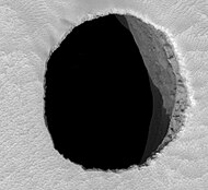 Possible cave entrance ("Jeanne") on Arsia Mons


See also
- Caves of Mars Project
- List of mountains on Mars by height
- List of tallest mountains in the Solar System
- Tharsis quadrangle
References
- OCLC 3650136.
- ]
- ^ Catalog Page for PIA02337
- ^ Catalog Page for PIA03948
- ^ Martian Weather Observation Archived March 11, 2007, at the Wayback Machine NASA MGS data 9.2 degrees S 238.2 degrees E 17757 meters 1.07 mbar
- ISBN 978-0-521-85226-5.
- ^ Catalog Page for PIA03799
- ]
- ]
- ESA. Retrieved 2012-04-01.
- ^ a b Head, James; et al. "Cold-based mountain glaciers on Mars: Western Arsia Mon" (PDF). Geological Society of America. Archived from the original (PDF) on 2020-01-14. Retrieved 2012-04-01.
- .
- ^ "Mars Once Had Bizarre 'Shell' Tectonics". Archived from the original on 2011-06-03. Retrieved 2010-12-16.
- PMID 16217034.
- .
- PMID 28974682.
- NASASpaceFlight. Retrieved 23 April 2021.
- ESA. 25 October 2018. Retrieved 23 April 2021.
- .
- doi:10.1029/2006JE002761. Archived from the original(PDF) on 24 September 2015. Retrieved 1 April 2012.
- ^ Scanlon,K., J. Head, D. Marchant. 2015. REMNANT BURIED ICE IN THE ARSIA MONS FAN-SHAPED DEPOSIT, MARS. 46th Lunar and Planetary Science Conference. 2266.pdf
- ^ Themis Observes Possible Cave Skylights on Mars. G. E. Cushing, T. N. Titus, J. J. Wynne, P. R. Christensen. Lunar and Planetary Science XXXVIII (2007)
- ^ Lakdawalla, Emily (2007-05-23). "Windows onto the abyss: cave skylights on Mars". The Planetary Society Weblog. Archived from the original on 26 May 2007. Retrieved 2007-05-26.
- ^ Lakdawalla, Emily (2007-08-30). "The cave entrance on Arsia Mons really is a pit". The Planetary Society Weblog. Archived from the original on 2012-04-01. Retrieved 2011-02-27.
- ^ "NASA Orbiter Finds Possible Cave Skylights on Mars". Jet Propulsion Laboratory. Archived from the original on 27 September 2007. Retrieved 2007-09-22.
- ^ Shiga, David (2007-08-30). "Strange Martian feature not a 'bottomless' cave after all". NewScientist.com news service.
- ^ "New View of Dark Pit on Arsia Mons". University of Arizona. 5 September 2007.
External links
- A Hole in Mars – Astronomy Picture of the Day for 28 May 2007
- "Arsia Mons". Gazetteer of Planetary Nomenclature. USGS Astrogeology Research Program.
- The Cave in Arsia Mons is a science fiction story by astronomer Andrew Fraknoi, published in the anthology Building Red