
Arzakan
40°26′58″N 44°36′23″E / 40.44944°N 44.60639°E
Arzakan
Արզական | |
|---|---|
Village | |
 Arzakan | |
 Arzakan | |
| Coordinates: 40°26′58″N 44°36′23″E / 40.44944°N 44.60639°E | |
| Country | Armenia |
| Province | Kotayk |
| Population (2008) | |
| • Total | 2,889 |
Arzakan (
Neghutsi Vank
, located along a ravine to the northwest of the village. There are also the 13th-century monastic ruins of Ghuki Vank and 13th-century ruins of Surb Gevorg in the vicinity.
Gallery
-
 S. Astvatsatsin Church at Neghutsi Vank, 10th-11th centuries
 -
 South entrance to the gavit at Neghutsi Vank
 -
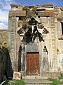
 Village church door
 -
 Stone pillar set on a plinth with a carving of a woman (possibly S. Astvatsatsin) adjacent to the church
 -
 S. Astvatsatsin Church, 1207
 -
 Ghuki Vank, 13th century


.jpg)
See also
References
- Arzakan at GEOnet Names Server
- World Gazeteer: Armenia[dead link] – World-Gazetteer.com
- Report of the results of the 2001 Armenian Census, Statistical Committee of Armenia
Wikimedia Commons has media related to Arzakan.
Capital: Hrazdan | |||
| Urban settlements | Abovyan Municipality | ||
Akunk Municipality | |||
Arzni Municipality | |||
Byureghavan Municipality | |||
Charentsavan Municipality | |||
Garni Municipality | |||
Hrazdan Municipality | |||
Jrvezh Municipality | |||
Nairi Municipality | |||
Nor Hachn Municipality | |||
Tsaghkadzor Municipality | |||
This article about a location in Kotayk Province, Armenia is a stub. You can help Wikipedia by expanding it. |