
Ptghni
Ptghni Պտղնի | |
|---|---|
UTC+5 |
Ptghni (
Gallery
-
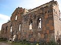 Ptghnavank, 6th-7th c.
 -
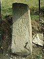 Khachkar monument beside the road leading to the village.


See also
References
- ^ "Ptghni (Kotayk)". CAA: Union of Communities of Armenia. Archived from the original on July 6, 2011. Retrieved June 2, 2015.
- ISBN 99941-0-121-8.
- Ptghni at GEOnet Names Server
- World Gazeteer: Armenia[dead link] – World-Gazetteer.com
- Report of the results of the 2001 Armenian Census, Statistical Committee of Armenia
- Ptghnavank Monastery
- Ptghnavank2
- Ptghnavank3
- Ptghnavank4
- Ptghnavank5
External links
- Communities Association of Armenia: Ptghni
- Ptghnavank MonasteryPtghnavank2Ptghnavank3Ptghnavank4Ptghnavank5
Capital: Hrazdan | |||
| Urban settlements | Abovyan Municipality | ||
Akunk Municipality | |||
Arzni Municipality | |||
Byureghavan Municipality | |||
Charentsavan Municipality | |||
Garni Municipality | |||
Hrazdan Municipality | |||
Jrvezh Municipality | |||
Nairi Municipality | |||
Nor Hachn Municipality | |||
Tsaghkadzor Municipality | |||
This article about a location in Kotayk Province, Armenia is a stub. You can help Wikipedia by expanding it. |