
Zoravan
Zoravan Զորավան | |
|---|---|
UTC+4 |
Zoravan (
Grigor Mamikonian. The community currently has a school and a kindergarten. Drinking water for the village comes from a source near Karenis, while water for irrigation comes from Lake Sevan.[1][2]
Gallery
-
 Gharghavank in relation to the villages of Zoravan (left) and Yeghvard (right)
 -
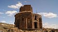 Gharghavank, 7th c.
 -
 Funeral chapel adjacent to the church


See also
References
- ^ "Zoravan (Kotayk)". CAA: Union of Communities of Armenia. Retrieved May 30, 2015.
- ISBN 99941-0-121-8.
- Zoravan at GEOnet Names Server
- World Gazeteer: Armenia[dead link] – World-Gazetteer.com
- Report of the results of the 2001 Armenian Census, Statistical Committee of Armenia
Capital: Hrazdan | |||
| Urban settlements | Abovyan Municipality | ||
Akunk Municipality | |||
Arzni Municipality | |||
Byureghavan Municipality | |||
Charentsavan Municipality | |||
Garni Municipality | |||
Hrazdan Municipality | |||
Jrvezh Municipality | |||
Nairi Municipality | |||
Nor Hachn Municipality | |||
Tsaghkadzor Municipality | |||
This article about a location in Kotayk Province, Armenia is a stub. You can help Wikipedia by expanding it. |