
Arzberg, Saxony
Arzberg | ||
|---|---|---|
Location of Arzberg within Nordsachsen district  | ||
Municipal assoc. Beilrode | | |
| Government | ||
| • Mayor (2023–30) | Holger Reinboth[1] | |
| Area | ||
| • Total | 58.23 km2 (22.48 sq mi) | |
| Elevation | 84 m (276 ft) | |
| Population (2022-12-31)[2] | ||
| • Total | 1,848 | |
| • Density | 32/km2 (82/sq mi) | |
| Time zone | UTC+01:00 (CET) | |
| • Summer (DST) | UTC+02:00 (CEST) | |
| Postal codes | 04886 | |
| Dialling codes | 034222 | |
| Vehicle registration | TDO, DZ, EB, OZ, TG, TO | |
| Website | www.gemeinde-arzberg.de | |
Arzberg (German: [ˈaʁtsbɛʁk] ⓘ) is a municipality in the district Nordsachsen, in Saxony, Germany.
History
From 1815 to 1944, Arzberg was part of the Prussian Province of Saxony, from 1944 to 1945 of the Province of Halle-Merseburg, from 1945 to 1952 of the State of Saxony-Anhalt, from 1952 to 1990 of the Bezirk Leipzig of East Germany and since 1990 of Saxony.
Gallery
-
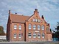 Old school building, now museum of local history
 -
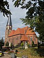 Arzberg church
 -
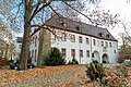
 Pülswerda castle
 -
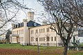
 Triestewitz castle


References
Wikimedia Commons has media related to Arzberg (Sachsen).
- Statistisches Landesamt des Freistaates Sachsen. Retrieved 6 July 2023.
- Statistisches Landesamt des Freistaates Sachsen. 2024.
Towns and municipalities in Nordsachsen district | ||
|---|---|---|
| International | |
|---|---|
| National | |
This Nordsachsen location article is a stub. You can help Wikipedia by expanding it. |