
Baborów
Baborów | |
|---|---|
Town | |
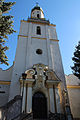
 Saint Joseph Church | |
|
UTC+2 (CEST) | |
| Postal code[5] | 48-120 |
| Area code[6] | +48 77 |
| Number plates[7] | OGL |
| Website | http://www.baborow.pl |
Baborów [baˈbɔruf] (German: Bauerwitz) is a town in Gmina Baborów, Głubczyce County, Opole Voivodeship, southern Poland. The town has an area of 11.86 square kilometres (4.58 square miles),[2] and as of June 2022 it has a population of 2,852.[3] Baborów lies on the river Psina.
History
The first mention of the town comes from 1296 in which a
According to the German census of 1890, the town had a population of 2,707, of which 2,220 (82%) were Czechs.[10] It marked the 19th-century linguistic border between German, Polish, and Czech.[11]
During World War II, the town, then known as Bauerwitz, was the base for two working parties (E288 and E398) of British and Commonwealth prisoners of war, under the administration of the German Stalag VIII-B/344 POW camp at Łambinowice (then known as Lamsdorf).[12] In January 1945, as the Soviet armies resumed their offensive and advanced from the east, the prisoners were marched by the Germans westward in the so-called Long March or Death March. Many of them died from the bitter cold and exhaustion. The lucky ones got far enough to the west to be liberated by the allied armies after some four months of travelling on foot in appalling conditions.[13] The town's German population was interned in Łambinowice camp, and expelled.[citation needed]
Notable people
- Kazimierz Szczygielski (1946–2019), Polish geographer and politician, member of the Polish Sejm.
International relations
Twin towns – sister cities
See twin towns of Gmina Baborów.
Gallery
-
 St. Mary column
 -
 World War II memorial
 -
 Assumption of Mary Church
 -
 Sacred Heart Chapel


References
- ^ "Kierownictwo Urzędu". www.baborow.pl (in Polish). Gmina Baborów. Retrieved 22 August 2022.
- ^ a b "Local Data Bank". bdl.stat.gov.pl. Statistics Poland. Retrieved 16 March 2023. Category K1, group G441, subgroup P1410. Data for territorial unit 1602014.
- ^ a b "Local Data Bank". bdl.stat.gov.pl. Statistics Poland. Retrieved 16 March 2023. Category K3, group G7, subgroup P1336. Data for territorial unit 1602014.
- ^ "Local Data Bank". bdl.stat.gov.pl. Statistics Poland. Retrieved 16 March 2023. Category K3, group G7, subgroup P2425. Data for territorial unit 1602014.
- Poczta Polska. pp. 9, 1655. Retrieved 16 March 2023.
- ^ Rozporządzenie Ministra Administracji i Cyfryzacji z dnia 30 października 2013 r. w sprawie planu numeracji krajowej dla publicznych sieci telekomunikacyjnych, w których świadczone są publicznie dostępne usługi telefoniczne, Dz. U. z 2013 r. poz. 1281 (2013-10-30)
- ^ Rozporządzenie Ministra Infrastruktury z dnia 31 sierpnia 2022 r. w sprawie rejestracji i oznaczania pojazdów, wymagań dla tablic rejestracyjnych oraz wzorów innych dokumentów związanych z rejestracją pojazdów, Dz. U. z 2022 r. poz. 1847 (2022-08-31)
- ISBN 9788322616161.
- ^ "Historia Powiatu Prudnickiego". powiatprudnicki.pl (in Polish). Prudnik County. Retrieved 16 March 2023.
- ^ "Deutsche Verwaltungsgeschichte Schlesien, Kreis Leobschuetz". treemagic.org (in German). Archived from the original on 28 July 2019. Retrieved 19 January 2021.
- ^ Weinhold, Karl (1887). Die Verbreitung und die Herkunft der Deutschen in Schlesien [The Spread and the Origin of Germans in Silesia] (in German). Stuttgart: J. Engelhorn. p. 194.
- ^ "Working Parties". Stalag VIIIB 344 Lamsdorf. Archived from the original on 29 October 2020. Retrieved 16 March 2023.
- ^ "History". Stalag VIIIB 344 Lamsdorf. Archived from the original on 25 November 2020. Retrieved 16 March 2023.
External links
- Official website (in Polish)
| Town and seat |  | |
|---|---|---|
| Villages | ||
| International | |
|---|---|
| National | |