
Bad Lippspringe
Bad Lippspringe | |
|---|---|
 Town hall of Bad Lippspringe | |
 Coat of arms | |
Location of Bad Lippspringe within Paderborn district  | |
 Bad Lippspringe  Bad Lippspringe | |
| Coordinates: 51°47′00″N 8°49′00″E / 51.78333°N 8.81667°E | |
| Country | Germany |
| State | North Rhine-Westphalia |
| Admin. region | Detmold |
| District | Paderborn |
| Government | |
| • Mayor (2020–25) | Ulrich Lange[1] (CDU) |
| Area | |
| • Total | 50.99 km2 (19.69 sq mi) |
| Elevation | 140 m (460 ft) |
| Population (2022-12-31)[2] | |
| • Total | 16,808 |
| • Density | 330/km2 (850/sq mi) |
| Time zone | UTC+01:00 (CET) |
| • Summer (DST) | UTC+02:00 (CEST) |
| Postal codes | 33175 |
| Dialling codes | 05252 |
| Vehicle registration | PB |
| Website | www.bad-lippspringe.de |
Bad Lippspringe (German: [baːt lɪpˈʃpʁɪŋə] ⓘ) is a town in the district of Paderborn, in North Rhine-Westphalia, Germany.
Geography
Bad Lippspringe is situated on the western slope of the Teutoburger Wald,
Climate
| Climate data for Bad Lippspringe (1991–2020 normals) | |||||||||||||
|---|---|---|---|---|---|---|---|---|---|---|---|---|---|
| Month | Jan | Feb | Mar | Apr | May | Jun | Jul | Aug | Sep | Oct | Nov | Dec | Year |
| Mean daily maximum °C (°F) | 4.6 (40.3) |
5.5 (41.9) |
9.4 (48.9) |
14.3 (57.7) |
18.2 (64.8) |
21.3 (70.3) |
23.6 (74.5) |
23.3 (73.9) |
19.0 (66.2) |
13.9 (57.0) |
8.7 (47.7) |
5.4 (41.7) |
13.9 (57.0) |
| Daily mean °C (°F) | 2.1 (35.8) |
2.5 (36.5) |
5.4 (41.7) |
9.4 (48.9) |
13.2 (55.8) |
16.2 (61.2) |
18.2 (64.8) |
18.1 (64.6) |
14.3 (57.7) |
10.2 (50.4) |
6.0 (42.8) |
3.0 (37.4) |
9.9 (49.8) |
| Mean daily minimum °C (°F) | −0.6 (30.9) |
−0.6 (30.9) |
1.5 (34.7) |
4.2 (39.6) |
7.8 (46.0) |
10.7 (51.3) |
13.1 (55.6) |
13.1 (55.6) |
10.0 (50.0) |
6.7 (44.1) |
3.3 (37.9) |
0.5 (32.9) |
5.8 (42.4) |
| Average precipitation mm (inches) | 87.6 (3.45) |
64.0 (2.52) |
64.8 (2.55) |
53.0 (2.09) |
64.4 (2.54) |
70.8 (2.79) |
90.2 (3.55) |
85.7 (3.37) |
77.0 (3.03) |
76.6 (3.02) |
79.6 (3.13) |
88.6 (3.49) |
902.5 (35.53) |
| Average precipitation days (≥ 1.0 mm) | 19.0 | 16.8 | 16.5 | 13.6 | 14.7 | 15.5 | 15.9 | 15.7 | 15.1 | 16.8 | 18.3 | 20.4 | 198.4 |
| Average snowy days (≥ 1.0 cm) | 6.0 | 6.7 | 2.0 | 0.1 | 0 | 0 | 0 | 0 | 0 | 0 | 1.1 | 4.2 | 20.1 |
| Average relative humidity (%)
|
83.9 | 81.2 | 76.6 | 70.2 | 70.7 | 72.1 | 71.7 | 72.3 | 78.0 | 81.9 | 85.1 | 85.5 | 77.4 |
| Mean monthly sunshine hours | 52.3 | 69.4 | 117.4 | 166.5 | 192.5 | 191.5 | 198.2 | 187.4 | 141.3 | 102.6 | 51.3 | 41.6 | 1,512.7 |
| Source: World Meteorological Organization[5] | |||||||||||||
History
Lippspringe is mentioned in chronicles as early as the 9th century, and here in the 13th century the order of the Templars established a stronghold. It received civic rights about 1400.[3] Friedrich Wilhelm Weber was born here in 1817. During the 19th century, the Arminius spring and the Liborius spring, with saline waters of a temperature of 21 °C (70 °F), were used both for bathing and drinking in cases of tuberculosis.[3]
Sports
The local football team is BV Bad Lippspringe, which Antonio Di Salvo started his career with, after being born nearby.
Bad Lippspringe is home to RAPA (Rhine Army Parachute Association), a British Army Parachute and Skydiving Dropzone. This was formed in 1964 and is still going today.
People born in Bad Lippspringe born or connected to the city
- Friedrich Wilhelm Weber (1813–1894), German epic poet, fountain doctor in Lippspringe
- Alexander Hermann, Count of Wartensleben (1650–1734), Prussian field marshal
- Friedrich Kühn (1907–1979), German politician of the CDU, who was born in Bad Lippspringe
- Wilhelm Wegener (1911–2004), legal historian and genealogist
- Erich Fuchs (1921–2008), German internist and allergist, many years top and chief physician at the Asthma Clinic Allergy Research Institute in Bad Lippspringe
- Sabine Lösing (born 1955), member of the European Parliament, grew up in Bad Lippspringe
- Markus Gellhaus (born 1970), German football coach, played football at BV Bad Lippspringe
- Antonio Di Salvo (born 1979), Italian footballer, played football at BV Bad Lippspringe
Gallery
-
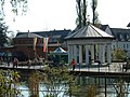 Arminiusquelle with Lippequelle in the foreground
 -

-
 25-Pfennig Notgeld from 1921


References
- ^ Wahlergebnisse in NRW Kommunalwahlen 2020, Land Nordrhein-Westfalen, accessed 29 June 2021.
- Landesbetrieb Information und Technik NRW. Retrieved 20 June 2023.
- ^ a b c One or more of the preceding sentences incorporates text from a publication now in the public domain: Chisholm, Hugh, ed. (1911). "Lippspringe". Encyclopædia Britannica. Vol. 16 (11th ed.). Cambridge University Press. pp. 742–743. Further citations:
- Dammann, Der Kurort Lippspringe (Paderborn, 1900);
- Koniger, Lippspringe (Berlin, 1893); and
- Frey, Lippspringe, Kurort für Lungenkranke (Paderborn, 1899).
- ^ "The Spring of the River Lippe". Paderborner Land. Touristikzentrale Paderborner Land e. V. Retrieved 25 September 2015.
- ^ "World Meteorological Organization Climate Normals for 1991–2020". World Meteorological Organization Climatological Standard Normals (1991–2020). National Oceanic and Atmospheric Administration. Archived from the original on 12 October 2023. Retrieved 12 October 2023.
External links
- Official site (in German)
- Bad Lippspringe Notgeld (Emergency banknotes from the town of Lippspringe) http://webgerman.com/Notgeld/Directory/L/Lippspringe1.htm One note shows the baptism of the Saxons in 776 after submitting to Charlemagne (Die Sachsentaufe).
Towns and municipalities in Paderborn (district) | ||
|---|---|---|
 | ||
| International | |
|---|---|
| National | |
| Geographic | |