
Bahía de Ponce
| Bahía de Ponce | |
|---|---|
| Ponce Bay | |
Barrio Playa, Ponce | |
| 1 Shore length is not a well-defined measure. |
.png)
Bahía de Ponce (Ponce Bay) is a
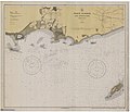
Bahía de Ponce is located in southern Puerto Rico, about midway on the southern coast. It has a width of 3.5 mi (5.6 km), a length of 1.5 miles, its shore is about 4.0 mi (6.4 km) and its area is approximately 3,300 acres (13 km2). Typical bay depths are in the 20 ft (6.1 m)-to-40 ft (12 m) range, but these dip to 50 feet (15 m) at the drenched piers.
The Bay provides recreation, sightseeing and tourist attractions. It also provides for commercial and industrial activities. The Rafael Cordero Santiago Port of the Americas is located here as well as the La Guancha Recreational and Cultural Complex, the La Guancha Boardwalk, and Club Náutico de Ponce. The annual Cruce a Nado Internacional swimming sports event is held at this Bay every September.
History
The history of the Bahía de Ponce is closely tied to the history of
During the 1600s and 1700s, significant contraband took place near Ponce shores as well as attempts to attack, ransack, and invade the Playa settlement. A lookout post was set up in the
But threat from sea upon the Puerto Rican shore settlement continued. In both August 1800 and October 1801, for example, a fleet of
The waters off Bahía de Ponce saw significant amounts of piracy during this period as well. In 1825, the last major pirate in the Caribbean, Roberto Cofresí, was apprehended after two armed Spanish sloops docked at Bahía de Ponce and the American schooner Grampus hunted down pirate.[12]
By the 1830s, La Playa had one of the best roads in Puerto Rico (today's
In 1845, however, La Playa experienced a major fire that destroyed Barrio Playa and most of the Ponce vicinity.
In 1887 the Spanish government built the Caja de Muertos Light on an island by the same name just off the coast of barrio Playa.[18] This was followed by the building of Cardona Island Light lighthouse in 1889, on a small island called Isla Cardona located at the entrance of Bahía de Ponce.[19] Both of these islands are part of barrio Playa.[20][21][22]
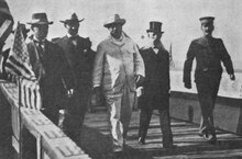
In 1898, Bahía de Ponce was the entry point of the invading forces of the United States on 27 July.[23] Relative to the other ports on the Island at the time, the Port of Ponce had better facilities and its harbor could accommodate large ships.[note 1] It was also used by U.S. president Theodore Roosevelt on 21 November 1906 in his visit to the island. The American forces in Puerto Rico built a new pier at Avenida Hostos Final for his visit, though this pier no longer exists.[24] In a speech to Congress three weeks later President Roosevelt explained "I could not [dis]embark at San Juan because the harbor has not been dredged out and cannot receive an American battleship."[25]
By 1913, Playa was "a dynamic neighborhood with a self-sustained urban development with a population of 5,169 distributed through a residential area dominated by wooden houses, sugar cane farms, churches, schools, hospitals, a cemetery and local industries that promoted the formation of a strong artisan and industrial workers class."[26] Playa has been called "Puerto Rico's first planned suburban area".[27]
In 2009, Barrio Playa was a mostly working class barrio of Ponce,[28] with a modern shopping mall, a 4-star hotel, several parks, and numerous sports and recreational facilities, among others, and its bay is home to the most important commercial harbor on the Puerto Rico's Caribbean coast and the second largest in the island.[29][30]
Topography
.jpg)
The Bay is bounded in the west by
The land masses at Punta Peñoncillo and Isla de Gatas protect the bay from the prevailing east winds, but the bay is exposed to the Caribbean Sea on the South.
The building of the Port of the Americas will claim 70 acres of bay space for land use.[38]
Hydrography
,_Ponce,_PR_(DSC05629).jpg)
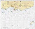
The continental shelf at Bahía de Ponce is over 5 miles wide, after which it dips steeply into the Venezuelan Basin. Maritime obstructions for vessels entering the Bay include seven features: Bajo Tasmanian, Bajo Cardona, Roca Ahogado, Las Hojitas, Cayo Viejo,
Oceanography
.jpg)
Bahía de Ponce is located between Cabo Rojo Light in Cabo Rojo (32 miles west of Bahía de Ponce) and Punta Tuna Light in Maunabo (43 miles to the east). The bay has a width of 3.5 mi (5.6 km),[40][b] a length of 1.5 miles,[41] its shore is about 4.0 mi (6.4 km) and its area is approximately 3,300 acres (13 km2).[42] Typical bay depths are in the 20 ft (6.1 m)-to-40 ft (12 m) range, but these dip to 50 feet (15 m) at the drenched piers.[43]
Wind patterns at Bahía de Ponce are generally from the east, with a southeast onshore component. Average east-southeast knots of 7.7 miles per hour exists year-around, with March being the windiest month.[44] The bay receives an average of 32 inches of rain per year.[45] The average tidal wave is about 1.1 feet high.[46] Water surface currents have a net flow of 12–40 cm/sec to the Northeast, and the prevailing flow of surface waters is shoreward in a Northwest direction.[47]
In 1971, untreated domestic sewage entered the bay through an outfall off
The primary treated submarine sewage outfall to Bahia de Ponce was relocated to discharge at a depth of 150 m down the insular slope below the pycnocline. The Ponce ocean outfall is 150 meters deep, "all other outfalls discharge within the insular shelf at depths ranging between 15–40 m on the north coast of Puerto Rico."[52]
Bay wildlife


Birds on the bay include the
These are also at the Punta Cucharas western end of the bay: Puerto Rican oriole (Icterus portoricensis), brown pelican (Pelecanus occidentalis), peregrine falcon (Falco peregrinus), Puerto Rican vireo (Vireo latimeri), and white-cheeked pintail (Anas bahamensis).[60]
Marine life at the bay includes:
Maritime services
The
Government services on the Bay include the
The usual anchorage is northeast of Isla de Cardona in depths of 30 to 50 feet, but vessels can also anchor in 30 to 40 feet depths northwest of Las Hojitas. A small-craft anchorage is located northeast of Las Hojitas in depths of 18 to 28 feet. A well-protected anchorage for small boats in depths of 19 to 30 feet is northeast of the
Industrial activities
In addition to the industrial support offered by maritime traffic entering and exiting the Port of Ponce, several industries have settled on or in the vicinity of the Bay.[71] During the 1970s, the Ralston-Purina Tuna Fish Packing Plant operated on the Bay, but has since shut down its operations.[72]
Recreational activities

The bay supports commercial enterprises including recreational fishing.
The annual
Gallery
Marine life
-
 Antillean manatee(Trichechus manatus)
 -
 Red hind (Epinephelus guttatus)
 -
 Nassau grouper (Epinephelus striatus)
 -
 Mutton snapper (Lutjanus analis)
 -
 Schoolmaster snapper (Lutjanus apodus)
 -
 Gray snapper(Lutjanus griseus)
 -
 Yellowtail snapper (Ocyurus chrysurus)
 -
 White grunt(Haemulon plumierii)
 -
 Banded butterflyfish (Chaetodon striatus)
 -
 Queen triggerfish(Balistes vetula)
 -
 Redtail parrotfish(Sparisoma chrysopterum)
 -
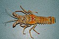 Caribbean spiny lobster(Panulirus argus)
 -
 Queen conch(Strombus gigas)


.jpg)


.jpg)
Marine birds
-
 Roseate tern (Sterna dougallii dougallii)
 -
 White-cheeked pintail (Anas bahamensis)
 -
 Peregrine falcon (Falco peregrinus)
 -
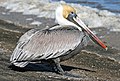 Brown pelican (Pelecanus occidentalis)
 -
 Blue-winged teal (Anas discors)
 -
 Piping plover (Charadrius melodus)
 -
 Western sandpiper (Calidris mauri)


.jpg)

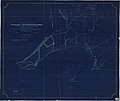
Maps
-
 October 1898 map of Bahía de Ponce
 -
 March 1899 map of Bahía de Ponce
 -
 December 1903 map of Bahía de Ponce
 -
 December 1929 map of Bahía de Ponce
 -
 January 1940 map of Bahía de Ponce
 -
 July 1971 map of Bahía de Ponce
 -
 June 1975 map of Bahía de Ponce
 -
 March 1979 map of Bahía de Ponce
 -
 February 1984 map of Bahía de Ponce
 -
 December 1985 map of Bahía de Ponce
 -
 December 1991 map of Bahía de Ponce
 -
 September 1996 map of Bahía de Ponce
 -
 February 1998 map of Bahía de Ponce
 -
 November 2000 map of Bahía de Ponce
 -
 May 2003 map of Bahía de Ponce
 -
 October 2012 map of Bahía de Ponce
.jpg)
.jpg)
.jpg)
.jpg)
.jpg)
.jpg)
.jpg)
.jpg)
.jpg)
.jpg)
.jpg)
.jpg)
.jpg)
.jpg)
.jpg)
.jpg)
Others
-
 Beach at Bahía de Ponce (Club Náutico)
 -
 Ships at Bahía de Ponce in 1899
.jpg)

See also
Notes
- ^ In 1911 the U.S. Federal Government granted the City of Ponce a perpetual franchise to operate the Port. During the second decade of the 20th century (1910s), a new harbor was built. (See La Vuelta de la Feria: Segunda Parte del Juguete Cómico "Los Jíbaros Progresistas o La Feria de Ponce", Original y en Verso." Ramon Mendez Quiñones. Tipografía "El Vapor". Ponce, Puerto Rico. 28 July 1882. Archivo Digital Nacional de Puerto Rico. p. 244 (footnote). Accessed 5 April 2019.) The new Port of Ponce was built on Punta Peñoncillo, where it currently (2019) stands.
Footnotes
- ^ Surface salinity at surface temperature of 28.4 °C, as measured on 3 June 1971.
- RNPC, is located "some 5 km west of the port facilities", which are about 0.5 km short of the extreme eastern end of the Bahía . ("Determinacion de la Presencia..." was reprinted in Scientific International Journal as "Presencia y Concentracion de metales pesados", Vol 13, No. 2, May–August 2016, pp 17–31)
References
- ^ Ponencia del Gobierno Municipal Autonomo de Ponce Before the Senate of Puerto Rico. Rafael Cordero Santiago, Alcalde de Ponce. Page 5. Accessed 19 September 2018.
- ^ Neysa Rodriguez Deynes. Brevario Sobre la Historia de Ponce. Second Edition. Government of the Autonomous Municipality of Ponce. 2002. Page 14. Printed by Impress Quality Printing, Bayamon, Puerto Rico.
- ^ Administración Municipal engaña a los ponceños indica presidente del PPD en Ponce. El Sur a la Vista. Ponce, Puerto Rico. 12 December 2011. Retrieved 14 December 2011.
- ^ Part Two: The Transportation Planning Regions – Context and Cost-Feasible Plans: South and Southeast. "Puerto Rico's Five Transportation Planning Regions (TPRS): 2040 Long Range Transportation Plans." Puerto Rico Department of Transportation. December 2013. Page 7-43. Accessed 19 September 2018.
- ^ Oceanographic Baseline Data (1971–72) for the Formulation of Marine Waste Disposal Alternatives for Puerto Rico. (Volume II: Appendices. Final Report – November 1974.) November 1974. Prepared For: Environmental Quality Board (Junta de Calidad Ambiental), Office of the Governor, Commonwealth of Puerto Rico. Prepared by: Oceanographic Program, Area of Natural Resources, Department of Public Works, Commonwealth of Puerto Rico. Table G-4, pages 7.147–7.148. Figures G-1 and G-2, pages 7.151–7.152.
- ISBN 978-1547284931
- ^ Un operador busca transformar el Puerto de las Américas de Puerto Rico. The San Diego Union-Tribune. 14 September 2015. Accessed 28 September 2018.
- ^ Historia de Puerto Rico. Paul G. Miller. Chicago and New York: Rand McNally & Compañia. 1992. Page 235.
- ^ Historia de Puerto Rico. Paul G. Miller. Chicago and New York: Rand McNally & Compañia. 1992. Page 186.
- ^ Historia de Puerto Rico. Paul G. Miller. Chicago and New York: Rand McNally & Compañia. 1992. Page 451.
- ^ Ley de la Autoridad del Puerto de Ponce para crear la Autoridad del Puerto de Ponce (Ley 240 del 12 de diciembre de 2011) Archived 29 September 2018 at the Wayback Machine Legislative Assembly of Puerto Rico. 12 December 2011. Page 4. Accessed 28 September 2018.
- ^ Historia de Puerto Rico. Paul G. Miller. Chicago and New York: Rand McNally & Compañia. 1992. Page 253.
- ^ Declaracion de Impacto Ambiental: Estrategia. Centros Urbanos de Ponce. Sectores VII & VIII, La Playa y la Avenida Hostos. (Plan de Area de los Centros Urbanos. PL.E.6 La Playa, PL.E.7 La Avenida Hostos.) Municipio de Ponce. Oficina de Ordenación Territorial. January 2009. Page 21. Accessed 1 October 2018.
- ^ Aida Belen Rivera Ruiz, Certifying Official, and Juan Llanes Santos, Preparer, Puerto Rico Historic Preservation Office. (San Juan, Puerto Rico) 26 February 2008. In National Register of Historic Places Inventory-Nomination Form – McCabe Memorial Church. United States Department of the Interior. National Park Service. (Washington, D.C.) Section 8. Page 15. Listing Reference Number 80000283. Published 11 April 2008.
- ^ Eduardo Neumann. Verdadera y Auténtica Historia de la Ciudad de Ponce. 1913. Reprinted by the Instituto de Cultura Puertorriqueña. 1987. Page 194. (In Spanish)
- ^ James C. Massey, Exec. Vice Pres., and Shirley Maxwell, Associate, National Preservation Institute (National Building Museum) Washington, D.C. and the Federal Historic Preservation Office, U.S. Department of the Treasury. (Washington, D.C.) 7 January 1988. In National Register of Historic Places Registration Form – U.S. Custom House, Ponce. United States Department of the Interior. National Park Service. (Washington, D.C.) Section 8, Page 3. Listing Reference Number 88000073. 10 February 1988.
- ^ Eduardo Neumann. Verdadera y Auténtica Historia de la Ciudad de Ponce. 1913. (In Spanish) Reprinted by the Instituto de Cultura Puertorriqueña. 1987. Page 194. (In Spanish)
- ^ National Register of Historic Places Inventory-Nomination Form – Isla Caja de Muertos Light. United States Department of the Interior. National Park Service. (Washington, D.C.) Page 2. Listing Reference Number 81000690. 22 October 1981.
- ^ National Register of Historic Places Inventory-Nomination Form – Cayo Cardona Light. United States Department of the Interior. National Park Service. (Washington, D.C.) Page 2. Listing Reference Number 81000691. 22 October 1981.
- ^ General Purpose Population Data, Census 2000. Unidad de Sistemas de Información Geográfica, Área de Tecnología de Información Gubernamental, Oficina de Gerencia y Presupuesto. Gobierno de Puerto Rico. Archived 12 August 2010 at the Wayback Machine Retrieved 16 February 2010.
- ^ US Census. 1930 Federal Census Team Transcription. Retrieved 23 February 2010.
- ^ Puerto Rico 2000: Population and Housing Unit Counts. U.S. Census Bureau. Publication Number PHC-3-53. Published November 2003. Page F-17. Retrieved 22 September 2011.
- ^ Historia de Puerto Rico. Paul G. Miller. Chicago and New York: Rand McNally & Compañía. 1992. Page 390.
- ^ Declaracion de Impacto Ambiental: Estrategia. Centros Urbanos de Ponce. Sectores VII & VIII, La Playa y la Avenida Hostos. (Plan de Area de los Centros Urbanos. PL.E.6 La Playa, PL.E.7 La Avenida Hostos.) Municipio de Ponce. Oficina de Ordenación Territorial. January 2009. Section 3.1.1 (Page 68). Accessed 1 October 2018.
- ^ December 11, 1906: Message Regarding the State of Puerto Rico. Theodore Roosevelt. 11 December 1906. Presidential Speeches: President [Theodore] Roosevelt reports to Congress on his trip to Puerto Rico. (Transcript) University of Virginia Miller Center. 2018. Accessed 26 September 2018.
- ^ Aida Belen Rivera Ruiz, Certifying Official, and Juan Llanes Santos, Preparer, Puerto Rico Historic Preservation Office. (San Juan, Puerto Rico) 26 February 2008. In National Register of Historic Places Inventory-Nomination Form – McCabe Memorial Church. United States Department of the Interior. National Park Service. (Washington, D.C.) Section 8. Page 15. Listing Reference Number 80000283. Published on 11 April 2008.
- ^ Diana Lopez Sotomayor. Edificio Municipal de la Playa de Ponce. National Register of Historic Places. Registration Form. Number 13000639. 3 July 2013. p.7.
- ^ Declaracion de Impacto Ambiental: Estrategia. Centros Urbanos de Ponce. Sectores VII & VIII, La Playa y la Avenida Hostos. (Plan de Area de los Centros Urbanos. PL.E.6 La Playa, PL.E.7 La Avenida Hostos.) Municipio de Ponce. Oficina de Ordenación Territorial. January 2009. Page 22. Accessed 1 October 2018.
- ^ Regional inventory report, South Atlantic-Gulf region, Puerto Rico and the Virgin Islands. Inventory report. United States. Army Corps of Engineers. U.S. Government Printing Office. 1973. Page vi.
- ^ Supplemental Draft Environmental Impact Statement (SDEIS) for Port of the Americas, Puerto Rico, Appendix D: Amended Biological Assessment (Biological characterization and mapping of marine habitats in Ponce Bay). CSA Group (San Juan, PR). Page 4. October 2003. Accessed 2 October 2018.
- ^ Code of Federal Regulations: 1949–1984: 7.225: Bahía de Ponce. Code of Federal Regulations. U.S. General Services Administration. National Archives and Records Service. Office of the Federal Register. 1 January 1980. Accessed 27 September 2018.
- ^ Code of Federal Regulations (CFR) § 131.40 Puerto Rico. Environmental Protection Agency § 131.40. 1 July 2010 Edition. U.S. Government Printing Office. 2010. Page 509. Accessed 1 October 2018.
- ^ Regional inventory report, South Atlantic-Gulf region, Puerto Rico and the Virgin Islands. Inventory report. United States. Army Corps of Engineers. U.S. Government Printing Office. 1973. Page vi.
- ^ Carmelo Rosario Natal. Ponce En Su Historia Moderna: 1945–2002. Secretaría de Cultura y Turismo of the Government of the Autonomous Municipality of Ponce. Ponce, Puerto Rico. 2003. p. 118.
- ^ Proyecto de año: Represa Portugues, Construccion con Ingenieria Extrema. Archived 28 September 2013 at the Wayback Machine Planos y Capacets. May–Jun 2011. Page 10. Retrieved 28 September 2012.
- ^ Oceanographic Baseline Data (1971–72) for the Formulation of Marine Waste Disposal Alternatives for Puerto Rico. (Volume 1: Main Report. Final Report.) November 1974. Prepared For: Environmental Quality Board (Junta de Calidad Ambiental), Office of the Governor, Commonwealth of Puerto Rico. Prepared by: Oceanographic Program, Area of Natural Resources, Department of Public Works, Commonwealth of Puerto Rico. Page 6.86. Accessed 27 September 2018.
- ^ Yacht Club of the Month: Ponce Yacht and Fishing Club. Archived 25 September 2010 at the Wayback Machine All at Sea. September 2006. Accessed 29 August 2010.
- ^ Reducen la extensión del megapuerto. Associated Press. 20 December 2002. (Published by Puerto Rico Herald, 20 December 2002). Accessed 1 October 2018.
- ^ Bahía de Ponce and Approaches. BookletChart. NOAA Chart 25683. U.S. Department of Commerce. National Oceanic and Atmospheric Administration. National Ocean Service. Office of Coast Survey. Page 2. Accessed 20 September 2018.
- ^ Bahía de Ponce and Approaches. BookletChart. NOAA Chart #25683. US Department of Commerce. National Oceanic and Atmospheric Administration. National Ocean Service. Office of Coast Survey. Page 2. Accessed 20 September 2018.
- ^ Nuevo record en el cruce a nado de la playa de Ponce. Archived 10 September 2012 at the Wayback Machine El Sur a la Vista. Ponce, Puerto Rico. 5 September 2011. Retrieved 28 August 2013.
- ^ Bahía de Ponce and Approaches. BookletChart. NOAA Chart No. 25683. US Department of Commerce. National Oceanic and Atmospheric Administration. National Ocean Service. Office of Coast Survey. Page 2. Accessed 20 September 2018.
- ^ Part Two: The Transportation Planning Regions – Context and Cost-Feasible Plans: South and Southeast. "Puerto Rico's Five Transportation Planning Regions (TPRS): 2040 Long Range Transportation Plans." Puerto Rico Department of Transportation. December 2013. Page 7-43. Accessed 19 September 2018.
- ^ Oceanographic Baseline Data (1971–72) for the Formulation of Marine Waste Disposal Alternatives for Puerto Rico. Volume 1: Main Report. (Final Report.) November 1974. Prepared For: Environmental Quality Board (Junta de Calidad Ambiental), Office of the Governor, Commonwealth of Puerto Rico. Prepared by: Oceanographic Program, Area of Natural Resources, Department of Public Works, Commonwealth of Puerto Rico. Page 4.5. Accessed 27 September 2018.
- ^ Hydrogeology and hydrology of the Punta Cabullones wetland area, Ponce, southern Puerto Rico, 2007–08. Jesús Rodríguez-Martínez and Luis R. Soler-López. U.S. Geological Survey. Scientific Investigations Report 2014-5102. Prepared in cooperation with the Municipio Autónomo de Ponce and the Puerto Rico Department of Natural and Environmental Resources. 2014. Accessed 27 September 2018.
- ^ Oceanographic Baseline Data (1971–72) for the Formulation of Marine Waste Disposal Alternatives for Puerto Rico. Volume 1: Main Report. Final Report. November 1974. Prepared for the Environmental Quality Board (Junta de Calidad Ambiental), Office of the Governor, Commonwealth of Puerto Rico. Prepared by Oceanographic Program, Area of Natural Resources, Department of Public Works, Commonwealth of Puerto Rico. Page 4.5. Accessed 27 September 2018.
- ^ Oceanographic Baseline Data (1971–72) for the Formulation of Marine Waste Disposal Alternatives for Puerto Rico. Volume 1: Main Report. Final Report. November 1974. Prepared for the Environmental Quality Board (Junta de Calidad Ambiental), Office of the Governor, Commonwealth of Puerto Rico. Prepared by Oceanographic Program, Area of Natural Resources, Department of Public Works, Commonwealth of Puerto Rico. Pages 6.87 and 6.89. Accessed 27 September 2018.
- ^ Oceanographic Baseline Data (1971–72) for the Formulation of Marine Waste Disposal Alternatives for Puerto Rico. Volume 1: Main Report. Final Report. November 1974. Prepared for the Environmental Quality Board (Junta de Calidad Ambiental), Office of the Governor, Commonwealth of Puerto Rico. Prepared by: Oceanographic Program, Area of Natural Resources, Department of Public Works, Commonwealth of Puerto Rico. Page 6.86. Accessed 27 September 2018.
- ^ The Comprehensive Water Quality Management Plan for Puerto Rico, 1970–2020. U.S. Environmental Protection Agency (EPA) and Puerto Rico Junta de Calidad Ambiental (JCA). San Juan, Puerto Rico. 29 May 1974. Page III-202. Accessed 1 October 2018.
- ^ Status del Programa de Muestreo para Obtener la Dispensa 301(h) de la Planta Regional de Aguas Residuales de Ponce. Martha Rivera Rosa, Directora Area de Pretratamiento, Autoridad de Acueductos y Alcantarillados. Panamerican Health Organization, Washington, DC. Published circa 2001. Pages 5–6. Accessed 28 September 2018.
- ^ Biological Evaluation of the Potential Effects of the Continued Operation of the Ponce Regional Wastewater Treatment Plant Ocean Outfall on Special Status Marine Species near Ponce, Puerto Rico. Prepared by CH2M. Prepared for the Puerto Rico Aqueduct and Sewer Authority (Autoridad de Acueductos y Alcantarillados de Puerto Rico). June 2017. Pages 1–1 and 5–9. Accessed 27 September 2018.
- ^ The State of Coral Reef Ecosystems of the Commonwealth of Puerto Rico. Jorge (Reni) García-Sais, Richard Appeldoorn, Andy Bruckner, Chris Caldow, John D. Christensen, Craig Lilyestrom, Mark E. Monaco, Jorge Sabater, Ernest Williams, Ernesto Diaz. Caribbean Coral Reef Institute. p. 117. Accessed 5 July 2020.
- ^ Foto de Pelícano Pardo. Steven Frias Rodriguez. Aves de Puerto Rico. 17 April 2013. Accessed 3 October 2018.
- ^ Supplemental Draft Environmental Impact Statement (SDEIS) for Port of the Americas, Puerto Rico, Appendixes D: Biological characterization and mapping of marine habitats in Ponce Bay. CSA Group (San Juan, PR). Pages 12–25 and 38-29. October 2003. Accessed 2 October 2018.
- ^ Supplemental Draft Environmental Impact Statement (SDEIS) for Port of the Americas, Puerto Rico; Appendix D: Biological characterization and mapping of marine habitats in Ponce Bay. CSA Group (San Juan, PR). October 2003. Section 3.1.9.2, page 38. Accessed 2 October 2018.
- ^ Avian Conservation Planning Priorities for Puerto Rico and the U.S. Virgin Islands (BCR 69). Christopher J. Nytch, William C. Hunter, Fernando Núñez-García, Cindy Fury, and Maya Quiñones. University of Puerto Rico-Río Piedras; US Fish and Wildlife Service, and US Dept. of Agriculture, Forest Service, International Institute of Tropical Forestry. Page 247. February 2015. Accessed 4 October 2018.
- ^ Avian Conservation Planning Priorities for Puerto Rico and the U.S. Virgin Islands (BCR 69). Christopher J. Nytch, William C. Hunter, Fernando Núñez-García, Cindy Fury, and Maya Quiñones. University of Puerto Rico-Río Piedras; US Fish and Wildlife Service, and US Dept. of Agriculture, Forest Service, International Institute of Tropical Forestry. Page 249. February 2015. Accessed 4 October 2018.
- ^ Avian Conservation Planning Priorities for Puerto Rico and the U.S. Virgin Islands (BCR 69). Christopher J. Nytch, William C. Hunter, Fernando Núñez-García, Cindy Fury, and Maya Quiñones. University of Puerto Rico-Río Piedras; US Fish and Wildlife Service, and US Dept. of Agriculture, Forest Service, International Institute of Tropical Forestry. Pages 374–375. February 2015. Accessed 4 October 2018.
- ^ Avian Conservation Planning Priorities for Puerto Rico and the U.S. Virgin Islands (BCR 69). Christopher J. Nytch, William C. Hunter, Fernando Núñez-García, Cindy Fury, and Maya Quiñones. University of Puerto Rico-Río Piedras; US Fish and Wildlife Service, and US Dept. of Agriculture, Forest Service, International Institute of Tropical Forestry. Pages 348. February 2015. Accessed 4 October 2018.
- ^ Avian Conservation Planning Priorities for Puerto Rico and the U.S. Virgin Islands (BCR 69). Christopher J. Nytch, William C. Hunter, Fernando Núñez-García, Cindy Fury, and Maya Quiñones. University of Puerto Rico-Río Piedras; US Fish and Wildlife Service, and US Dept. of Agriculture, Forest Service, International Institute of Tropical Forestry. Pages 333. February 2015. Accessed 4 October 2018.
- ^ Port of the Americas, Municipalities of Guayanilla-Penuelas and Ponce, Environmental Impact Statement, Appendix E: Essential Fish Habitat Assessment. CSA Group, San Juan, Puerto Rico. Prepared for the Port of the Americas Authority, Port of the Americas, Ponce, Puerto Rico. December 2003. Pages 1–2. Accessed 7 October 2018.
- ^ Supplemental Draft Environmental Impact Statement (SDEIS) for Port of the Americas, Puerto Rico, Appendixes D to F: Biological characterization and mapping of marine habitats in Ponce Bay. CSA Group (San Juan, PR). Page 2. October 2003. Accessed 2 October 2018.
- ^ Estudio de mercado de la Zonas de Valor Añadido del Puerto de las Americas. Cesar J. Irrizarry Chardón. Universidad Interamericana de Puerto Rico, Recinto de Ponce. Administración de Empresas Internacional. M.S. Thesis. May 2009. Pages 65 and 67. Accessed 1 October 2018.
- ^ Declaración de Impacto Ambiental: Estrategia. Centros Urbanos de Ponce. Sectores VII & VIII, La Playa y la Avenida Hostos. (Plan de Area de los Centros Urbanos. PL.E.6 La Playa, PL.E.7 La Avenida Hostos.) Municipio de Ponce. Oficina de Ordenación Territorial. January 2009. Section 3.1.3.4 (Page 76). Accessed 1 October 2011.
- ^ The Navigation of the Caribbean Sea and Gulf of Mexico, 2nd edition. Vol 1: The West India Islands, Including the Bahama Banks and Islands and the Bernmuda Islands. Lieutenant Samuel L. Grant and Lieutenant Frank E. Sawyer. United States Hydrographic Office. US. Navy. Publication No. 86. Washington Government Printing Office. 1888. Pages 218–219. Accessed 19 September 2018.
- ^ Small Passenger Vessel Information Package. United States Coast Guard, San Juan Sector, Prevention Unit. San Juan Juan, Puerto Rico. 30 September 2015. Page A-3. Accessed 11 October 2018.
- ^ Mensaje del Presupuesto, Año Fiscal 2011–2012. Archived 25 April 2012 at the Wayback Machine Hon. María "Mayita" Meléndez Altieri, Mayor. Municipio Autonomo de Ponce. 30 May 2011. Retrieved 7 October 2011.
- ^ Cuarteles y Comandancias. Policia de Puerto Rico. Page 19. Accessed 11 October 2018.
- ^ Declaracion de Impacto Ambiental: Estrategia. Centros Urbanos de Ponce. Sectores VII & VIII, La Playa y la Avenida Hostos. (Plan de Area de los Centros Urbanos. PL.E.6 La Playa, PL.E.7 La Avenida Hostos.) Municipio de Ponce. Oficina de Ordenación Territorial. January 2009. Page 49. Accessed 1 October 2018.
- ^ Bahía de Ponce and Approaches. BookletChart. NOAA Chart #25683. U.S. Department of Commerce. National Oceanic and Atmospheric Administration. National Ocean Service. Office of Coast Survey. Page 2. Accessed 20 September 2018.
- ^ Status del Programa de Muestreo para Obtener la Dispensa 301(h) de la Planta Regional de Aguas Residuales de Ponce. Martha Rivera Rosa, Directora Area de Pretratamiento, Autoridad de Acueductos y Alcantarillados. Panamerican Health Organization, Washington, DC. ca.2001. Page 1. Accessed 28 September 2018
- ^ Oceanographic Baseline Data (1971–72) for the Formulation of Marine Waste Disposal Alternatives for Puerto Rico. Volume 1: Main Report. Final Report. November 1974. Prepared For: Environmental Quality Board (Junta de Calidad Ambiental), Office of the Governor, Commonwealth of Puerto Rico. Prepared by Oceanographic Program, Area of Natural Resources, Department of Public Works, Commonwealth of Puerto Rico. Page 6.87. Accessed 27 September 2018.
- ^ Status del Programa de Muestreo para Obtener la Dispensa 301(h) de la Planta Regional de Aguas Residuales de Ponce. Martha Rivera Rosa, Directora Area de Pretratamiento, Autoridad de Acueductos y Alcantarillados. Panamerican Health Organization, Washington, DC. Published circa 2001. Pages 5–6. Accessed 3 October 2018.
- ^ Cayo Cardona: un nuevo destino en la Bahía de Ponce. Waldo Covas Quevedo. La Perla del Sur. 1 August 2018. Accessed 22 September 2018.
- ^ Puerto Rico’s Second City Steps Out. Jeremy W. Peters. The New York Times. Travel Section. 17, 17 February 2008. Retrieved 14 December 2011.
- ^ PRTC Archived 2 September 2008 at the Wayback Machine
- ^ Special Local Regulation, Cruce a Nado Internacional de la Bahía de Ponce Puerto Rico, Bahía de Ponce; Ponce, PR. Federal Register: The Daily Journal of the United States Government. A Proposed Rule by the Coast Guard. 14 May 2013. Accessed 19 September 2018.
- ^ De fiesta La Playa con otro Cruce a Nado Internacional: El Cruce a Nado contará con la participación de nadadores de Panamá, Venezuela, Colombia, El Salvador, República Dominicana y Puerto Rico, entre otros. La Perla del Sur. Ponce, Puerto Rico. 29 August 2018. Year 35. Issue 1813. Page 26. Accessed 29 September 2018.
External links
- NOAA's High resolution map of "Bahía de Ponce and Approaches." 20th Edition, October 2012. Revised: 11 September 2018. Accessed 19 September 2018.
- USS Ponce Departs Ponce. Story Number: NNS111118-06. 18 November 2011. Nathanael Miller, USS Ponce Public Affairs. US Navy. Accessed 19 September 2018.
- The State of Coral Reef Ecosystems of the Commonwealth of Puerto Rico. Jorge (Reni) García-Sais, Richard Appeldoorn, Andy Bruckner, Chris Caldow, John D. Christensen, Craig Lilyestrom,Mark E. Monaco, Jorge Sabater, Ernest Williams, and Ernesto Diaz, Pennsylvania State University. Accessed 3 August 2020.